Category:Traunfallbrücke
| Object location | | View all coordinates using: OpenStreetMap |
|---|
bridge in Desselbrunn, Austria | |||||
| Upload media | |||||
| Instance of | |||||
|---|---|---|---|---|---|
| Location | |||||
| Street address |
| ||||
| Architect | |||||
| Crosses | |||||
| Carries |
| ||||
| Heritage designation | |||||
| Inception |
| ||||
 | |||||
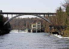
Deutsch: Die Traunfallbrücke. Eine Stahlbeton-Brücke, die 1925 nach einem Entwurf des Architekten Julius Schulte errichtet, im 2. Weltkrieg zerstört und 1948 in gleicher Form wieder aufgebaut wurde.
Media in category "Traunfallbrücke"
The following 3 files are in this category, out of 3 total.
-
Traunfall (2).JPG 1,253 × 1,772; 2.35 MB
-
Traunfall (4).JPG 1,772 × 1,253; 2.44 MB
-
Traunfallbrücke.JPG 1,772 × 1,253; 2.27 MB


