Category:Travel maps of Rochester, New York
Media in category "Travel maps of Rochester, New York"
The following 12 files are in this category, out of 12 total.
-
 Map - Rochester NY - Amtrak.png 565 × 432; 62 KB
-
 Map - Rochester NY - Amtrak.svg 744 × 1,052; 740 KB
-
 Map - Rochester NY - overview.png 3,008 × 3,418; 1.79 MB
-
 Map - Rochester NY - overview.svg 1,628 × 1,850; 1.47 MB
-
 Map - Rochester NY Airport.png 1,659 × 972; 503 KB
-
 Map - Rochester NY Airport.svg 1,659 × 972; 1.32 MB
-
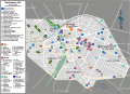
 Map - Rochester NY Downtown - big icons.png 1,840 × 1,331; 954 KB
-
 Map - Rochester NY Downtown - big icons.svg 1,658 × 1,201; 943 KB
-
 Map - Rochester NY Downtown 2.png 2,709 × 1,468; 849 KB
-
 Map - Rochester NY Downtown 2.svg 744 × 1,052; 972 KB
-
 Map - Rochester NY Downtown.png 3,578 × 2,666; 1.85 MB
-
 Map - Rochester NY Downtown.svg 744 × 1,052; 982 KB


