Category:Trinitarian Church (Bad Church), Eger
| Object location | | View all coordinates using: OpenStreetMap |
|---|
|
This is a category about a monument in Hungary. Identifier: 5602 |
unfinished monastery church in Eger  | |||||
| Upload media | |||||
| Instance of |
| ||||
|---|---|---|---|---|---|
| Location | Eger, Eger District, Heves County, Hungary | ||||
| Street address |
| ||||
| Has use | |||||
 | |||||
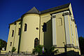
English: : The former Trinitarian temple, now Church Gallery. Built between 1725-1771 (architect: Kilian Ignaz Dientzenhofer.?). After dissolved the order in 1784, the church equipment is auctioned and used for storage. Now, partially restored, temporary exhibition space and part of the Eger Culture and Arts Center institution. - Bartók Sq., Eger, Heves County, Hungary.
Magyar: : Trinitárius templom avagy a Rossztemplom. A "Rossztemplom" névet azért kapta mert a mintegy kétszázötven éves történetében elhúzódó építkezések, sorsára hagyatottság, pusztulás majd kényszerhasználat, helyreállítások és hasznosítási próbálkozások követték egymást. Jelenleg Templom Galéria az egykori trinitárius rend templomában . Egri Kulturális és Művészeti Központ. Műemlék Azonosító: 5602 (törzsszám 1922) - Heves megye, Eger, Károlyváros, Bartók Béla tér, Trinitárius u. 5.
Media in category "Trinitarian Church (Bad Church), Eger"
The following 5 files are in this category, out of 5 total.
-
 Church Gallery in Trinitárius Street, Eger, 2016 Hungary.jpg 1,704 × 2,272; 1.02 MB
-
 Trinitárius templom (5602. számú műemlék) 2.jpg 1,063 × 1,600; 634 KB
-
 Trinitárius templom (5602. számú műemlék) 3.jpg 1,063 × 1,600; 592 KB
-
 Trinitárius templom (5602. számú műemlék).jpg 1,600 × 1,063; 705 KB
-
 Trinitárius templom, Eger, 2016 Hungary.jpg 2,272 × 1,704; 952 KB

_2.jpg)
_3.jpg)
.jpg)