Category:Tritle Peak
.jpg)
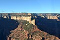
English: Tritle Peak, directly below Roosevelt Point, on the ridgeline.
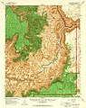
- Roosevelt Point is located directly southwest of Vista Encantada, on the East Face of the Walhalla Plateau. The ridgeline of Tritle Peak, separates the watersheds of Upper Nankoweap Canyon, north, and Upper Kwagunt Canyon, south.
- The ridgeline is composed of Supai Group - redbeds. Tritle Peak is the remainder of Coconino Sandstone cliffs, upon eroded slopes of Hermit Formation.
Landform in the Grand Canyon, Arizona | |||||
| Upload media | |||||
| Location | Arizona | ||||
|---|---|---|---|---|---|
 | |||||
Media in category "Tritle Peak"
The following 8 files are in this category, out of 8 total.
-
 Arizona. LOC 99446126-11.jpg 4,883 × 6,157; 6.27 MB
-
 Arizona. LOC 99446126-7.jpg 4,873 × 6,139; 4.85 MB
-
 Grand Canyon DEIS Aerial Tritle Peak & Roosevelt Point (5477293392).jpg 3,200 × 2,125; 1.59 MB
-
 Grand Canyon desde Roosevelt Point. 07.jpg 3,264 × 2,448; 9.16 MB
-
 Grand Canyon National Park (NR) Roosevelt Point 0239 (5898617529).jpg 10,000 × 4,138; 5.61 MB
-
 Grand Canyon panorama with rock formation 3.jpg 1,825 × 1,276; 449 KB
-
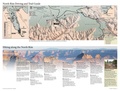 NPS grand-canyon-north-rim-trail-map.pdf 3,375 × 2,550; 660 KB
-
 Tritle Peak from Roosevelt Point.jpg 2,987 × 2,373; 2.51 MB


_Roosevelt_Point_0239_(5898617529).jpg)

