Category:Tur Langton
English: Tur Langton (derived from the Anglo-Saxon word for an enclosure, meaning "long town").
village in Leicestershire, England, UK  | |||||
| Upload media | |||||
| Instance of | |||||
|---|---|---|---|---|---|
| Location | Harborough, Leicestershire, East Midlands, England | ||||
| Population |
| ||||
| Area |
| ||||
 | |||||
Subcategories
This category has only the following subcategory.
A
Media in category "Tur Langton"
The following 131 files are in this category, out of 131 total.
-
 A tree lined Mere Road - geograph.org.uk - 3335628.jpg 2,974 × 2,342; 2.22 MB
-
 Across the fields to Shangton Church - geograph.org.uk - 4443821.jpg 480 × 640; 105 KB
-
 Along the road to Shangton - geograph.org.uk - 4443816.jpg 640 × 480; 91 KB
-

-
 B6047 Melton Road near Shangton - geograph.org.uk - 3335335.jpg 4,000 × 3,000; 3.27 MB
-
 B6047 through Tur Langton - geograph.org.uk - 962032.jpg 640 × 412; 69 KB
-
 Bridleway to Tur Langton - geograph.org.uk - 1008295.jpg 640 × 411; 87 KB
-
 By the side of St Andrew's Church - geograph.org.uk - 962031.jpg 640 × 585; 105 KB
-
 Chapel wall - geograph.org.uk - 4443135.jpg 480 × 640; 128 KB
-
 Church view - geograph.org.uk - 4434917.jpg 480 × 640; 62 KB
-
 Cranoe Road near Stonton Wyville - geograph.org.uk - 3348267.jpg 4,000 × 3,000; 4.69 MB
-
 Cranoe Road towards Tur Langton - geograph.org.uk - 3348262.jpg 1,582 × 1,367; 593 KB
-
 Crown Inn (geograph 3554063).jpg 1,600 × 1,200; 439 KB
-
 Derelict pub in Tur Langton - geograph.org.uk - 3335183.jpg 3,572 × 2,171; 2.32 MB
-
 Farm buildings along Shangton Road - geograph.org.uk - 3335259.jpg 3,991 × 2,757; 3.42 MB
-

-
 Farm buildings at Tur Langton - geograph.org.uk - 1008296.jpg 640 × 426; 56 KB
-

-
 Farmland along Kibworth Road - geograph.org.uk - 3335051.jpg 3,838 × 2,861; 3.06 MB
-
 Farmland near Kibworth Hall - geograph.org.uk - 3334871.jpg 3,178 × 2,197; 2 MB
-
 Farmland north of Kibworth Road - geograph.org.uk - 3334831.jpg 3,199 × 2,196; 1.97 MB
-
 Field Path towards Shangton - geograph.org.uk - 4443813.jpg 640 × 480; 74 KB
-
 Field Road - geograph.org.uk - 4434923.jpg 480 × 640; 79 KB
-
 Fields near to Tur Langton - geograph.org.uk - 1008293.jpg 640 × 480; 122 KB
-
 Fields north of Kibworth Road - geograph.org.uk - 3334879.jpg 3,510 × 2,247; 2.79 MB
-
 Footpath along Cranoe Road - geograph.org.uk - 3348265.jpg 3,999 × 2,769; 3.61 MB
-

-
 Footpath junction - geograph.org.uk - 1008292.jpg 640 × 480; 141 KB
-
 Footpath near Tur Langton - geograph.org.uk - 4443127.jpg 480 × 640; 79 KB
-
 Footpath near Tur Langton - geograph.org.uk - 4443129.jpg 480 × 640; 138 KB
-
 Gate and stile - geograph.org.uk - 1008297.jpg 640 × 443; 85 KB
-
 Gates along Kibworth Road - geograph.org.uk - 3334860.jpg 3,507 × 2,865; 3.01 MB
-
 Grassland heading south - geograph.org.uk - 4434914.jpg 480 × 640; 78 KB
-
 Heading east along Mere Road - geograph.org.uk - 3335622.jpg 2,843 × 2,220; 2.08 MB
-
 Heading north along Shangton Road - geograph.org.uk - 3335295.jpg 3,757 × 2,766; 3.52 MB
-

-
 Heading towards Tur Langton - geograph.org.uk - 4443823.jpg 640 × 480; 78 KB
-
 Heading west along Kibworth Road - geograph.org.uk - 3335099.jpg 3,945 × 2,840; 3.46 MB
-
 Hedge and fingerpost along Cranoe Road - geograph.org.uk - 3348516.jpg 2,007 × 1,921; 1.25 MB
-
 Kibworth Road heading towards Tur Langton - geograph.org.uk - 3334847.jpg 4,000 × 3,000; 3.41 MB
-
 Kibworth Road heading towards Tur Langton - geograph.org.uk - 3334978.jpg 3,974 × 2,677; 3.17 MB
-
 Kibworth Road near Tur Langton - geograph.org.uk - 3334962.jpg 3,592 × 2,817; 3.1 MB
-
 Kibworth Road towards Tur Langton - geograph.org.uk - 3335074.jpg 3,203 × 2,566; 2.4 MB
-
 Looking east along the Main Street of Tur Langton (geograph 3335142).jpg 4,000 × 3,000; 4.96 MB
-
 Muddy stile - geograph.org.uk - 1008298.jpg 640 × 487; 110 KB
-
 New build - geograph.org.uk - 4434903.jpg 640 × 480; 57 KB
-

-
 Occupational History of Tur Langton - 1881.jpg 481 × 537; 53 KB
-
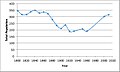 Population Graph of Tur Langton, 1801-2011.jpg 481 × 289; 27 KB
-
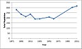 Population time series of Tur Langton.jpg 481 × 289; 25 KB
-
 Public bridleway to Mere Road - geograph.org.uk - 3335087.jpg 3,300 × 2,463; 2.8 MB
-
 Shangton Road approaching Tur Langton - geograph.org.uk - 505964.jpg 571 × 640; 119 KB
-
 Shangton Road in Tur Langton - geograph.org.uk - 6118609.jpg 800 × 476; 110 KB
-
 Sheep south of Shangton - geograph.org.uk - 505962.jpg 640 × 460; 91 KB
-
 The Main Street of Tur Langton (geograph 7285647).jpg 1,024 × 744; 212 KB
-
 The Main Street of Tur Langton - geograph.org.uk - 3335124.jpg 3,386 × 2,507; 2.67 MB
-
 Tur Langton -Main Street - geograph.org.uk - 6298949.jpg 1,600 × 1,200; 388 KB
-
 Tur Langton Bulls Head - geograph.org.uk - 2872906.jpg 640 × 480; 170 KB
-
 Tur Langton Church - geograph.org.uk - 4434910.jpg 480 × 640; 77 KB
-
 Tur Langton Church in the distance - geograph.org.uk - 4443827.jpg 480 × 640; 79 KB
-
 Tur Langton Crown - geograph.org.uk - 2872920.jpg 640 × 480; 174 KB
-
 Tur Langton houses - geograph.org.uk - 4434913.jpg 640 × 480; 71 KB
-
 Tur Langton, Shangton Road - geograph.org.uk - 3335220.jpg 3,311 × 2,068; 1.91 MB
-
 Tur Langton, the telephone box - geograph.org.uk - 5271379.jpg 640 × 480; 59 KB
-
 View towards Tur Langton - geograph.org.uk - 3334923.jpg 3,157 × 2,451; 2.34 MB
-
 Village street, Tur Langton - geograph.org.uk - 962025.jpg 640 × 398; 57 KB
-
 Village street, Tur Langton - geograph.org.uk - 962027.jpg 640 × 468; 81 KB
-
 Village street, Tur Langton - geograph.org.uk - 962034.jpg 640 × 458; 80 KB
-
 Welcome to Tur Langton - geograph.org.uk - 587032.jpg 640 × 387; 94 KB
-

-
 A meeting of pipes - geograph.org.uk - 181099.jpg 640 × 520; 140 KB
-
 A6 Harborough Road - geograph.org.uk - 587865.jpg 640 × 401; 83 KB
-
 Along the edge of the square to the west - geograph.org.uk - 404679.jpg 640 × 480; 128 KB
-
 Ancient Fish Ponds at Stonton Wyville - geograph.org.uk - 232765.jpg 640 × 480; 79 KB
-
 Approaching West Langton - geograph.org.uk - 204761.jpg 640 × 480; 105 KB
-
 B6047 Melton Road - geograph.org.uk - 505920.jpg 640 × 497; 110 KB
-
 B6047 towards Melton Mowbray - geograph.org.uk - 404683.jpg 640 × 480; 85 KB
-
 Barn - geograph.org.uk - 505589.jpg 619 × 640; 96 KB
-
 Barns alongside a Roman Road - geograph.org.uk - 417212.jpg 640 × 447; 71 KB
-
 Big Shed - geograph.org.uk - 279953.jpg 640 × 480; 56 KB
-
 Brick barn - geograph.org.uk - 587860.jpg 640 × 423; 104 KB
-
 Bridge south of Shangton Village - geograph.org.uk - 505959.jpg 640 × 515; 126 KB
-
 Bridleway from Noseley - geograph.org.uk - 505574.jpg 579 × 640; 117 KB
-
 Bridleway to Noseley - geograph.org.uk - 505577.jpg 640 × 477; 103 KB
-
 CARE - geograph.org.uk - 505928.jpg 640 × 459; 104 KB
-
 Cattle next to Roman Road - geograph.org.uk - 505599.jpg 640 × 450; 116 KB
-
 Church Causeway - geograph.org.uk - 279960.jpg 640 × 480; 127 KB
-
 Conversion plans - geograph.org.uk - 279957.jpg 326 × 640; 60 KB
-
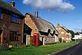
 Cottages on Church Lane - geograph.org.uk - 279959.jpg 640 × 540; 114 KB
-
 Cows near Melton Road - geograph.org.uk - 589829.jpg 640 × 412; 91 KB
-
 Cranoe Road in Leicestershire - geograph.org.uk - 587037.jpg 640 × 484; 125 KB
-
 Cranoe Road near Tur Langton - geograph.org.uk - 587033.jpg 640 × 415; 100 KB
-
 Cranoe Road towards Tur Langton - geograph.org.uk - 587039.jpg 640 × 453; 142 KB
-
 Croxfield Spinney, Leicestershire - geograph.org.uk - 587043.jpg 640 × 488; 152 KB
-
 Edge of oil seed rape field - geograph.org.uk - 404686.jpg 640 × 480; 104 KB
-
 Farm buildings - geograph.org.uk - 505571.jpg 640 × 475; 91 KB
-
 Farmland near Shangton - geograph.org.uk - 505946.jpg 640 × 447; 98 KB
-
 Farmland north of Kibworth Road - geograph.org.uk - 589810.jpg 640 × 424; 132 KB
-
 Farmland off Mere Road - geograph.org.uk - 505976.jpg 516 × 640; 115 KB
-
 Ford next to Hardwick Bridge - geograph.org.uk - 505594.jpg 561 × 640; 163 KB
-
 Gateway - geograph.org.uk - 279594.jpg 480 × 640; 156 KB
-
 Grange Farm, Leicestershire - geograph.org.uk - 587866.jpg 640 × 433; 96 KB
-
 Kibworth Road - geograph.org.uk - 332842.jpg 640 × 480; 73 KB
-
 Kibworth Road, Tur Langton - geograph.org.uk - 589815.jpg 640 × 442; 117 KB
-
 Kibworth Shooting Ground - geograph.org.uk - 587863.jpg 640 × 410; 105 KB
-
 Leicestershire countryside - geograph.org.uk - 589833.jpg 551 × 640; 106 KB
-

-
 Main Street, looking towards Shangton - geograph.org.uk - 505950.jpg 640 × 482; 112 KB
-
 Main Street, Tur Langton - geograph.org.uk - 589818.jpg 640 × 390; 81 KB
-
 Main Street, Tur Langton - geograph.org.uk - 589827.jpg 640 × 561; 165 KB
-
 Melton Road near Shangton - geograph.org.uk - 505940.jpg 640 × 419; 97 KB
-
 Mere Road - geograph.org.uk - 181097.jpg 640 × 480; 95 KB
-
 Mere Road, Leicestershire - geograph.org.uk - 505967.jpg 640 × 455; 124 KB
-
 Mere Road, Leicestershire - geograph.org.uk - 505979.jpg 640 × 514; 145 KB
-
 Mill Farm, Stonton Wyville - geograph.org.uk - 232774.jpg 640 × 480; 125 KB
-
 North east across the square - geograph.org.uk - 404688.jpg 640 × 480; 76 KB
-
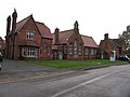 Old School at Church Langton - geograph.org.uk - 279955.jpg 640 × 480; 63 KB
-
 Opened 1875 - geograph.org.uk - 279956.jpg 356 × 640; 55 KB
-
 Pasture - geograph.org.uk - 204762.jpg 640 × 520; 89 KB
-
 Pond - geograph.org.uk - 404680.jpg 640 × 480; 140 KB
-
 Public Bridleway to Tur Langton - geograph.org.uk - 505972.jpg 640 × 511; 130 KB
-
 Roman Road Rocks - geograph.org.uk - 505584.jpg 640 × 523; 122 KB
-
 Rutted farm track - geograph.org.uk - 505947.jpg 530 × 640; 105 KB
-
 Shangton Road towards Tur Langton - geograph.org.uk - 587027.jpg 640 × 424; 99 KB
-
 South from Shangton - geograph.org.uk - 181098.jpg 640 × 480; 91 KB
-

-

-
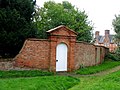 To the rectory - geograph.org.uk - 279958.jpg 640 × 480; 106 KB
-
 Track goes round the bend - geograph.org.uk - 404687.jpg 640 × 480; 89 KB
-
 Tur Langton - geograph.org.uk - 150667.jpg 640 × 427; 116 KB
-


.jpg)


.jpg)


.jpg)


