Category:Turfmarkt 29, Makkum
| Object location | | View all coordinates using: OpenStreetMap |
|---|
 | |||||
| Upload media | |||||
| Instance of |
| ||||
|---|---|---|---|---|---|
| Location | Makkum, Friesland, Netherlands | ||||
| Street address |
| ||||
| Located on street | |||||
| Heritage designation |
| ||||
 | |||||
|
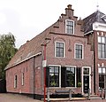
This is a category about rijksmonument number 39397
|
| Address |
|
Media in category "Turfmarkt 29, Makkum"
The following 6 files are in this category, out of 6 total.
-
 Burgerwoningen - Makkum - 20525249 - RCE.jpg 1,200 × 900; 141 KB
-
 Gevels - Makkum - 20150393 - RCE.jpg 1,200 × 806; 210 KB
-
 Naar het westen - Makkum - 20150384 - RCE.jpg 1,200 × 806; 177 KB
-
 Pruikmakershoek - Makkum - 20150306 - RCE.jpg 1,200 × 1,199; 240 KB
-
 Turfmarkt29 Makkum.jpg 2,628 × 2,526; 848 KB
-
 Voorgevel, linker zijgevel - Makkum - 20334160 - RCE.jpg 1,197 × 1,200; 369 KB


