Category:Tydje kapell
| Object location | | View all coordinates using: OpenStreetMap |
|---|
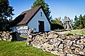
church building in Åmål Municipality, Älvsborg County, Sweden  | |||||
| Upload media | |||||
| Instance of | |||||
|---|---|---|---|---|---|
| Location | Åmål Municipality, Västra Götaland County, Sweden | ||||
| Diocese | |||||
| Has use | |||||
| Occupant |
| ||||
| Heritage designation |
| ||||
| Date of official opening |
| ||||
 | |||||
|
This is a category about an ecclesiastical monument in Sweden, number 21300000021340 in the RAÄ buildings database.
|
|
This is a category about a protected building in Sweden, number 21400000676045 in the RAÄ buildings database.
|
Media in category "Tydje kapell"
The following 5 files are in this category, out of 5 total.
-
 Tydje kapell - KMB - 16000200012294.jpg 800 × 589; 116 KB
-
 Tydje kapell wrought iron gate 2017.jpg 3,057 × 2,293; 1.45 MB
-
 TydjekapellAmal.jpg 2,561 × 3,456; 11.26 MB
-
 TydjekapellAmal1-8451.jpg 5,184 × 3,456; 20.34 MB
-
 TydjekapellAmal3.jpg 3,456 × 5,184; 13.83 MB


