Category:U.S. Route 101 in Oregon
section of U.S. Numbered Highway in Oregon, United States   | |||||
| Upload media | |||||
| Instance of | |||||
|---|---|---|---|---|---|
| Part of | |||||
| Location |
| ||||
| Transport network | |||||
| Owned by | |||||
| Maintained by | |||||
| Length |
| ||||
| Terminus | |||||
| |||||
| 86 · 99 · 101 · 103 · 104 · 120 |
| I-5 · I-82 · I-84 · I-105 · I-205 · I-305 · I-405 · I-505 |
| US-20 · US-26 · US-30 · US-95 · US-97 · US-101 · US-197 · US-199 · US-395 · US-730 |
English: This category should contain files related to U.S. Route 101 in Oregon.
English: Media related to U.S. Route 101 in Oregon (Oregon Coast Highway), a 363.11-mile (584.37 km) section of Numbered Highway in Oregon, United States, that connects U.S. Route 101 in California with U.S. Route 101 in Washington.
Subcategories
This category has the following 6 subcategories, out of 6 total.
J
V
Media in category "U.S. Route 101 in Oregon"
The following 200 files are in this category, out of 210 total.
(previous page) (next page)-
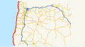 Oregon U.S. Route 101.svg 1,152 × 640; 1.04 MB
-
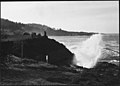 "SPOUTING HORN" AT DEPOE BAY - NARA - 520105.jpg 3,000 × 2,139; 1.36 MB
-
 14-978 Cape Creek Bridge & Heceta LH Keepers House, OR (22714556912).jpg 3,046 × 1,847; 2.3 MB
-
 2018-03-10 Garibaldi 01.jpg 2,448 × 1,103; 813 KB
-
 2018-03-10 Garibaldi 02.jpg 3,648 × 2,736; 2.2 MB
-
 2018-03-10 Garibaldi 03.jpg 3,648 × 2,736; 2.4 MB
-
 2018-03-10 Garibaldi 05.jpg 3,648 × 2,736; 2.25 MB
-
 2018-03-10 Garibaldi 06.jpg 3,648 × 2,736; 2.34 MB
-
 2018-03-10 Garibaldi 07.jpg 3,648 × 2,736; 2.31 MB
-
 2018-03-10 Garibaldi 08.jpg 3,648 × 2,736; 2.13 MB
-
 2018-03-10 Nehalem 01.jpg 3,648 × 2,736; 2.33 MB
-
 2018-03-10 Nehalem 02.jpg 3,648 × 2,736; 2.19 MB
-
 2018-03-10 Nehalem 04.jpg 3,648 × 2,736; 2.32 MB
-
 2018-03-10 Wheeler 02.jpg 3,648 × 2,736; 1.74 MB
-
 2018-03-10 Wheeler 04.jpg 3,648 × 2,736; 2.22 MB
-
 Aerial view of the repairs (50838850942).jpg 5,472 × 3,648; 12.21 MB
-
 Approaching the work zone (50838850742).jpg 6,000 × 4,000; 7.66 MB
-
 Astoria-Megler Bridge heading north 02.JPG 3,804 × 2,370; 4.47 MB
-
 Bandon, Oregon - Sea Star Bistro 01.jpg 4,288 × 2,848; 6.81 MB
-
 Bandon, Oregon - Sea Star Bistro 02.jpg 4,288 × 2,848; 4.8 MB
-
 Beach north of Cape Sebastian.jpg 1,000 × 545; 99 KB
-
 Beach shots along Hwy 101…near Hunter's cove (7975462358).jpg 2,121 × 1,414; 2.7 MB
-
 Beach Trip 06 018.jpg 1,470 × 736; 168 KB
-
 Bicycle the OR Coastline (50673625876).jpg 3,712 × 5,568; 20.4 MB
-
 BikeGoldBeachUS101Fall2020resize (50673661152).jpg 2,458 × 1,626; 1.09 MB
-
 Bikes with RVs US101HumbugMtnArea Fall2020 (50672832743).jpg 4,521 × 3,324; 15.09 MB
-
 BikeUS101nearPortOrfordFall2020resize (50673577821).jpg 2,498 × 1,601; 641 KB
-
 BikeUS101SunSetFall2020 (50673720492).jpg 5,568 × 3,622; 15.78 MB
-
 Biking101nearHumbugMtnFall2020resize (50672830263).jpg 2,341 × 1,708; 784 KB
-
 BikingORCoast US101 Fall2020 (50673718402).jpg 3,468 × 5,201; 19.01 MB
-
 BikingPortOrford Boat (50672881953).jpg 5,124 × 3,400; 19.07 MB
-
 Border between Chetco, Oregon and Smith River, California.jpg 800 × 600; 206 KB
-
 Broken mesh.jpg 3,024 × 4,032; 5.06 MB
-
 Cape Creek Tunnel-1.jpg 5,335 × 3,557; 2.07 MB
-
 Cape Perpetua Whispering Spruce View 4.jpg 500 × 333; 59 KB
-
 Choppers on Hwy 101.jpg 4,145 × 3,316; 844 KB
-
 Cleanup efforts underway on U.S. 101.jpg 2,304 × 1,536; 1.62 MB
-
 Collapse on U.S. 101 north of Gold Beach (16081167802).jpg 480 × 640; 172 KB
-
 Coos Bay OR - street scenery.jpg 2,592 × 1,944; 634 KB
-
 Crews work to clear the highway.jpg 3,024 × 4,032; 3.07 MB
-
 Dim out zone (32045053014).jpg 2,909 × 2,368; 3.6 MB
-
 Dim out zone (32734300462).jpg 1,469 × 1,148; 800 KB
-
 Dorchester House - Lincoln City Oregon.jpg 1,600 × 745; 263 KB
-
-
 Driftwood Beach-1.jpg 5,472 × 3,648; 2.13 MB
-
 End US 30 Marker, Astoria, Oregon.jpg 2,448 × 3,264; 2.09 MB
-
 Gearhart Builders Supply bus stop - NorthWest POINT (5937374608).jpg 3,648 × 2,736; 4.33 MB
-
 Goodwin-Wilkinson Farmhouse - Warrenton Oregon.jpg 3,782 × 2,684; 3.31 MB
-
 Harbor sinkhole (24691134235).jpg 960 × 960; 174 KB
-
 Heceta Head and House.jpg 3,035 × 1,240; 2.21 MB
-
 Heceta Head angled.jpg 2,137 × 1,240; 1.73 MB
-
 Heceta Head Lighthouse under renovation, seen from U.S. Route 101.jpg 4,477 × 2,985; 3.32 MB
-
 HUMBUG MOUNTAIN - NARA - 520143.jpg 3,000 × 1,987; 1.38 MB
-
 IN NORTHERN CURRY COUNTY - NARA - 520142.jpg 3,000 × 2,129; 1.73 MB
-
 Landslide on U.S. 101 near Cannon Beach (33017454576).png 480 × 640; 729 KB
-
 Laying asphalt (50838038953).jpg 6,000 × 4,000; 7.88 MB
-
 Lots of mud and rocks (7030409383).jpg 640 × 480; 59 KB
-
 March 30 slide on U.S. 101 (6884308842).jpg 640 × 480; 51 KB
-
 Metal netting prevents materials from falling on the highway.jpg 2,304 × 1,536; 1.61 MB
-
 Milepost 316 on U.S. 101 (6899297818).jpg 640 × 480; 65 KB
-
 Nehalem Oregon - Highway 101.jpg 1,597 × 800; 359 KB
-
 Nehalem, Oregon.jpg 4,135 × 2,757; 1.53 MB
-
 Neotsu.jpg 1,280 × 960; 323 KB
-
 Newport, Oregon.jpg 3,657 × 2,717; 4.98 MB
-
 Observing from a safe distance.jpg 1,536 × 2,304; 690 KB
-
 Ocean Cove Inn (Yachats, Oregon).jpg 5,472 × 3,648; 2.92 MB
-
 Ocean Lake on Hwy 101.jpg 4,871 × 3,247; 1.71 MB
-
 On Hwy 101 near Otter Rck Oregon (7975457967).jpg 2,121 × 1,414; 2.79 MB
-
 Oregon 101 Collapse CalTrans 022619.jpeg 1,220 × 1,436; 367 KB
-
 Oregon 18 interchange near Lincoln City..jpeg 2,448 × 3,264; 2.95 MB
-
 Oregon 18 interchange near Lincoln City.jpeg 2,448 × 3,264; 1.71 MB
-
 Oregon Coast Highway Washout.jpg 4,304 × 2,869; 1.57 MB
-
 Oregon Coast.JPG 1,600 × 1,200; 266 KB
-
 OREGON MYRTLE TREES - NARA - 520155.jpg 3,000 × 1,897; 1.24 MB
-
 Overhead view of the slide area near Wheeler.jpg 2,304 × 1,536; 1.14 MB
-
 Overlooking the slide on U.S. 101.jpg 2,304 × 1,536; 1.4 MB
-
 Pacific Coast Scenic Byway - Oregon - A Contrast of Elements - NARA - 7720925.jpg 3,072 × 2,048; 4.21 MB
-
 Pacific Coast Scenic Byway - Oregon - A Peek at the Pacific Shoreline - NARA - 7720913.jpg 3,060 × 2,048; 4.14 MB
-
 Pacific Coast Scenic Byway - Oregon - A Peek at the Pacific Shoreline - NARA - 7720915.jpg 3,042 × 2,048; 3.93 MB
-

-
 Pacific Coast Scenic Byway - Oregon - Aerial View of Bandon Marsh - NARA - 7720889.jpg 1,531 × 1,015; 100 KB
-
-
 Pacific Coast Scenic Byway - Oregon - Aerial View of Cape Meares - NARA - 7720890.jpg 1,793 × 1,207; 616 KB
-

-

-
-
 Pacific Coast Scenic Byway - Oregon - Alsea Bay Interpretive Center - NARA - 7720901.jpg 3,072 × 2,048; 3.83 MB
-

-
 Pacific Coast Scenic Byway - Oregon - Bridge on Oregon's Pacific Coast - NARA - 7720929.jpg 2,048 × 3,072; 4.12 MB
-

-
 Pacific Coast Scenic Byway - Oregon - Cape Meares Octopus Tree - NARA - 7720893.jpg 1,532 × 2,049; 1.95 MB
-
 Pacific Coast Scenic Byway - Oregon - Cape Perpetua Visitor Center - NARA - 7720947.jpg 3,552 × 2,402; 8.89 MB
-
 Pacific Coast Scenic Byway - Oregon - Captain Cook Point - NARA - 7720895.jpg 1,536 × 2,048; 1.72 MB
-
 Pacific Coast Scenic Byway - Oregon - Cars at a Pacific Ocean Overlook - NARA - 7720921.jpg 3,054 × 2,048; 4.49 MB
-
 Pacific Coast Scenic Byway - Oregon - Coastal Shores of the Pacific - NARA - 7720907.jpg 2,048 × 3,042; 4.37 MB
-
 Pacific Coast Scenic Byway - Oregon - Coastal Shores of the Pacific - NARA - 7720908.jpg 3,054 × 2,048; 4.12 MB
-
 Pacific Coast Scenic Byway - Oregon - Coastal Shores of the Pacific - NARA - 7720909.jpg 3,060 × 2,048; 4.17 MB
-
 Pacific Coast Scenic Byway - Oregon - Coastal Shores of the Pacific - NARA - 7720910.jpg 2,048 × 3,072; 4.77 MB
-
 Pacific Coast Scenic Byway - Oregon - Conde B. McCullough - NARA - 7720900.jpg 3,072 × 2,048; 3.75 MB
-
-
 Pacific Coast Scenic Byway - Oregon - Harbor on Oregon's Pacific Coast - NARA - 7720918.jpg 3,060 × 2,048; 4.19 MB
-
 Pacific Coast Scenic Byway - Oregon - Heceta Head Lighthouse - NARA - 7720949.jpg 3,584 × 2,410; 9.02 MB
-
 Pacific Coast Scenic Byway - Oregon - Neahkahnie Mountain - NARA - 7720944.jpg 3,464 × 2,393; 8.14 MB
-
 Pacific Coast Scenic Byway - Oregon - Ocean and Forested Hills - NARA - 7720916.jpg 2,048 × 3,072; 1.36 MB
-

-

-
-

-

-
-

-
 Pacific Coast Scenic Byway - Oregon - Three Arch Rocks - NARA - 7720954.jpg 1,748 × 1,182; 120 KB
-
 Pacific Coast Scenic Byway - Oregon - Tillamook County Pastures - NARA - 7720945.jpg 3,544 × 2,185; 7.47 MB
-

-

-

-

-

-
 Pacific Coast Scenic Byway - Oregon - Yaquina Head, Oregon Islands - NARA - 7720941.jpg 1,778 × 1,207; 181 KB
-
 PASTORAL SCENE - NARA - 520167.jpg 3,000 × 2,149; 1.35 MB
-
 Repairs to 101 (6899297926).jpg 640 × 480; 43 KB
-
 Roadhouse on Hwy 101.jpg 4,275 × 2,850; 1.89 MB
-
 Sculpture (Gardiner, Oregon).jpg 4,608 × 3,072; 5.08 MB
-
 Seven Gables on Hwy 101.jpg 4,888 × 3,259; 1.7 MB
-
 Sinkhole in Harbor, Oregon 2.jpg 960 × 960; 202 KB
-
 Sinkhole in Harbor, Oregon 3.jpg 960 × 720; 172 KB
-
 Sinkhole in Harbor, Oregon.jpg 960 × 960; 196 KB
-
 Sinkhole on U.S. 101 near Harbor (24064307443).jpg 960 × 960; 173 KB
-
 Slide on U.S. 101.jpg 2,000 × 1,192; 851 KB
-
 Slide starts here (7030409427).jpg 640 × 480; 41 KB
-
 Sliding down the hill.jpg 2,304 × 1,536; 1.83 MB
-
 Slumping highway (6771794469).jpg 640 × 480; 46 KB
-
 Some debris cleared (7030409293).jpg 640 × 480; 56 KB
-
 Start of US 26 in Oregon.jpg 2,448 × 3,264; 1.97 MB
-
 Sunset near Taft from U.S. 101 ny Michael Keyes (8272125815).jpg 13,599 × 7,667; 31.98 MB
-
 Taft on Hwy 101.jpg 4,045 × 3,236; 1.53 MB
-
 The Tunnel at Heceta Head (35340519162).jpg 1,278 × 1,310; 231 KB
-
 Truck equipped with plow blade to clear the road.jpg 2,304 × 1,536; 1.04 MB
-
 U.S. 101 (6839456600).jpg 640 × 480; 74 KB
-
 U.S. 101 aerial view (50987269471).jpg 5,472 × 3,648; 6.24 MB
-
 U.S. 101 Arizona Paving Thursday March 16 (52760441908).jpg 2,000 × 1,500; 932 KB
-
 U.S. 101 Arizona Slide paving, March 16 (52759954481).jpg 2,000 × 1,500; 990 KB
-
 U.S. 101 Arizona Slide paving, March 16 (52759954501).jpg 2,000 × 1,500; 911 KB
-
 U.S. 101 Arizona Slide paving, March 16 (52760203594).jpg 2,000 × 1,500; 885 KB
-
 U.S. 101 at 10th Street in Port Orford (50666935617).jpg 2,400 × 1,500; 611 KB
-
 U.S. 101 at 15th Street in Port Orford (50666862886).jpg 2,400 × 1,500; 717 KB
-
 U.S. 101 at 20th Street (Reedsport) (33139171842).jpg 1,600 × 900; 655 KB
-
 U.S. 101 at Jackson Street in Port Orford (50666872561).jpg 2,400 × 1,500; 814 KB
-
 U.S. 101 at Jefferson Street in Port Orford (50666959652).jpg 2,400 × 1,500; 767 KB
-
 U.S. 101 at Madrona Avenue in Port Orford (50666882131).jpg 2,400 × 1,500; 544 KB
-
 U.S. 101 at milepost 316 (6899298108).jpg 640 × 480; 53 KB
-
 U.S. 101 at milepost 333 near Gold Beach (6771794541).jpg 640 × 480; 62 KB
-
 U.S. 101 at milpost 316 before repairs (6899297844).jpg 640 × 480; 65 KB
-
 U.S. 101 at the Harbor Drive parking lot in Port Orford (50666122203).jpg 2,400 × 1,500; 667 KB
-
 U.S. 101 at the intersection of 8th and Oregon Streets (Port Orford) (50666101083).jpg 2,400 × 1,500; 679 KB
-
 U.S. 101 Bunker Hill sidewalk replacement (Coos Bay) (51553790582).jpg 2,000 × 1,500; 705 KB
-
 U.S. 101 Coos Bay high water.jpg 2,093 × 2,953; 1.37 MB
-
 U.S. 101 crosswalk at 12th Street in Port Orford (50666938937).jpg 2,400 × 1,500; 810 KB
-
 U.S. 101 flooding at Tillamook (32782398336).jpg 458 × 640; 158 KB
-
 U.S. 101 Hooskanaden realignment project (50123424707).jpg 4,000 × 3,000; 4.75 MB
-
 U.S. 101 in Barview.jpg 3,648 × 2,736; 2.15 MB
-
 U.S. 101 in Lincoln County (6839456644).jpg 640 × 480; 77 KB
-
 U.S. 101 mp 170.5 new retaining wall (51026782531).jpg 480 × 360; 82 KB
-
 U.S. 101 mp 170.5 retaining wall repair (51026054088).jpg 480 × 360; 66 KB
-
 U.S. 101 Neahkahnie Mountain Rock Wall (3266956755).jpg 2,049 × 1,464; 1.41 MB
-
 U.S. 101 Neahkahnie Mountain Rock Wall (3266957251).jpg 1,488 × 2,073; 1.31 MB
-
 U.S. 101 Neahkahnie Mountain Rock Wall (3266958157).jpg 2,192 × 2,188; 2.2 MB
-
 U.S. 101 Neahkahnie Mountain Rock Wall (3267791428).jpg 2,700 × 1,961; 2.06 MB
-
 U.S. 101 near milepost 335 (7045393913).jpg 640 × 480; 62 KB
-
 U.S. 101 near Neskowin (6985577449).jpg 640 × 480; 83 KB
-
 U.S. 101 recovering drill rig (50986558028).jpg 5,472 × 3,648; 7.59 MB
-
 U.S. 101 repairs (50951082946).jpg 1,600 × 1,200; 279 KB
-
U.S. 101 Seaside high water Dec 2023 h.webm 48 s, 1,920 × 1,080; 31.46 MB
-
U.S. 101 Seaside high water Dec. 2023.webm 48 s, 608 × 1,080; 7.17 MB
-
 U.S. 101 Seaside high water.jpg 6,000 × 4,000; 12.34 MB
-
 U.S. 101 sidewalks in Bunker Hill (Coos Bay) (51553727762).jpg 2,000 × 1,500; 976 KB
-
 U.S. 101 slide (46307215235).jpg 480 × 360; 175 KB
-
 U.S. 101 slide damage (40256577743).jpg 480 × 360; 207 KB
-
 U.S. 101 slide detail (16080602795).png 1,148 × 2,040; 2.71 MB
-
 U.S. 101 slide perspective (33405130388).jpg 960 × 720; 701 KB
-
 U.S. 101 south of Newport Jan. 18 morning (6757225473).jpg 640 × 480; 59 KB
-
 U.S. 101 south of Newport Jan. 23 afternoon (6757225727).jpg 640 × 424; 57 KB
-
 U.S. 101 south of Newport Jan. 23 morning (6757225641).jpg 640 × 424; 27 KB
-
 U.S. 101 south of Newport on Jan. 19 afternoon (6757225571).jpg 640 × 480; 58 KB
-
 U.S. 101 traffic congestion in Bunker Hill (Coos Bay) (51553779297).jpg 2,000 × 1,500; 883 KB
-
 U.S. 101 work site (50951082916).jpg 1,200 × 1,600; 284 KB
-
 U.S. 101 work site (50952768783).jpg 960 × 640; 960 KB
-
 U.S. 101, high water near Fourmile.jpg 1,042 × 651; 235 KB
-
 U.S. 101-Flanagan traffic signal in south Coos Bay (51555259709).jpg 2,000 × 1,500; 823 KB
-
 U.S. Highway 101 gutter in Bunker Hill (Coos Bay) (51555250114).jpg 3,400 × 2,600; 4.27 MB
-
 U.S. Route 101 in Oregon-1.jpg 5,472 × 3,648; 2.08 MB
-
 U.S. Route 101 in Oregon-2.jpg 5,472 × 3,648; 1.86 MB
-
 U.S. Route 101 in Oregon-3.jpg 5,025 × 3,350; 2.67 MB
-
 US 101 & Business 101 Sign.JPG 4,320 × 3,240; 5.42 MB
-
 US 101 is closed due to an active landlside - March 2022.jpg 2,304 × 1,536; 1.79 MB
-
 US 101 Oregon 1926.svg 1,485 × 1,440; 30 KB
-
 US 101 Seaside flooding (32008925363).jpg 640 × 480; 303 KB
-
 US101 Bus MP 4.78, Lewis & Clark River Bridge, Astoria (7651563060).png 527 × 479; 269 KB
-
 US101 south of Gold Beach (6728247513).jpg 640 × 480; 29 KB
-
 US101OR.JPG 2,816 × 2,120; 1.43 MB

.jpg)


.jpg)
.jpg)


.jpg)

.jpg)
.jpg)
.jpg)
.jpg)
.jpg)
.jpg)
.jpg)
.jpg)


.jpg)

.jpg)
.jpg)

.jpg)


.jpg)

.jpg)


.png)
.jpg)
.jpg)
.jpg)

.jpg)


.jpg)

.jpg)


.jpg)

.jpg)


.jpg)

.jpg)

.jpg)

.jpg)

.jpg)
.jpg)
.jpg)
.jpg)
.jpg)
.jpg)
.jpg)
.jpg)
.jpg)
_(33139171842).jpg)
.jpg)
.jpg)
.jpg)
.jpg)
.jpg)
.jpg)
.jpg)
_(50666101083).jpg)
_(51553790582).jpg)

.jpg)
.jpg)
.jpg)

.jpg)
.jpg)
.jpg)
.jpg)
.jpg)
.jpg)
.jpg)
.jpg)
.jpg)
.jpg)
.jpg)

_(51553727762).jpg)
.jpg)
.jpg)
.png)
.jpg)
.jpg)
.jpg)
.jpg)
.jpg)
_(51553779297).jpg)
.jpg)
.jpg)

.jpg)
_(51555250114).jpg)


.jpg)
.png)
.jpg)

.jpg)