Category:Udimore
village in United Kingdom  | |||||
| Upload media | |||||
| Instance of | |||||
|---|---|---|---|---|---|
| Location | Rother, East Sussex, South East England, England | ||||
| Area |
| ||||
 | |||||
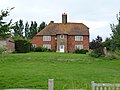
English: Udimore (pronounced you-d-more) is a village and civil parish in the Rother District of East Sussex, England. It is located five miles (8 km) west of Rye on the B2089 road to Brede.
Subcategories
This category has the following 4 subcategories, out of 4 total.
D
- Dumb Woman's Lane (11 F)
O
- Oasts in Udimore (24 F)
U
- St Mary's Church, Udimore (43 F)
- Udimore Methodist Chapel (5 F)
Media in category "Udimore"
The following 200 files are in this category, out of 422 total.
(previous page) (next page)-
 'Up' the line towards Ashford - geograph.org.uk - 2068397.jpg 717 × 538; 204 KB
-
 1066 Country Walk - geograph.org.uk - 2603361.jpg 640 × 430; 69 KB
-

-

-
 1066 Country Walk, Cadborough Cliff - geograph.org.uk - 2601309.jpg 640 × 430; 57 KB
-
 1066 Country Walk, Cadborough Cliff - geograph.org.uk - 2604805.jpg 640 × 430; 69 KB
-
 1066 Walk crossing Brede Valley - geograph.org.uk - 1330260.jpg 640 × 424; 87 KB
-
 A reedy pond, Brede Valley - geograph.org.uk - 2600136.jpg 640 × 430; 57 KB
-
 An angry looking sheep - geograph.org.uk - 2600114.jpg 640 × 430; 78 KB
-
 Apple orchard - geograph.org.uk - 4070498.jpg 640 × 480; 130 KB
-
 B2089 - geograph.org.uk - 5698317.jpg 640 × 454; 60 KB
-
 B2089 - geograph.org.uk - 5698323.jpg 581 × 640; 90 KB
-
 B2089 - geograph.org.uk - 5698344.jpg 640 × 426; 99 KB
-
 B2089 - geograph.org.uk - 5698350.jpg 640 × 426; 96 KB
-
 B2089 east of Court Lodge Farm - geograph.org.uk - 3479263.jpg 3,648 × 2,736; 1.8 MB
-
 B2089 enters Udimore - geograph.org.uk - 3479255.jpg 3,648 × 2,736; 2.31 MB
-
 B2089 heads north of Farthing Wood - geograph.org.uk - 3478040.jpg 3,507 × 2,645; 1.57 MB
-
 B2089 north of The Cricket Ground - geograph.org.uk - 3479275.jpg 3,552 × 2,675; 1.28 MB
-
 B2089 north of Workhouse Wood - geograph.org.uk - 3478052.jpg 3,648 × 2,736; 1.4 MB
-
 B2089 northwest of Cock Marling - geograph.org.uk - 3478064.jpg 3,648 × 2,736; 1.32 MB
-
 B2089 passes The Kings Head - geograph.org.uk - 3480023.jpg 3,490 × 2,563; 1.15 MB
-
 B2089 southeast of Cadborough Farm - geograph.org.uk - 3477828.jpg 3,325 × 2,506; 1.28 MB
-
 Bank north of Float Lane - geograph.org.uk - 3024646.jpg 640 × 480; 100 KB
-
 Barn, Float Farm - geograph.org.uk - 2599986.jpg 640 × 430; 46 KB
-
 Barn, Float Farm - geograph.org.uk - 5426791.jpg 640 × 426; 49 KB
-
 Below Cadborough Cliff - geograph.org.uk - 3452264.jpg 4,320 × 3,240; 4.9 MB
-
 Bend in Float Lane - geograph.org.uk - 2600116.jpg 640 × 430; 53 KB
-
 Boundary Stone - geograph.org.uk - 6130857.jpg 480 × 640; 149 KB
-
 Brede Level - geograph.org.uk - 4001872.jpg 2,814 × 2,010; 923 KB
-
 Brede Level - geograph.org.uk - 5426794.jpg 640 × 426; 77 KB
-
 Bridleway to Rye - geograph.org.uk - 3024681.jpg 640 × 480; 109 KB
-
 Broom, Cadborough Cliff - geograph.org.uk - 5426818.jpg 640 × 426; 69 KB
-
 Bushey Cottage, Dumb Woman's Lane - geograph.org.uk - 6162387.jpg 640 × 480; 65 KB
-
 Bushey Cottage, Dumb Women's Lane - geograph.org.uk - 2601283.jpg 640 × 430; 81 KB
-
 Byway to Udimore Parish Church - geograph.org.uk - 4001863.jpg 2,814 × 2,010; 1.02 MB
-
 Cadborough Cliff - geograph.org.uk - 2601314.jpg 640 × 430; 65 KB
-
 Cadborough Cliff - geograph.org.uk - 2601325.jpg 640 × 430; 66 KB
-
 Cadborough Cliff - geograph.org.uk - 5426816.jpg 640 × 426; 63 KB
-
 Cadborough Cliff - geograph.org.uk - 5426817.jpg 640 × 426; 73 KB
-
 Cadborough Cliff - geograph.org.uk - 6162397.jpg 640 × 480; 86 KB
-
 Cadborough Cliff - geograph.org.uk - 6162414.jpg 640 × 480; 95 KB
-
 Cattle Grid and gate near Dumb Woman's Lane - geograph.org.uk - 2491803.jpg 3,072 × 2,304; 2.34 MB
-
 Cliff Marsh - geograph.org.uk - 6162409.jpg 640 × 480; 56 KB
-
 Collapsed wild service tree at Parsonage Farm - geograph.org.uk - 5526138.jpg 2,683 × 1,435; 1.36 MB
-
 Cottage on Dumb Woman's Lane - geograph.org.uk - 2491775.jpg 3,072 × 2,304; 2.61 MB
-
 Cottages at the top of Dumb Woman's Lane - geograph.org.uk - 2066683.jpg 845 × 634; 189 KB
-
 Countryside Near Winchelsea Station - geograph.org.uk - 1317043.jpg 640 × 424; 68 KB
-
 Court Lodge, Udimore.png 2,100 × 1,428; 1.78 MB
-
 Cowl of Tibbs Oast - geograph.org.uk - 5744921.jpg 4,396 × 3,297; 1.94 MB
-
 Cowl of Tibbs Oast - geograph.org.uk - 5744923.jpg 4,187 × 3,140; 1.64 MB
-
 Cowls of Stocks Oast - geograph.org.uk - 5744914.jpg 5,184 × 3,456; 5.78 MB
-
 Cows in Brede Valley - geograph.org.uk - 1848510.jpg 1,024 × 679; 277 KB
-
 Crossing over the Marshlink Line - geograph.org.uk - 4616609.jpg 4,000 × 3,000; 4.29 MB
-
 Crossing without gates, Winchelsea - geograph.org.uk - 3024691.jpg 640 × 480; 113 KB
-
 Developing fruitlets. - geograph.org.uk - 456740.jpg 640 × 480; 113 KB
-
 Ditch - geograph.org.uk - 5426814.jpg 640 × 426; 76 KB
-

-
 Ditch and field boundary - geograph.org.uk - 5426811.jpg 640 × 426; 59 KB
-
 Ditch below Cadborough Cliff - geograph.org.uk - 2601338.jpg 640 × 430; 47 KB
-
 Ditch, Brede Level - geograph.org.uk - 5426796.jpg 640 × 426; 49 KB
-
 Drain in Tillingham Valley - geograph.org.uk - 2052175.jpg 1,024 × 679; 195 KB
-
 Drain on Brede Levels - geograph.org.uk - 1362831.jpg 640 × 424; 79 KB
-
 Drainage Channel - geograph.org.uk - 1212767.jpg 640 × 480; 79 KB
-
 Drainage channel near River Tillingham - geograph.org.uk - 2491704.jpg 3,072 × 1,728; 2.36 MB
-
 Drainage ditch alongside Station Road - geograph.org.uk - 3471720.jpg 640 × 424; 341 KB
-
 Drainage ditch alongside Station Road - geograph.org.uk - 3471723.jpg 640 × 424; 412 KB
-
 Drainage ditches - geograph.org.uk - 2599996.jpg 640 × 360; 48 KB
-
 Dudley Cottage, B2089 - geograph.org.uk - 5698351.jpg 640 × 426; 67 KB
-
 Dumb Woman's Lane - geograph.org.uk - 2491796.jpg 3,072 × 2,304; 2.34 MB
-
 Dumb Woman's Lane - geograph.org.uk - 3452146.jpg 4,320 × 3,240; 5.14 MB
-
 Dumb Woman's Lane - geograph.org.uk - 3471705.jpg 640 × 424; 385 KB
-
 Dumb Woman's Lane - geograph.org.uk - 3477186.jpg 3,776 × 2,520; 4.05 MB
-
 Dumb Woman's Lane - geograph.org.uk - 963744.jpg 640 × 480; 93 KB
-
 Dumb Woman's Lane, Winchelsea - geograph.org.uk - 195620.jpg 640 × 618; 90 KB
-
 Dumb Woman's Lane, Winchelsea - geograph.org.uk - 3027348.jpg 4,000 × 3,000; 4.36 MB
-
 Dumb Woman's Lane, Winchelsea - geograph.org.uk - 3027353.jpg 4,000 × 3,000; 4.13 MB
-
 Edge of a pond near Farthing Wood - geograph.org.uk - 5698326.jpg 640 × 531; 65 KB
-
 Eighteen Acres - geograph.org.uk - 6130851.jpg 640 × 480; 65 KB
-
 Electricity Pylon in Tillingham Valley - geograph.org.uk - 2052207.jpg 1,024 × 679; 111 KB
-
 Engraved glass window, St Mary's church, Udimore - geograph.org.uk - 4395977.jpg 1,356 × 4,196; 2.6 MB
-
 Engraved glass window, St Mary's church, Udimore - geograph.org.uk - 4395984.jpg 996 × 3,668; 1.92 MB
-
 Fallow field by Float Lane - geograph.org.uk - 2600035.jpg 640 × 430; 50 KB
-
 Family Portrait - geograph.org.uk - 400234.jpg 640 × 479; 228 KB
-
 Farm Bridge, River Brede - geograph.org.uk - 400263.jpg 640 × 478; 144 KB
-
 Farm building by Float Lane - geograph.org.uk - 2600133.jpg 640 × 430; 61 KB
-
 Farm Building on Dumb Woman's Lane - geograph.org.uk - 1122843.jpg 640 × 427; 75 KB
-
 Farm land near Tibbs Farm - geograph.org.uk - 5744949.jpg 4,766 × 3,178; 2.99 MB
-
 Farm Track and Footpath - geograph.org.uk - 1214658.jpg 640 × 427; 94 KB
-
 Farm track to Marshlink line - geograph.org.uk - 2493211.jpg 3,072 × 2,304; 1.97 MB
-
 Farmhouse - Roadend Farm - geograph.org.uk - 2062178.jpg 870 × 653; 197 KB
-
 Farmland below Cadborough Cliff - geograph.org.uk - 2601316.jpg 640 × 430; 58 KB
-
 Farmland below the Saxon Shoreline - geograph.org.uk - 2601298.jpg 640 × 430; 54 KB
-
 Farmland by B2089 - geograph.org.uk - 5698328.jpg 595 × 640; 72 KB
-
 Farmland by Float Lane - geograph.org.uk - 2600037.jpg 640 × 430; 42 KB
-
 Farmland near Rye - geograph.org.uk - 2601337.jpg 640 × 430; 42 KB
-
 Fencing by Float Lane - geograph.org.uk - 2600033.jpg 640 × 430; 42 KB
-
 Field above Brede Levels - geograph.org.uk - 3024674.jpg 640 × 480; 80 KB
-
 Field alongside Float Lane - geograph.org.uk - 4619178.jpg 4,000 × 3,000; 3.99 MB
-
 Field by Udimore Road - geograph.org.uk - 5744952.jpg 5,184 × 3,456; 3.82 MB
-
 Field entrance, Udimore - geograph.org.uk - 3024552.jpg 640 × 480; 128 KB
-
 Field north of Float Lane - geograph.org.uk - 3024603.jpg 640 × 480; 88 KB
-
 Field Number 919 - geograph.org.uk - 6162336.jpg 640 × 480; 54 KB
-
 Fields above Dumb Woman's Lane - geograph.org.uk - 6394984.jpg 1,024 × 768; 449 KB
-
 Fields near Great Fagg Farm - geograph.org.uk - 2038237.jpg 1,024 × 679; 162 KB
-
 Fields near Turnpike Wood - geograph.org.uk - 2038203.jpg 1,600 × 1,061; 372 KB
-
 Fields towards Tillingham - geograph.org.uk - 1212289.jpg 640 × 256; 62 KB
-
 Fifteen Acres - geograph.org.uk - 6130871.jpg 640 × 480; 49 KB
-
 Flat pasture - geograph.org.uk - 5426804.jpg 640 × 426; 59 KB
-
 Flat^ - geograph.org.uk - 5426806.jpg 640 × 426; 51 KB
-
 Float Farm Oast - geograph.org.uk - 5426790.jpg 640 × 426; 44 KB
-
 Float Lane - geograph.org.uk - 2600032.jpg 640 × 430; 42 KB
-
 Float Lane - geograph.org.uk - 2600036.jpg 640 × 430; 43 KB
-
 Float Lane - geograph.org.uk - 2600152.jpg 640 × 430; 95 KB
-
 Float Lane - geograph.org.uk - 2601162.jpg 640 × 430; 102 KB
-
 Float Lane - geograph.org.uk - 3232333.jpg 640 × 480; 161 KB
-
 Float Lane - geograph.org.uk - 3232360.jpg 640 × 480; 93 KB
-
 Float Lane - geograph.org.uk - 4619266.jpg 4,000 × 3,000; 4.42 MB
-
 Float Lane - geograph.org.uk - 5698360.jpg 640 × 426; 76 KB
-
 Float Lane - geograph.org.uk - 6394970.jpg 1,024 × 768; 400 KB
-
 Float Lane - geograph.org.uk - 6394971.jpg 1,024 × 768; 564 KB
-
 Float Lane heading east - geograph.org.uk - 2600034.jpg 640 × 430; 39 KB
-
 Foot crossing over the Marshlink Line - geograph.org.uk - 4616468.jpg 4,000 × 3,000; 4.24 MB
-
 Foot crossing over the Marshlink Line - geograph.org.uk - 4616475.jpg 4,000 × 3,000; 4.16 MB
-
 Foot crossing over the Marshlink Line - geograph.org.uk - 4616479.jpg 4,000 × 3,000; 4.43 MB
-
 Footbridge by Float Lane - geograph.org.uk - 2600148.jpg 640 × 430; 84 KB
-
 Footbridge over the River Brede - geograph.org.uk - 4619264.jpg 4,000 × 3,000; 4.27 MB
-
 Footpath beside Turnpike Wood - geograph.org.uk - 2491738.jpg 3,072 × 2,304; 2.09 MB
-
 Footpath from Float Lane - geograph.org.uk - 4618147.jpg 4,000 × 3,000; 4.13 MB
-
 Footpath off Float Lane - geograph.org.uk - 2600040.jpg 640 × 430; 55 KB
-
 Footpath to Calves Field Wood - geograph.org.uk - 2491692.jpg 3,072 × 2,304; 2.25 MB
-
 Footpath to the Marshlink Line - geograph.org.uk - 4619174.jpg 4,000 × 3,000; 4.45 MB
-
 Footpath to the station - geograph.org.uk - 2066688.jpg 922 × 691; 182 KB
-
 Footpath up the Saxon Shore Line - geograph.org.uk - 2600145.jpg 640 × 430; 70 KB
-
 Four Acres - geograph.org.uk - 6162205.jpg 640 × 480; 69 KB
-
 Fourteen Acres - geograph.org.uk - 6130866.jpg 640 × 480; 59 KB
-
 Gate near Dumb Woman's Lane - geograph.org.uk - 2491766.jpg 3,072 × 2,304; 2.38 MB
-
 Gate near Watlands Farm access road - geograph.org.uk - 2491743.jpg 3,072 × 2,304; 2.32 MB
-

-

-
 Gate, National Cycle Route 2 - geograph.org.uk - 2601333.jpg 640 × 430; 83 KB
-
 Gates on the track below Cadborough Cliff (2) - geograph.org.uk - 2491822.jpg 3,072 × 2,304; 2.19 MB
-
 Gates on the track below Cadborough Cliff (3) - geograph.org.uk - 2493213.jpg 3,072 × 2,304; 2.69 MB
-
 Gates on the track below Cadborough Cliff - geograph.org.uk - 2491815.jpg 3,072 × 2,304; 2 MB
-
 Gateway to a Sold Plot of Land - geograph.org.uk - 6225644.jpg 4,032 × 3,024; 4.94 MB
-
 Gillshaw Farm - geograph.org.uk - 2038208.jpg 1,024 × 679; 151 KB
-
 Gillshaw Farm Barns - geograph.org.uk - 2491719.jpg 3,072 × 2,304; 1.72 MB
-
 Grass cutting near Gillshaw Farm - geograph.org.uk - 2491714.jpg 3,072 × 1,728; 1.67 MB
-
 Grassland - geograph.org.uk - 5426799.jpg 640 × 426; 58 KB
-
 Grassland - geograph.org.uk - 5426807.jpg 640 × 425; 57 KB
-
 Grassland, Brede Level - geograph.org.uk - 5426795.jpg 640 × 426; 53 KB
-
 Great Fagg Farm - geograph.org.uk - 2038248.jpg 1,024 × 679; 229 KB
-
 Great Innings - geograph.org.uk - 6162195.jpg 640 × 480; 78 KB
-
 Hillside above Float Lane - geograph.org.uk - 6394968.jpg 1,024 × 768; 383 KB
-
 Hop fields near Tibbs Farm - geograph.org.uk - 5744946.jpg 5,184 × 3,456; 4.36 MB
-
 Horses off Winchelsea Lane - geograph.org.uk - 1479448.jpg 640 × 379; 51 KB
-
 Houses at Udimore - geograph.org.uk - 1901965.jpg 1,024 × 768; 296 KB
-
 In the Tillingham Valley - geograph.org.uk - 5280323.jpg 2,816 × 2,112; 2.43 MB
-
 Indian Runners - geograph.org.uk - 1899425.jpg 1,024 × 768; 180 KB
-
 Indian Runners on Church Lane - geograph.org.uk - 1899414.jpg 1,024 × 768; 306 KB
-
 Indian Runners on Church Lane - geograph.org.uk - 1901877.jpg 1,024 × 768; 264 KB
-
 Inside St Mary, Udimore (a) - geograph.org.uk - 6208984.jpg 640 × 218; 33 KB
-
 Inside St Mary, Udimore (b) - geograph.org.uk - 6208986.jpg 480 × 640; 49 KB
-
 Inside St Mary, Udimore (c) - geograph.org.uk - 6208987.jpg 480 × 640; 52 KB
-
 Inside St Mary, Udimore (d) - geograph.org.uk - 6208988.jpg 402 × 640; 32 KB
-
 Inside St Mary, Udimore (e) - geograph.org.uk - 6208989.jpg 640 × 480; 58 KB
-
 Inside St Mary, Udimore (f) - geograph.org.uk - 6208991.jpg 480 × 640; 51 KB
-
 Inside St Mary, Udimore (g) - geograph.org.uk - 6208993.jpg 480 × 640; 70 KB
-
 Inside St Mary, Udimore (h) - geograph.org.uk - 6208994.jpg 640 × 447; 48 KB
-
 Interior, St Mary's church, Udimore - geograph.org.uk - 4395961.jpg 4,842 × 3,207; 6.35 MB
-
 Interior, St Mary's church, Udimore - geograph.org.uk - 4397356.jpg 3,073 × 4,023; 6.43 MB
-
 Kings Head, Udimore - geograph.org.uk - 1235284.jpg 640 × 424; 75 KB
-
 Knellstone Lodge, B2089 - geograph.org.uk - 5698355.jpg 640 × 426; 81 KB
-
 Lane junction north of Winchelsea - geograph.org.uk - 6394981.jpg 1,024 × 768; 499 KB
-
 Large drainage ditch, Brede Valley - geograph.org.uk - 2599984.jpg 640 × 430; 64 KB
-

-
 Large wheat field, Brede Valley - geograph.org.uk - 2600138.jpg 640 × 430; 47 KB
-

-
 Level Crossing Brede Level East Sussex - geograph.org.uk - 150169.jpg 640 × 480; 151 KB
-
 Level crossing by Winchelsea station - geograph.org.uk - 6394991.jpg 1,024 × 768; 343 KB
-
 Level crossing on the Marshlink line - geograph.org.uk - 2603365.jpg 640 × 430; 61 KB
-
 Level crossing, Winchelsea railway station - geograph.org.uk - 3118524.jpg 4,320 × 3,240; 4.27 MB
-
 Little Horse Marsh-Bull Marsh - geograph.org.uk - 6162391.jpg 640 × 480; 56 KB
-
 Little Oast, Udimore Road, Udimore - geograph.org.uk - 5744930.jpg 3,456 × 4,608; 3.34 MB
-
 Little Oast, Udimore Road, Udimore - geograph.org.uk - 5744934.jpg 5,184 × 3,456; 3.7 MB
-

-
 Looking along the Marshlink Line - geograph.org.uk - 4616455.jpg 4,000 × 3,000; 4.28 MB
-
 Looking east along Float Lane - geograph.org.uk - 4741485.jpg 3,264 × 2,448; 3.97 MB
-
 Looking northeast along Float Lane - geograph.org.uk - 4741500.jpg 3,264 × 2,448; 3.92 MB
-
 Looking northwest from Float Lane - geograph.org.uk - 4741490.jpg 3,264 × 2,448; 3.88 MB
-
 Looking northwest from Float Lane - geograph.org.uk - 4741506.jpg 3,264 × 2,448; 2.85 MB
-

-
 Looking towards the Saxon Shoreline - geograph.org.uk - 1741577.jpg 640 × 331; 68 KB
-
 Looking up the Saxon Shoreline - geograph.org.uk - 2601284.jpg 640 × 430; 56 KB
-
 Marshlink Line - geograph.org.uk - 6162203.jpg 480 × 640; 81 KB
-
 Marshlink Line East of Winchelsea Station - geograph.org.uk - 3452139.jpg 4,320 × 3,240; 4.58 MB
-
 Medieval glass fragments, St Mary's church, Udimore - geograph.org.uk - 4396053.jpg 4,075 × 2,904; 5.16 MB
-
 Middle Marsh - geograph.org.uk - 6162416.jpg 640 × 480; 49 KB
-
 Moat, Udimore - geograph.org.uk - 4001860.jpg 2,814 × 2,010; 1.01 MB
-
 Modern barn, Float Farm - geograph.org.uk - 2599987.jpg 640 × 430; 43 KB
-
 Narrow rural road - geograph.org.uk - 2600038.jpg 640 × 430; 39 KB


_-_geograph.org.uk_-_2491822.jpg)
_-_geograph.org.uk_-_2493213.jpg)


_-_geograph.org.uk_-_6208986.jpg)
_-_geograph.org.uk_-_6208987.jpg)
_-_geograph.org.uk_-_6208988.jpg)
_-_geograph.org.uk_-_6208989.jpg)
_-_geograph.org.uk_-_6208991.jpg)
_-_geograph.org.uk_-_6208993.jpg)
_-_geograph.org.uk_-_6208994.jpg)


_-_geograph.org.uk_-_1741581.jpg)


_-_geograph.org.uk_-_6208984.jpg)