Category:Uley
village and civil parish in Gloucestershire, UK .jpg) | |||||
| Upload media | |||||
| Instance of | |||||
|---|---|---|---|---|---|
| Location | Stroud, Gloucestershire, South West England, England | ||||
 | |||||
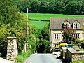
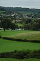
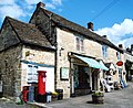
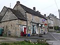
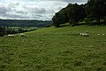
English: Uley (anciently "Yewley", rhymes with Julie) is a village in the county of Gloucestershire, England. It is situated in a wooded valley in the Cotswold escarpment, on the road between Dursley and Stroud. The population is around 1,100, but was much greater during the early years of the industrial revolution, when the village was renowned for producing blue cloth. The placename (recorded as Euuelege in the Domesday Book) probably signifies 'clearing in a yew wood'.
Subcategories
This category has the following 6 subcategories, out of 6 total.
Media in category "Uley"
The following 200 files are in this category, out of 215 total.
(previous page) (next page)-
 A very solid bus shelter, Uley - geograph.org.uk - 5642157.jpg 1,119 × 1,600; 846 KB
-
 A view down Fiery Lane, Uley - geograph.org.uk - 438419.jpg 640 × 480; 165 KB
-
 A view near Uley towards the Severn - geograph.org.uk - 438435.jpg 640 × 427; 81 KB
-
 Approach to Uley - geograph.org.uk - 1937912.jpg 640 × 480; 129 KB
-

-
 Baleful barn - geograph.org.uk - 321169.jpg 614 × 459; 124 KB
-
 Bowcott Knoll Wood - geograph.org.uk - 1479912.jpg 426 × 640; 118 KB
-
 Boxing Day Snow in Uley - geograph.org.uk - 2007611.jpg 600 × 800; 121 KB
-
 Bridleway - geograph.org.uk - 196794.jpg 450 × 600; 126 KB
-
 Bus shelter by B4066, Rockstowes - geograph.org.uk - 5642347.jpg 1,600 × 1,198; 636 KB
-
 Coaley Wood towards Hodgecombe Farm - geograph.org.uk - 3446397.jpg 800 × 600; 144 KB
-
 Come on, you took the easy route - geograph.org.uk - 3446539.jpg 800 × 600; 176 KB
-
 Communications on the edge of Uley - geograph.org.uk - 5642340.jpg 1,441 × 1,600; 767 KB
-
 Cotswold Way, Uley, Gloucestershire 2014 - geograph.org.uk - 5823665.jpg 3,872 × 2,592; 2.2 MB
-
 Crawley Hill (Hetty Pegler's Tump) - geograph.org.uk - 4408050.jpg 3,072 × 2,304; 4.1 MB
-
 Dauncey's Mill, Uley - geograph.org.uk - 6090709.jpg 640 × 427; 150 KB
-
 Daylight fades over Uleybury - Uley, Gloucestershire - geograph.org.uk - 3979622.jpg 3,072 × 2,304; 1.49 MB
-
 Downham Hill - geograph.org.uk - 1476407.jpg 640 × 426; 78 KB
-
 Downham Hill - geograph.org.uk - 1477095.jpg 640 × 426; 85 KB
-
 Downham Hill - geograph.org.uk - 1477114.jpg 640 × 426; 81 KB
-
 Downham Hill - geograph.org.uk - 427490.jpg 640 × 480; 92 KB
-
 Downham Hill - geograph.org.uk - 4408064.jpg 3,072 × 2,304; 4.14 MB
-
 Downham Hill - geograph.org.uk - 5555921.jpg 3,264 × 2,448; 3.16 MB
-
 Downham Hill from Uley Bury, Uley, Gloucestershire 2014 - geograph.org.uk - 5823815.jpg 3,461 × 2,196; 1.49 MB
-
 Entrance to Uley Long Barrow in 1981 - geograph.org.uk - 3947230.jpg 800 × 663; 154 KB
-

-
 Evening shadow - Uley, Gloucestershire - geograph.org.uk - 3971044.jpg 3,072 × 2,304; 1.96 MB
-
 Farm track near Uleyfield - geograph.org.uk - 5064482.jpg 6,000 × 4,000; 4.29 MB
-
 Farmhouse, Lye Farm - geograph.org.uk - 1479899.jpg 640 × 426; 71 KB
-
 Farmland at Mutterall Farm - geograph.org.uk - 1478652.jpg 640 × 426; 62 KB
-
 Field boundary east of Hetty Pegler's Tump - geograph.org.uk - 5856980.jpg 1,600 × 1,200; 852 KB
-
 Field near to Uley Long Barrow - geograph.org.uk - 3336720.jpg 640 × 480; 77 KB
-
 Fiery Lane Sign, Uley, Gloucestershire 2014 - geograph.org.uk - 5823670.jpg 3,872 × 2,592; 2.37 MB
-
 Fiery Lane, Uley, Gloucestershire 2014 - geograph.org.uk - 5823673.jpg 3,872 × 2,592; 1.92 MB
-
 Fiery Lane, Uley, Gloucestershire 2014 - geograph.org.uk - 5823676.jpg 3,872 × 1,609; 1.64 MB
-
 Folly Wood - geograph.org.uk - 1479915.jpg 640 × 426; 129 KB
-
 Folly Wood - geograph.org.uk - 1479918.jpg 426 × 640; 129 KB
-
 Footpath junction on Farfield road - geograph.org.uk - 5488225.jpg 3,776 × 2,520; 4.18 MB
-
 Footpath near Uleyfield - geograph.org.uk - 5064473.jpg 6,000 × 4,000; 4.67 MB
-
 Footpath sign east of Rockstowes, Uley - geograph.org.uk - 5642346.jpg 1,600 × 1,200; 826 KB
-
 Former quarries in Coaley Wood (geograph 3446390).jpg 800 × 600; 169 KB
-
 Former quarry, near Crawley Hill, Uley, Gloucestershire - 1.jpg 4,096 × 1,940; 2.7 MB
-
 Former quarry, near Crawley Hill, Uley, Gloucestershire - 2.jpg 1,940 × 2,587; 2.46 MB
-
 Gated entrance to Hetty Pegler's Tump - geograph.org.uk - 4405260.jpg 800 × 451; 140 KB
-
 Green, Uley, Gloucestershire 2014 - geograph.org.uk - 5823482.jpg 3,872 × 2,592; 2.31 MB
-
 Hetty Pegler's Tump (Uley Long Barrow) - geograph.org.uk - 5849164.jpg 1,600 × 1,200; 772 KB
-
 Hetty Pegler's Tump (Uley Long Barrow) - geograph.org.uk - 5856983.jpg 1,600 × 1,200; 741 KB
-
 Hetty Pegler's Tump - geograph.org.uk - 5796668.jpg 2,048 × 1,536; 1.25 MB
-
 Hetty Pegler's Tump - geograph.org.uk - 5856970.jpg 1,600 × 1,200; 929 KB
-
 House below the Cotswold escarpment - geograph.org.uk - 1476482.jpg 426 × 640; 109 KB
-
 Houses in Uley - geograph.org.uk - 428063.jpg 640 × 480; 102 KB
-
 Houses, Main Street, Uley, Gloucestershire 2014 - geograph.org.uk - 5823581.jpg 3,872 × 2,592; 2.13 MB
-
 Houses, Main Street, Uley, Gloucestershire 2014 - geograph.org.uk - 5823587.jpg 3,872 × 2,592; 2.18 MB
-
 Houses, Main Street, Uley, Gloucestershire 2014 - geograph.org.uk - 5823590.jpg 3,872 × 2,592; 2.14 MB
-
 I win - geograph.org.uk - 3446535.jpg 800 × 600; 196 KB
-
 Inside Hetty Pegler's Tump - geograph.org.uk - 5796670.jpg 2,048 × 1,536; 689 KB
-
 Lampern Hill, west of Uley - geograph.org.uk - 5642341.jpg 1,600 × 1,200; 826 KB
-
 Lebanon cedar at Stouts Hill - geograph.org.uk - 316736.jpg 480 × 640; 144 KB
-
 Lye Farm - geograph.org.uk - 1479730.jpg 426 × 640; 68 KB
-
 Main Street, Uley, Gloucestershire 2014 - geograph.org.uk - 5822714.jpg 3,872 × 1,538; 1.67 MB
-
 Main Street, Uley, Gloucestershire 2014 - geograph.org.uk - 5822716.jpg 3,872 × 1,803; 1.62 MB
-
 Main Street, Uley, Gloucestershire 2014 - geograph.org.uk - 5822717.jpg 3,872 × 1,655; 1.37 MB
-
 Main Street, Uley, Gloucestershire 2014 - geograph.org.uk - 5822719.jpg 3,872 × 2,592; 2.3 MB
-
 Main Street, Uley, Gloucestershire 2014 - geograph.org.uk - 5822720.jpg 3,872 × 2,592; 2.28 MB
-
 Main Street, Uley, Gloucestershire 2014 - geograph.org.uk - 5822723.jpg 3,872 × 2,592; 2.3 MB
-
 Main Street, Uley, Gloucestershire 2014 - geograph.org.uk - 5822726.jpg 3,872 × 1,635; 1.25 MB
-
 Main Street, Uley, Gloucestershire 2014 - geograph.org.uk - 5822729.jpg 3,872 × 2,592; 2.33 MB
-
 Main Street, Uley, Gloucestershire 2014 - geograph.org.uk - 5822735.jpg 3,872 × 2,592; 3.12 MB
-
 Main Street, Uley, Gloucestershire 2014 - geograph.org.uk - 5823475.jpg 3,872 × 2,592; 2.2 MB
-
 Main Street, Uley, Gloucestershire 2014 - geograph.org.uk - 5823522.jpg 3,872 × 2,592; 2.06 MB
-
 Manure heap in a field - geograph.org.uk - 3336734.jpg 640 × 480; 82 KB
-

-
 Metal gate by access road to Lye Farm near Uley - geograph.org.uk - 3275033.jpg 1,600 × 1,111; 453 KB
-
 No 8 The Green, Uley, Gloucestershire 2014 - geograph.org.uk - 5823552.jpg 3,872 × 2,592; 2.22 MB
-
 Nympsfield covered reservoir - geograph.org.uk - 5849162.jpg 1,600 × 1,200; 783 KB
-
 Old Boundary Marker - geograph.org.uk - 6437110.jpg 768 × 1,024; 205 KB
-
 Old Boundary Marker - geograph.org.uk - 6437124.jpg 893 × 893; 295 KB
-
 Old Boundary Marker - geograph.org.uk - 6439105.jpg 768 × 1,024; 338 KB
-

-
 Old Fuel Pumps, Main Street, Uley, Gloucestershire 2014 - geograph.org.uk - 5823579.jpg 3,872 × 2,592; 2.09 MB
-
 Old Fuel Pumps, Main Street, Uley, Gloucestershire 2014 - geograph.org.uk - 5823583.jpg 3,872 × 2,592; 2.02 MB
-
 Ordnance Survey Cut Mark - geograph.org.uk - 4850447.jpg 480 × 640; 125 KB
-
 Passageway inside Uley Long Barrow - geograph.org.uk - 3336686.jpg 3,488 × 2,616; 2.04 MB
-
 Path on West Hill in winter - geograph.org.uk - 6017268.jpg 1,536 × 2,048; 1.7 MB
-
 Post Office at Uley, Gloucestershire March 2008. (2369198442).jpg 1,280 × 960; 231 KB
-
 Prema Arts Centre at Bethesda Chapel, Uley - geograph.org.uk - 3882579.jpg 1,024 × 585; 232 KB
-
 Public Bridleway sign post.jpg 3,455 × 2,101; 1 MB
-
 Public Footpath sign.jpg 885 × 2,211; 759 KB
-
 Road junction in Uley - geograph.org.uk - 5642167.jpg 1,600 × 1,200; 707 KB
-
 Roadside houses, Uley - geograph.org.uk - 1478673.jpg 640 × 426; 68 KB
-
 Rook Wood - geograph.org.uk - 5073258.jpg 3,264 × 2,448; 3.59 MB
-
 Site of Uley Wash Pool - geograph.org.uk - 5646767.jpg 4,032 × 3,024; 4.81 MB
-
 Slopes of Downham Hill - geograph.org.uk - 1477102.jpg 640 × 426; 79 KB
-
 St Giles Church ^ War Memorial, Uley, Gloucestershire 2014 - geograph.org.uk - 5823548.jpg 3,872 × 2,592; 2.29 MB
-
 St Giles Church, Uley, Gloucestershire 2014 - geograph.org.uk - 5823546.jpg 3,872 × 2,592; 2.17 MB
-
 St Giles Church, Uley, Gloucestershire 2014 - geograph.org.uk - 5823547.jpg 3,872 × 1,782; 1.28 MB
-
 St Giles Church, Uley, Gloucestershire 2014 - geograph.org.uk - 5823703.jpg 3,872 × 2,592; 2.33 MB
-
 St Giles Churchyard, Uley, Gloucestershire 2014 - geograph.org.uk - 5823691.jpg 3,872 × 2,592; 2.39 MB
-
 St Giles Churchyard, Uley, Gloucestershire 2014 - geograph.org.uk - 5823694.jpg 3,872 × 2,592; 2.38 MB
-
 St Giles Churchyard, Uley, Gloucestershire 2014 - geograph.org.uk - 5823695.jpg 3,872 × 2,592; 2.32 MB
-
 St Giles Churchyard, Uley, Gloucestershire 2014 - geograph.org.uk - 5823697.jpg 1,024 × 685; 206 KB
-
 St Giles Churchyard, Uley, Gloucestershire 2014 - geograph.org.uk - 5823698.jpg 3,872 × 2,592; 2.36 MB
-
 St Giles Churchyard, Uley, Gloucestershire 2014 - geograph.org.uk - 5823701.jpg 3,872 × 2,592; 2.35 MB
-
 St Giles Churchyard, Uley, Gloucestershire 2014 - geograph.org.uk - 5823702.jpg 3,872 × 2,592; 2.37 MB
-
 St Giles' Church - Uley, Gloucestershire - geograph.org.uk - 5915215.jpg 1,024 × 661; 119 KB
-
 St Giles', Uley - geograph.org.uk - 3379060.jpg 721 × 1,024; 221 KB
-
 St Giles, Uley - geograph.org.uk - 3921565.jpg 6,016 × 4,000; 4.09 MB
-
 St Giles, Uley - geograph.org.uk - 3921585.jpg 5,111 × 3,342; 2.93 MB
-
 St Giles, Uley - geograph.org.uk - 3921591.jpg 5,891 × 3,918; 6 MB
-
 St Giles, Uley - geograph.org.uk - 3924825.jpg 5,857 × 3,815; 4.23 MB
-
 St.Giles Church - geograph.org.uk - 5071769.jpg 3,264 × 2,448; 2.69 MB
-
 Stables and barns - geograph.org.uk - 196770.jpg 600 × 450; 88 KB
-
 Steep snowy track into The Grove at Crawley - geograph.org.uk - 5641457.jpg 1,600 × 1,334; 948 KB
-
 Stone Bus Shelter, Main Street, Uley, Gloucestershire 2014 - geograph.org.uk - 5823560.jpg 3,872 × 2,592; 2.36 MB
-
 Stouts Hill - geograph.org.uk - 1479908.jpg 426 × 640; 68 KB
-
 Stouts Hill - geograph.org.uk - 6344013.jpg 1,600 × 900; 874 KB
-
 The 'Old Crown' at Uley - geograph.org.uk - 1937933.jpg 640 × 480; 80 KB
-
 The 1st fairway - geograph.org.uk - 381464.jpg 640 × 480; 118 KB
-
 The B4058 after a shower - geograph.org.uk - 381470.jpg 640 × 480; 129 KB
-

-
 The church of St Giles, Uley - geograph.org.uk - 5642151.jpg 1,600 × 1,333; 907 KB
-
 The Cotswold Way at Hodgecombe Farm - geograph.org.uk - 3446411.jpg 800 × 600; 154 KB
-
 The Cotswold way heading towards Uley Bury - geograph.org.uk - 5489920.jpg 3,776 × 2,520; 4.02 MB
-
 The Cotswold Way to Cam Long Down - geograph.org.uk - 5064487.jpg 6,000 × 4,000; 4.74 MB
-
 The Cotswold Way to Dursley - geograph.org.uk - 5064492.jpg 6,000 × 4,000; 4.68 MB
-
 The Cotswold Way towards Cam Long Down - geograph.org.uk - 3446418.jpg 800 × 600; 178 KB
-
 The Cotswold Way towards Hodgecombe Farm - geograph.org.uk - 3446400.jpg 800 × 600; 155 KB
-
 The diminutive River Ewelme - geograph.org.uk - 6344011.jpg 1,600 × 900; 1.08 MB
-
 The eastern portal of Hetty Pegler's Tump - geograph.org.uk - 5849168.jpg 1,600 × 1,200; 816 KB
-
 The Gables, Main Street, Uley, Gloucestershire 2014 - geograph.org.uk - 5823570.jpg 3,872 × 2,592; 2.15 MB
-
 The Green ^ Main Street, Uley, Gloucestershire 2014 - geograph.org.uk - 5823483.jpg 3,872 × 1,706; 2.15 MB
-
 The Green ^ Main Street, Uley, Gloucestershire 2014 - geograph.org.uk - 5823489.jpg 3,872 × 2,592; 2.14 MB
-
 The Green ^ Old Crown Pub, Uley, Gloucestershire 2014 - geograph.org.uk - 5823517.jpg 3,872 × 2,592; 2.24 MB
-
 The Green, Uley, Gloucestershire 2014 - geograph.org.uk - 5823532.jpg 3,872 × 2,592; 2.26 MB
-
 The Green, Uley, Gloucestershire 2014 - geograph.org.uk - 5823534.jpg 3,872 × 2,592; 2.23 MB
-
 The Grove - geograph.org.uk - 427483.jpg 480 × 640; 115 KB
-
 The Old Crown - geograph.org.uk - 4927466.jpg 3,264 × 2,448; 2.63 MB
-
 The Old Crown - geograph.org.uk - 5071768.jpg 3,264 × 2,448; 2.35 MB
-
 The Old Crown Pub, Uley, Gloucestershire 2014 - geograph.org.uk - 5823485.jpg 2,974 × 1,983; 1.07 MB
-
 The Old Crown Pub, Uley, Gloucestershire 2014 - geograph.org.uk - 5823487.jpg 3,872 × 2,592; 2.36 MB
-
 The Old Crown Sign, Uley, Gloucestershire 2014 - geograph.org.uk - 5823526.jpg 3,120 × 2,080; 961 KB
-
 The Old Crown ^ St Giles Church, Uley, Gloucestershire 2014 - geograph.org.uk - 5823478.jpg 3,872 × 2,592; 2.12 MB
-
 The Old Crown, Uley - geograph.org.uk - 5641472.jpg 1,600 × 1,280; 853 KB
-
 The Old Crown, Uley, Gloucestershire 2014 - geograph.org.uk - 5823506.jpg 3,872 × 2,592; 2.99 MB
-
 The Old Crown, Uley, Gloucestershire 2014 - geograph.org.uk - 5823512.jpg 3,872 × 2,592; 4.01 MB
-
 The Old Crown, Uley, Gloucestershire 2014 - geograph.org.uk - 5823530.jpg 3,872 × 1,777; 2.73 MB
-
 The Old Crown, Uley, Gloucestershire 2014 - geograph.org.uk - 5823536.jpg 3,872 × 2,592; 2.76 MB
-
 The road to Uley - geograph.org.uk - 774050.jpg 640 × 480; 148 KB
-
 The Street, Uley - geograph.org.uk - 3275034.jpg 800 × 632; 122 KB
-
 Track in Coaley Wood - geograph.org.uk - 5061939.jpg 6,000 × 4,000; 5.14 MB
-
 Uley - geograph.org.uk - 1479726.jpg 640 × 426; 81 KB
-
 Uley Brewery - geograph.org.uk - 428073.jpg 480 × 640; 105 KB
-
 Uley Bury Iron Age Hill Fort - geograph.org.uk - 5456863.jpg 3,264 × 2,448; 2.99 MB
-

-

-

-

-

-

-

-
 Uley churchyard - geograph.org.uk - 3274119.jpg 1,024 × 776; 196 KB
-
 Uley Long Barrow - geograph.org.uk - 3336696.jpg 3,488 × 2,616; 2.17 MB
-
 Uley Long Barrow or Hetty Pegler's Tump - geograph.org.uk - 3336658.jpg 3,488 × 2,616; 2.25 MB
-
 Uley viewed across fields - geograph.org.uk - 1479895.jpg 640 × 426; 62 KB
-
 Uley Village from Uley Bury, Gloucestershire 2014 - geograph.org.uk - 5823797.jpg 3,282 × 1,191; 1,012 KB
-
 Uley Village from Uley Bury, Gloucestershire 2014 - geograph.org.uk - 5823829.jpg 3,801 × 2,444; 2.29 MB
-
 Uley Village Green.JPG 2,816 × 2,120; 1.52 MB
-
 Uley village hall - geograph.org.uk - 6344016.jpg 1,600 × 901; 536 KB
-

-
 Uley, disused petrol pumps - geograph.org.uk - 2288009.jpg 480 × 640; 90 KB
-
 Uley, Gloucestershire ... post office and store May 2010. (4615734960).jpg 2,782 × 2,266; 4.09 MB
-
 Uley, Old Crown - geograph.org.uk - 1810957.jpg 1,024 × 789; 160 KB
-
 Uley, pathway - geograph.org.uk - 1810932.jpg 1,024 × 768; 221 KB
-
 Uley, postbox № GL11 114 - geograph.org.uk - 2288002.jpg 480 × 640; 94 KB
-
-
 Uleybury evening sunshine - Uley, Gloucestershire - geograph.org.uk - 3970404.jpg 3,072 × 2,304; 2.43 MB
-

-
 Uleybury seat in the evening - Uley, Gloucestershire - geograph.org.uk - 3971025.jpg 3,072 × 2,304; 1.99 MB
-
 Valley above Uley - geograph.org.uk - 1478647.jpg 640 × 426; 72 KB
-
 View across the Uley valley - geograph.org.uk - 1477096.jpg 640 × 426; 74 KB
-
 View of Uley 2005.jpg 576 × 295; 33 KB
-
 View of Uley from Uley Bury - geograph.org.uk - 2007605.jpg 800 × 600; 110 KB
-
 View to Stouts Hill - geograph.org.uk - 1479901.jpg 640 × 426; 68 KB
-
 View towards Uley - geograph.org.uk - 5566130.jpg 3,264 × 2,448; 2.55 MB
-
 Village Hall, Main Street, Uley, Gloucestershire 2014 - geograph.org.uk - 5823565.jpg 3,872 × 2,592; 2.11 MB
-

-

-

-

-

-

-

-
 Walking towards Dursley - geograph.org.uk - 3446542.jpg 800 × 600; 176 KB
-
 Wall painting at Uley - geograph.org.uk - 1477105.jpg 426 × 640; 118 KB
-
 Walled Postbox, The Green, Uley, Gloucestershire 2014 - geograph.org.uk - 5823555.jpg 3,872 × 2,592; 2.36 MB
-
 Water Reservoir - geograph.org.uk - 4408057.jpg 3,072 × 2,304; 3.63 MB
-
 Bowcott farm - geograph.org.uk - 321179.jpg 627 × 410; 83 KB
-
 Bowcott Lodge - geograph.org.uk - 321175.jpg 640 × 480; 110 KB
-
 Bridleway to Uley Bury - geograph.org.uk - 1477090.jpg 640 × 426; 89 KB
-
 Cam Long Down - geograph.org.uk - 1476467.jpg 426 × 640; 87 KB


_-_geograph.org.uk_-_4408050.jpg)


.jpg)


_-_geograph.org.uk_-_5849164.jpg)
_-_geograph.org.uk_-_5856983.jpg)


.jpg)


.jpg)


