Category:United Kingdom photographs taken on 2007-08-03
Countries of Europe: Austria · Belarus · Belgium · Bulgaria · Croatia · Czech Republic · Finland · France‡ · Germany · Greece · Hungary · Iceland · Republic of Ireland · Italy · Montenegro · Netherlands‡ · Norway · Poland · Portugal‡ · Romania · Russia‡ · Serbia · Slovakia · Spain‡ · Sweden · Switzerland · Turkey‡ · Ukraine · United Kingdom
‡: partly located in Europe
‡: partly located in Europe
| ← | 3 August 2007 | → | ||
| ← | August 2007 | → | ||

United Kingdom photographs taken on 3 August 2007.
Image files should be categorized here automatically using {{taken on}} template. Direct categorisation is also possible, if automatic is impossible.
Subcategories
This category has the following 3 subcategories, out of 3 total.
S
Media in category "United Kingdom photographs taken on 2007-08-03"
The following 200 files are in this category, out of 689 total.
(previous page) (next page)-
 "The Great Barn" at Hempstead - geograph.org.uk - 515733.jpg 640 × 480; 151 KB
-
 215 Miles from Southport - geograph.org.uk - 515415.jpg 640 × 452; 79 KB
-
-
 A foal - geograph.org.uk - 515191.jpg 640 × 480; 120 KB
-
 A sheep feeder at Bronasgellog - geograph.org.uk - 517685.jpg 640 × 480; 111 KB
-
 A two way seat for two. - geograph.org.uk - 514513.jpg 480 × 640; 130 KB
-
 A174 near Staithes - geograph.org.uk - 515014.jpg 640 × 480; 105 KB
-
 Across the Tay to the Carse of Gowrie - geograph.org.uk - 522121.jpg 640 × 480; 91 KB
-
 Afon Prysor below Pont Trawsfynydd - geograph.org.uk - 516951.jpg 640 × 480; 69 KB
-
 Afon Prysor upstream of Pont Trawsfynydd - geograph.org.uk - 516949.jpg 640 × 480; 108 KB
-
 Aglais io - geograph.org.uk - 514533.jpg 640 × 427; 41 KB
-
 Aglais io, Thetford Forest - geograph.org.uk - 514474.jpg 640 × 427; 67 KB
-
 Aldi Supermarket, Sudbury - geograph.org.uk - 522727.jpg 640 × 480; 91 KB
-
 Allerford - Approaching ford and bridge - geograph.org.uk - 531895.jpg 640 × 480; 119 KB
-
 Anglian Water Cadney Intake - geograph.org.uk - 515020.jpg 640 × 457; 100 KB
-

-
-
 Armoury House - geograph.org.uk - 514723.jpg 640 × 533; 90 KB
-
 Arthur House on the Golden Lane Estate.jpg 2,136 × 2,848; 1.82 MB
-
 Astley County Primary School - geograph.org.uk - 515844.jpg 640 × 480; 108 KB
-
 B3231 towards Braunton - geograph.org.uk - 522552.jpg 640 × 425; 65 KB
-
 Baconsthorpe street scene - geograph.org.uk - 515696.jpg 640 × 480; 146 KB
-
 Ballingdon Street, looking east - geograph.org.uk - 563990.jpg 640 × 480; 130 KB
-
 Bank Street.jpg 640 × 510; 85 KB
-
 Barley at Powgavie - geograph.org.uk - 514864.jpg 640 × 426; 99 KB
-
 Barley, Tynehead - geograph.org.uk - 514393.jpg 639 × 467; 59 KB
-
 Barn at Sand Hills - geograph.org.uk - 515005.jpg 640 × 426; 127 KB
-
 Barringtoncourt1.jpg 640 × 480; 230 KB
-

-
 Beetham tower Manchester - geograph.org.uk - 514640.jpg 640 × 425; 80 KB
-
 Beverley Westwood Common Land - geograph.org.uk - 514559.jpg 640 × 480; 99 KB
-
 Beverley Westwood Common Land - geograph.org.uk - 514560.jpg 640 × 480; 105 KB
-
 Beverley Westwood Copse - geograph.org.uk - 514767.jpg 640 × 480; 96 KB
-
 Beverley Westwood Golf Course - geograph.org.uk - 514570.jpg 640 × 480; 89 KB
-
 Beverley Westwood Houses - geograph.org.uk - 514779.jpg 640 × 421; 77 KB
-
 Beverley Westwood Lightning Tree - geograph.org.uk - 514765.jpg 640 × 480; 79 KB
-
 Birds Hurst, Thetford Forest - geograph.org.uk - 514438.jpg 640 × 427; 121 KB
-
 Black Isle Brewery - geograph.org.uk - 527198.jpg 640 × 480; 78 KB
-

-

-
 Boulder clay on the beach - geograph.org.uk - 514993.jpg 640 × 427; 156 KB
-

-
 Bowling Hall - geograph.org.uk - 514507.jpg 640 × 480; 97 KB
-
 Brandon Park - geograph.org.uk - 514562.jpg 640 × 427; 124 KB
-
 Braunton Burrows and Saunton Sands - geograph.org.uk - 820279.jpg 640 × 425; 38 KB
-
 Bridge Lane, Cadney - geograph.org.uk - 514557.jpg 640 × 426; 98 KB
-
 Bridge Street - geograph.org.uk - 570380.jpg 640 × 480; 132 KB
-
 Brixham Harbour - geograph.org.uk - 516969.jpg 640 × 480; 109 KB
-
 Broad Beans - geograph.org.uk - 516102.jpg 640 × 426; 161 KB
-
 Broad Sands - geograph.org.uk - 817844.jpg 640 × 425; 58 KB
-
 Bronasgellog - geograph.org.uk - 517703.jpg 640 × 420; 93 KB
-
 Brunswick Place - Eastern Side - geograph.org.uk - 514566.jpg 479 × 640; 123 KB
-
 Brunswick Place - Western Side - geograph.org.uk - 514569.jpg 441 × 640; 133 KB
-
 Brunswick Street East - geograph.org.uk - 514621.jpg 479 × 640; 125 KB
-
 Buckingham Palace viewed from St. James's Park.jpg 2,272 × 1,704; 1.74 MB
-
 Bus exchange - geograph.org.uk - 834644.jpg 640 × 457; 308 KB
-
 Bus shelter at Helwith Bridge - geograph.org.uk - 1440432.jpg 640 × 480; 117 KB
-
 Busy turning down to Salthouse - geograph.org.uk - 515798.jpg 640 × 480; 138 KB
-
 Butts Ash electricity substation - geograph.org.uk - 515944.jpg 640 × 435; 190 KB
-
 Butts Ash electricity substation - geograph.org.uk - 515950.jpg 640 × 433; 184 KB
-
 Cadney Bridge - geograph.org.uk - 515015.jpg 640 × 426; 128 KB
-
 Cakemuir - geograph.org.uk - 514387.jpg 640 × 480; 73 KB
-
 Cakemuir Burn - geograph.org.uk - 514385.jpg 640 × 480; 67 KB
-
 Camping field at Helwith Bridge - geograph.org.uk - 1440222.jpg 640 × 480; 128 KB
-
 Cattle at Bryn-celynog - geograph.org.uk - 518000.jpg 640 × 399; 94 KB
-
-
 Caves below Cowbar Lane - geograph.org.uk - 515114.jpg 640 × 480; 104 KB
-
 Chapel Hill near Wolfsdale - geograph.org.uk - 520994.jpg 640 × 480; 50 KB
-
 Church Street from the church steps - geograph.org.uk - 515030.jpg 640 × 480; 352 KB
-
 Coastal erosion - geograph.org.uk - 514965.jpg 640 × 389; 96 KB
-
 Coire Loch in Glen Affric - geograph.org.uk - 1110394.jpg 640 × 480; 98 KB
-
 Combs Dike at Helwith Bridge - geograph.org.uk - 1440204.jpg 640 × 480; 152 KB
-
 Corfe Castle railway station 1.JPG 2,160 × 1,440; 817 KB
-
 Corfe Castle railway station 2.JPG 2,160 × 1,440; 831 KB
-
 Corn Exchange, High Street - geograph.org.uk - 515053.jpg 640 × 454; 318 KB
-
 Corn harvest - geograph.org.uk - 514804.jpg 640 × 427; 76 KB
-
 Cornerstone, Hythe United Reformed Church - geograph.org.uk - 515931.jpg 640 × 427; 156 KB
-
 Cressey Yard, Brigg - geograph.org.uk - 514692.jpg 481 × 640; 160 KB
-
 Cross Foxes, Trawsfynydd.jpg 640 × 480; 78 KB
-
 Cwm Casseg - geograph.org.uk - 515213.jpg 640 × 480; 100 KB
-
 Cycle path - geograph.org.uk - 515097.jpg 640 × 480; 57 KB
-
 Dalehouse - geograph.org.uk - 515018.jpg 640 × 480; 121 KB
-
 Dam Street, Lichfield - geograph.org.uk - 519254.jpg 640 × 428; 89 KB
-
 Decorations - geograph.org.uk - 515058.jpg 480 × 601; 98 KB
-
 Derelict House - geograph.org.uk - 514720.jpg 640 × 426; 142 KB
-
 Drive to Newstead Farm - geograph.org.uk - 514260.jpg 640 × 480; 104 KB
-
 Dry Mere on Clegg Moor - geograph.org.uk - 648342.jpg 640 × 480; 44 KB
-
-

-
 East Lodge Wassand Hall.jpg 640 × 471; 116 KB
-
 Edenfield Cemetery Hornsea.jpg 485 × 640; 123 KB
-
 Entrance to Lawn Farm - geograph.org.uk - 515804.jpg 640 × 480; 117 KB
-
 Entrance to rifle range. - geograph.org.uk - 514716.jpg 640 × 470; 183 KB
-
 Entry into the Llafar Valley loop - geograph.org.uk - 518549.jpg 640 × 359; 60 KB
-

-
 Fairlinch Cross - geograph.org.uk - 522543.jpg 640 × 425; 88 KB
-
 Fairview Parade, Hythe - geograph.org.uk - 515933.jpg 640 × 427; 149 KB
-
 Falcon Clints - geograph.org.uk - 1690481.jpg 640 × 480; 58 KB
-
 Falcon Square Statue - geograph.org.uk - 518381.jpg 408 × 600; 30 KB
-
 Falcon Square.jpg 478 × 600; 48 KB
-

-
 Farm buildings at Upwood Farm - geograph.org.uk - 515685.jpg 640 × 407; 54 KB
-
 Farmhouse of Newton, Costa - geograph.org.uk - 514431.jpg 640 × 411; 95 KB
-

-
 Fault-guided valley - geograph.org.uk - 517962.jpg 640 × 361; 57 KB
-
 Fell Dike Sike - geograph.org.uk - 1690572.jpg 640 × 480; 97 KB
-
 Ffermdy Bronasgellog Farmhouse - geograph.org.uk - 516740.jpg 640 × 480; 123 KB
-
 Ffermdy Bryn Goleu Farmhouse - geograph.org.uk - 517750.jpg 640 × 532; 93 KB
-
 Fields at the Leys - geograph.org.uk - 514874.jpg 640 × 426; 83 KB
-
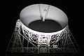
 First Light, Jodrell Bank 02.jpg 3,888 × 2,592; 2.98 MB
-
 First Light, Jodrell Bank 03.jpg 3,888 × 2,592; 3.55 MB
-
 First Light, Jodrell Bank 04.jpg 3,888 × 2,592; 2.06 MB
-
 First Light, Jodrell Bank 05.jpg 3,888 × 2,592; 2.59 MB
-
 First Light, Jodrell Bank 06.jpg 3,888 × 2,592; 2.51 MB
-
 First Light, Jodrell Bank 07.jpg 3,888 × 2,592; 1.3 MB
-
 First Light, Jodrell Bank 08.jpg 3,888 × 2,592; 1.78 MB
-
 First Light, Jodrell Bank 09.jpg 3,888 × 2,592; 1.85 MB
-
 First Light, Jodrell Bank 10.jpg 3,888 × 2,592; 1.69 MB
-
 First Light, Jodrell Bank 11.jpg 3,888 × 2,592; 1.7 MB
-
 First Light, Jodrell Bank 12.jpg 3,888 × 2,592; 1.83 MB
-
 First Light, Jodrell Bank 13.jpg 3,888 × 2,592; 1.7 MB
-
 Fishing lake at Victoria Park, Bow - geograph.org.uk - 515128.jpg 640 × 480; 139 KB
-
 Flats on Battersea Reach - geograph.org.uk - 532721.jpg 640 × 480; 90 KB
-
 Foel Grach from Gwaun y Garnedd - geograph.org.uk - 515253.jpg 640 × 480; 72 KB
-

-
 Footbridge - geograph.org.uk - 514658.jpg 640 × 425; 119 KB
-
 Footbridge on the Lelley to Preston Path - geograph.org.uk - 514797.jpg 640 × 480; 101 KB
-
 Footbridge over Nant Budr - geograph.org.uk - 518308.jpg 640 × 480; 129 KB
-
 Footbridge over River Brant - geograph.org.uk - 514809.jpg 640 × 480; 125 KB
-
 Footpath through Burton Bushes - geograph.org.uk - 514760.jpg 640 × 480; 161 KB
-
 Footpath to Lelley - geograph.org.uk - 514783.jpg 640 × 480; 123 KB
-
 Ford - geograph.org.uk - 923753.jpg 640 × 480; 98 KB
-
 Ford and falls - geograph.org.uk - 923754.jpg 640 × 480; 117 KB
-
 Ford and falls - geograph.org.uk - 923755.jpg 640 × 480; 118 KB
-
 Forest Road summit, near Colt Hill. - geograph.org.uk - 514771.jpg 640 × 480; 85 KB
-
 Fork in road - geograph.org.uk - 923749.jpg 640 × 480; 59 KB
-
 Former railway embankment - geograph.org.uk - 517841.jpg 640 × 355; 62 KB
-
 Frankenbury camp geograph-514585-by-Barry-Deakin.jpg 640 × 480; 207 KB
-
 Frankenbury Camp geograph-514599-by-Barry-Deakin.jpg 640 × 480; 129 KB
-
 Friars Bridge.jpg 640 × 480; 86 KB
-
 Fungi on a dead Scots Pine - geograph.org.uk - 1110395.jpg 640 × 480; 138 KB
-
 Gaia Melon (1016454281).jpg 1,270 × 848; 318 KB
-
 Gailey Wharf - geograph.org.uk - 515013.jpg 640 × 428; 102 KB
-
 Garden at Salisbury Hospice - geograph.org.uk - 515687.jpg 640 × 629; 209 KB
-
-

-
 Gerston Chapel Paignton - geograph.org.uk - 519196.jpg 640 × 480; 120 KB
-
 Girder Road Bridge - geograph.org.uk - 514773.jpg 640 × 407; 91 KB
-
 Going to Hell (Hole) - near Upwood - geograph.org.uk - 521300.jpg 480 × 640; 181 KB
-
 Goxhill - geograph.org.uk - 516108.jpg 640 × 480; 121 KB
-

-

-
 Grand entrance to The Prospect - geograph.org.uk - 515016.jpg 640 × 491; 492 KB
-
 Weather Vane, St Eloy's Church. - geograph.org.uk - 531681.jpg 640 × 480; 47 KB
-
 Grover and Allen - geograph.org.uk - 523345.jpg 640 × 480; 103 KB
-
 Groyne - geograph.org.uk - 514955.jpg 640 × 427; 85 KB
-
 Hall Garth Park, Hornsea - geograph.org.uk - 515884.jpg 640 × 463; 122 KB
-
 Harberton Churchyard - geograph.org.uk - 520187.jpg 640 × 480; 105 KB
-
 Harberton, St. Andrew - geograph.org.uk - 520184.jpg 640 × 480; 76 KB
-
 Harby harvest - geograph.org.uk - 514810.jpg 640 × 427; 69 KB
-
 Hare and Hounds Inn, Baconsthorpe - geograph.org.uk - 515699.jpg 640 × 480; 110 KB
-
 Harvest in Black House Field - geograph.org.uk - 514801.jpg 640 × 427; 72 KB
-
 Harvester - geograph.org.uk - 514812.jpg 640 × 427; 57 KB
-
 Hay bales at Broomhall - geograph.org.uk - 514851.jpg 640 × 426; 90 KB
-

-
 Headwaters of the River Glaven - geograph.org.uk - 515764.jpg 480 × 640; 188 KB
-
 Helwith Bridge - geograph.org.uk - 1440257.jpg 640 × 480; 127 KB
-
 Helwith Bridge and a view to Long Lane - geograph.org.uk - 1440274.jpg 640 × 480; 101 KB
-
 Helwith Bridge and Inn - geograph.org.uk - 1440391.jpg 640 × 480; 122 KB
-

-
 Helwith Bridge water treatment works - geograph.org.uk - 1440602.jpg 640 × 480; 157 KB
-
 Henry Cubitt funerary monument.jpg 600 × 800; 242 KB
-
 Heol-y-Celyn school - geograph.org.uk - 514503.jpg 640 × 480; 102 KB
-

-
 High Wrong Corner, Thetford Forest - geograph.org.uk - 514447.jpg 640 × 427; 95 KB
-
 High Wrong Corner, Thetford Forest - geograph.org.uk - 514448.jpg 427 × 640; 121 KB
-
 High Wrong Corner, Thetford Forest - geograph.org.uk - 514451.jpg 640 × 427; 98 KB
-
 Highland Cattle - geograph.org.uk - 514344.jpg 480 × 640; 105 KB
-
 Highland Cattle - geograph.org.uk - 514346.jpg 480 × 640; 77 KB
-
 Hill slope at Y Gors - geograph.org.uk - 516733.jpg 640 × 480; 73 KB
-
 Hillside Animal Sanctuary - geograph.org.uk - 514307.jpg 480 × 640; 63 KB
-

-
 Hornsea Cottage Hospital - geograph.org.uk - 515877.jpg 640 × 475; 101 KB
-
 Hornsea Esplanade - geograph.org.uk - 515869.jpg 478 × 640; 128 KB
-
 Hornsea Prom - geograph.org.uk - 515872.jpg 523 × 640; 66 KB
-
 Hornsea Sailing Club - geograph.org.uk - 515907.jpg 640 × 471; 85 KB
-
 Horse Cove, Dawlish, Devon - geograph.org.uk - 515503.jpg 640 × 480; 130 KB
-

-

-
 HSBC Bank, Sudbury - geograph.org.uk - 521606.jpg 640 × 480; 86 KB
-
 St George's Church - geograph.org.uk - 514824.jpg 425 × 640; 104 KB
-
 St George's Church - geograph.org.uk - 514843.jpg 640 × 425; 87 KB
-
 Ilkley Cemetery - geograph.org.uk - 514630.jpg 640 × 393; 65 KB
-
 Ilkley Railway Station - geograph.org.uk - 514689.jpg 640 × 432; 50 KB
-
 Illidge Green - geograph.org.uk - 515925.jpg 640 × 480; 133 KB
-

-
 Intake for Cadney Water Plant - geograph.org.uk - 517903.jpg 640 × 426; 113 KB
-
 Invergowrie railway station 1.jpg 640 × 426; 123 KB
-
 Just visiting - geograph.org.uk - 514959.jpg 425 × 640; 126 KB
-
 Keelmans way - geograph.org.uk - 515129.jpg 640 × 480; 78 KB


.jpg)


_-_near_Upwood_-_geograph.org.uk_-_521300.jpg)


