Category:United Kingdom photographs taken on 2007-11-20
Countries of Europe: Belgium · Czech Republic · Finland · Germany · Republic of Ireland · Italy · Latvia · Netherlands‡ · Poland · Portugal‡ · Russia‡ · Spain‡ · Turkey‡ · Ukraine · United Kingdom
‡: partly located in Europe
‡: partly located in Europe
| ← | 20 November 2007 | → | ||
| ← | November 2007 | → | ||

United Kingdom photographs taken on 20 November 2007.
Image files should be categorized here automatically using {{taken on}} template. Direct categorisation is also possible, if automatic is impossible.
Subcategories
This category has the following 2 subcategories, out of 2 total.
Media in category "United Kingdom photographs taken on 2007-11-20"
The following 200 files are in this category, out of 265 total.
(previous page) (next page)-
 "Gallows Hill", Omagh - geograph.org.uk - 616332.jpg 640 × 278; 28 KB
-
 - panoramio - Shiroi Hane.jpg 1,600 × 1,200; 428 KB
-
 A682 heading towards Burnley - geograph.org.uk - 616414.jpg 640 × 425; 48 KB
-
 Across the dyke - geograph.org.uk - 616867.jpg 480 × 640; 118 KB
-
 Afon Crafnant - geograph.org.uk - 617643.jpg 640 × 480; 144 KB
-
 Allt Thormaid - geograph.org.uk - 618637.jpg 480 × 640; 135 KB
-
 Along the A682 - geograph.org.uk - 616413.jpg 640 × 425; 61 KB
-
 Arcade of shops, Deganwy - geograph.org.uk - 616514.jpg 480 × 640; 55 KB
-
 Archway on The Bailey, Skipton - geograph.org.uk - 620515.jpg 640 × 480; 207 KB
-
 Ashlea Gate - Upper Town Street - geograph.org.uk - 616971.jpg 640 × 411; 21 KB
-
 Back Bridge Street, Skipton - geograph.org.uk - 622045.jpg 480 × 640; 156 KB
-
 Bailiffscourt buildings - geograph.org.uk - 1532692.jpg 640 × 417; 62 KB
-
 Bailiffscourt Chapel, Atherington - geograph.org.uk - 1532680.jpg 640 × 482; 76 KB
-
 Bailiffscourt Folly - geograph.org.uk - 1532671.jpg 640 × 434; 106 KB
-
 Bay Horse Yard, Skipton - geograph.org.uk - 622022.jpg 640 × 480; 223 KB
-
 Bell Lane - Upper Town Street - geograph.org.uk - 616975.jpg 640 × 437; 42 KB
-
 Beyond the future - geograph.org.uk - 616415.jpg 640 × 425; 49 KB
-
 Bramley Bus Depot - Henconner Lane - geograph.org.uk - 616985.jpg 640 × 416; 27 KB
-

-
 Bricked-up bridge - geograph.org.uk - 616339.jpg 640 × 486; 105 KB
-
 Bridge over A road near High Street - geograph.org.uk - 616512.jpg 640 × 480; 66 KB
-
 Brunel Centre upper level, Swindon - geograph.org.uk - 616393.jpg 640 × 480; 331 KB
-
 Eglwys Boduan Church - geograph.org.uk - 618264.jpg 640 × 428; 86 KB
-
 Eglwys Buan Sant Boduan - geograph.org.uk - 618261.jpg 640 × 428; 81 KB
-
 Eglwys Buan Sant Boduan - geograph.org.uk - 618268.jpg 640 × 428; 94 KB
-
 Eglwys Buan Sant Boduan - geograph.org.uk - 618272.jpg 640 × 428; 72 KB
-
 Eglwys Buan Sant Boduan - geograph.org.uk - 618275.jpg 640 × 428; 86 KB
-
 Eglwys Buan Sant Boduan - geograph.org.uk - 618278.jpg 640 × 428; 84 KB
-
 Eglwys Buan Sant Boduan - geograph.org.uk - 618300.jpg 640 × 428; 96 KB
-
 Bus stop in Wet Street - geograph.org.uk - 616639.jpg 640 × 480; 65 KB
-
 St Mary's Church, Caerhun - geograph.org.uk - 617217.jpg 640 × 480; 67 KB
-
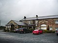
 Cambridge Toyota and Lexus - geograph.org.uk - 616380.jpg 640 × 470; 65 KB
-
 Canal boat hire, Skipton - geograph.org.uk - 622038.jpg 640 × 480; 170 KB
-
 Canal View Motors, Skipton - geograph.org.uk - 622028.jpg 640 × 480; 216 KB
-
 Capel Annibynwyr, Trefriw - geograph.org.uk - 618176.jpg 640 × 480; 89 KB
-
 Car Dealership, Conwy - geograph.org.uk - 616445.jpg 640 × 480; 50 KB
-
-
 Castle Street, Conwy - geograph.org.uk - 616539.jpg 480 × 640; 55 KB
-
 Cedar Court - geograph.org.uk - 616613.jpg 640 × 480; 64 KB
-
 Chapel Hill, Skipton - geograph.org.uk - 620600.jpg 640 × 480; 171 KB
-
 Charlbury Road community centre - geograph.org.uk - 616337.jpg 640 × 460; 92 KB
-
 Church of the Sacred Heart(R.C) - geograph.org.uk - 616710.jpg 640 × 480; 55 KB
-
 Churchyard, Gyffin - geograph.org.uk - 618182.jpg 480 × 640; 96 KB
-
 Coach Street, Skipton - geograph.org.uk - 622040.jpg 640 × 480; 182 KB
-
 Commercial, Skipton.jpg 640 × 480; 145 KB
-
 Contrasting homes in the High Street - geograph.org.uk - 616499.jpg 640 × 480; 55 KB
-
 Conwy bridges - geograph.org.uk - 616518.jpg 640 × 480; 60 KB
-
 Conwy Castle - geograph.org.uk - 616519.jpg 640 × 480; 78 KB
-
 Curious seat near Bus Station - geograph.org.uk - 616721.jpg 640 × 480; 76 KB
-
 Curlew, Deganwy shoreline - geograph.org.uk - 616454.jpg 640 × 480; 74 KB
-
 Dawn at An Claddach - geograph.org.uk - 931900.jpg 640 × 360; 43 KB
-

-
 Distillery, Bushmills, Co. Antrim (26174707572).jpg 2,000 × 1,522; 1.74 MB
-
-
 East View - West View, Omagh - geograph.org.uk - 616327.jpg 640 × 480; 84 KB
-
 East View - West View, Omagh - geograph.org.uk - 616328.jpg 640 × 299; 38 KB
-
 East window St Peters Church - geograph.org.uk - 617262.jpg 480 × 640; 107 KB
-
 Eglwys St Bened, Gyffin - geograph.org.uk - 616806.jpg 480 × 640; 89 KB
-
 Electricity - geograph.org.uk - 616411.jpg 640 × 425; 56 KB
-
-
 Ely Cathedral Octagon HDR - Flickr - edbrambley.jpg 3,888 × 2,607; 5.04 MB
-
 Falklands Arch - geograph.org.uk - 616667.jpg 640 × 480; 75 KB
-
 Fareham Bus Station - geograph.org.uk - 616718.jpg 640 × 480; 52 KB
-
 Fareham Civic Offices - geograph.org.uk - 616701.jpg 640 × 480; 66 KB
-
 Fareham Library - geograph.org.uk - 616696.jpg 640 × 480; 78 KB
-
 Fareham Police Station - geograph.org.uk - 616671.jpg 640 × 480; 49 KB
-
 Fareham Post Office - geograph.org.uk - 616684.jpg 640 × 480; 64 KB
-
 Fishing boat, Conwy - geograph.org.uk - 616522.jpg 640 × 480; 74 KB
-
 Footbridge over Eller Beck - geograph.org.uk - 620589.jpg 640 × 480; 130 KB
-
 Footpath - geograph.org.uk - 620576.jpg 640 × 480; 175 KB
-
 Footpath - geograph.org.uk - 620584.jpg 480 × 640; 169 KB
-
 Footpath to NatWest Call Centre - geograph.org.uk - 616529.jpg 640 × 480; 101 KB
-

-

-
 Former School - Broad Lane - geograph.org.uk - 616966.jpg 640 × 482; 32 KB
-
 Great Cambridge Road A10 Tottenham - geograph.org.uk - 1072094.jpg 640 × 480; 85 KB
-
 Guildhall, Conwy - geograph.org.uk - 616537.jpg 640 × 480; 72 KB
-
 Gyffin Chapel - geograph.org.uk - 616804.jpg 480 × 640; 57 KB
-
 Gym behind West Street - geograph.org.uk - 616678.jpg 640 × 480; 64 KB
-
 Heather Grove - Henconner Lane - geograph.org.uk - 616986.jpg 640 × 437; 24 KB
-
 St Mary's Church, Hemingbrough.jpg 640 × 435; 72 KB
-
 Henconner Lane - geograph.org.uk - 616984.jpg 640 × 454; 27 KB
-
 High Corn Mill, Skipton - geograph.org.uk - 620571.jpg 640 × 480; 155 KB
-
 High Corn Mill, Skipton - geograph.org.uk - 620573.jpg 640 × 480; 132 KB
-
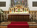 Holy Trinity Church, Skipton, Altar - geograph.org.uk - 620660.jpg 640 × 480; 190 KB
-
 Holy Trinity Church, Skipton, Altar - geograph.org.uk - 620662.jpg 480 × 640; 151 KB
-
 Holy Trinity Church, Skipton, Altar - geograph.org.uk - 620665.jpg 640 × 480; 215 KB
-
 Holy Trinity Church, Skipton, Doorway - geograph.org.uk - 620518.jpg 468 × 626; 191 KB
-
 Holy Trinity Church, Skipton, Font - geograph.org.uk - 620606.jpg 480 × 640; 196 KB
-
 Holy Trinity Church, Skipton, Interior - geograph.org.uk - 620607.jpg 640 × 480; 183 KB
-
 Holy Trinity Church, Skipton, Interior - geograph.org.uk - 620667.jpg 640 × 480; 198 KB
-
 Holy Trinity Church, Skipton, Interior - geograph.org.uk - 620669.jpg 640 × 480; 193 KB
-
 Holy Trinity Church, Skipton, Organ - geograph.org.uk - 620659.jpg 640 × 480; 197 KB
-
 Holy Trinity Church, Skipton, Porch - geograph.org.uk - 620497.jpg 622 × 466; 193 KB
-
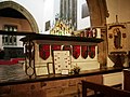
 Holy Trinity Church, Skipton, Pulpit - geograph.org.uk - 620658.jpg 640 × 480; 200 KB
-
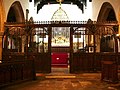 Holy Trinity Church, Skipton, Screen - geograph.org.uk - 620609.jpg 640 × 480; 196 KB
-
 Holy Trinity Church, Skipton, Side chapel - geograph.org.uk - 620663.jpg 640 × 480; 172 KB
-
 Holy Trinity Church, Skipton, Tomb - geograph.org.uk - 620664.jpg 640 × 480; 176 KB
-
 Holy Trinity Church, Skipton, Tower - geograph.org.uk - 620670.jpg 480 × 640; 175 KB
-

-
 House - Upper Town Street - geograph.org.uk - 616972.jpg 640 × 502; 48 KB
-
 Inquisitive sheep, near Woodend Farm - geograph.org.uk - 621310.jpg 640 × 394; 117 KB
-
 Inver Croft House - geograph.org.uk - 618656.jpg 640 × 480; 95 KB
-

-

-
 Leeds and Liverpool Canal junction, Skipton.jpg 640 × 480; 159 KB
-
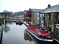 Leeds and Liverpool Canal, Skipton - geograph.org.uk - 622044.jpg 640 × 480; 217 KB
-

-

-
 Loch Eye from near Lochslin - geograph.org.uk - 616633.jpg 640 × 480; 80 KB
-
 Lochslin - geograph.org.uk - 616611.jpg 640 × 455; 96 KB
-
 Looking across Bangor at night - geograph.org.uk - 617405.jpg 444 × 640; 31 KB
-

-
 Looking out - geograph.org.uk - 617228.jpg 480 × 640; 78 KB
-

-
 Lord Cardigan - Town Street - geograph.org.uk - 616982.jpg 640 × 476; 28 KB
-
 Lovely brick house in Western Road - geograph.org.uk - 616734.jpg 640 × 480; 85 KB
-

-
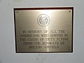 Memorial to Holton airfield - geograph.org.uk - 617254.jpg 640 × 480; 51 KB
-

-
 Memorials to U.S.A.A.F. Halesworth - geograph.org.uk - 617242.jpg 640 × 480; 68 KB
-
 MIdland Mainline Mk3 Buffet.JPG 2,560 × 1,920; 2.09 MB
-
 Morrisons supermarket, Berwick Hills - geograph.org.uk - 616336.jpg 640 × 446; 108 KB
-
 Muddy quagmire - geograph.org.uk - 616858.jpg 640 × 480; 103 KB
-
 Mudflats near Dingwall - geograph.org.uk - 616484.jpg 640 × 480; 42 KB
-
 Multi-storey car-park in Osborn Road - geograph.org.uk - 616690.jpg 640 × 480; 60 KB
-
 Mynwent Eglwys Boduan Churchyard - geograph.org.uk - 618265.jpg 640 × 428; 119 KB
-
 Mynwent Eglwys Boduan Churchyard - geograph.org.uk - 618271.jpg 640 × 428; 112 KB
-
-
 Near Lochslin - geograph.org.uk - 616650.jpg 640 × 457; 108 KB
-
 NHS dentists at Church Place - geograph.org.uk - 616531.jpg 640 × 480; 87 KB
-
 Nightclub near Bus Station - geograph.org.uk - 616705.jpg 640 × 480; 86 KB
-
 No lardies here - geograph.org.uk - 764823.jpg 640 × 480; 106 KB
-
 North Ormesby market - geograph.org.uk - 616335.jpg 640 × 480; 134 KB
-
 November Fields - geograph.org.uk - 616998.jpg 640 × 472; 73 KB
-
 Oak Wood - Henconner Lane - geograph.org.uk - 616992.jpg 640 × 506; 59 KB
-
 Omagh's four main churches - geograph.org.uk - 616326.jpg 640 × 232; 23 KB
-
 Oystercatchers, Deganwy - geograph.org.uk - 616455.jpg 640 × 480; 81 KB
-
 Peniel, Trefriw - geograph.org.uk - 618178.jpg 480 × 640; 57 KB
-
 Pensarn Park, Conwy - geograph.org.uk - 616525.jpg 640 × 474; 112 KB
-
 Porth Mynwent Eglwys Boduan Lych Gate - geograph.org.uk - 618262.jpg 640 × 428; 106 KB
-
 Public byway - geograph.org.uk - 616828.jpg 640 × 480; 88 KB
-
 Railway Line Towards Commondale - geograph.org.uk - 949672.jpg 640 × 480; 85 KB
-
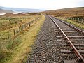
 Railway line towards Kildale - geograph.org.uk - 949680.jpg 640 × 480; 104 KB
-
 Raised beach at Ardersier - geograph.org.uk - 618648.jpg 640 × 480; 105 KB
-
 Rear of High Corn Mill - geograph.org.uk - 620595.jpg 480 × 640; 229 KB
-
-
 Red Lion Hotel, Fareham - geograph.org.uk - 616634.jpg 640 × 480; 55 KB
-
 River bank. Conwy - geograph.org.uk - 616524.jpg 640 × 480; 60 KB
-
 Rose and Crown, Coach Street, Skipton - geograph.org.uk - 622042.jpg 640 × 480; 188 KB
-
 The Rosemary Branch, Coldhams Lane - geograph.org.uk - 616383.jpg 640 × 481; 61 KB
-
 Royal Oak, Skipton.jpg 640 × 480; 149 KB
-
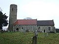
 Saxtead - Church of All Saints.jpg 640 × 480; 149 KB
-
 Shops - Upper Town Street - geograph.org.uk - 616973.jpg 640 × 419; 37 KB
-
 Signal Box, Deganwy Station - geograph.org.uk - 616450.jpg 640 × 480; 65 KB
-
 Site of old horse trough, Omagh - geograph.org.uk - 616324.jpg 640 × 346; 40 KB
-
 Site of Roman bath-house, Caerhun - geograph.org.uk - 617219.jpg 640 × 480; 93 KB
-
 Skipton Castle rear.jpg 640 × 480; 196 KB
-
 Skipton Castle, Gatehouse - geograph.org.uk - 620509.jpg 640 × 480; 202 KB
-

-

-
 Springs Branch or Lord Thanet's Canal. - geograph.org.uk - 620537.jpg 640 × 480; 191 KB
-
 Springs Branch or Lord Thanet's Canal. - geograph.org.uk - 620538.jpg 640 × 480; 194 KB
-
 St Benedict's Gyffyn - geograph.org.uk - 616807.jpg 640 × 480; 95 KB
-
 St Mary's Church, Caerhun - geograph.org.uk - 617218.jpg 640 × 480; 61 KB
-
 St Mary's Church, Trefriw - geograph.org.uk - 618177.jpg 640 × 480; 79 KB
-
 St Matthew's Church, Weeke - Chancel - geograph.org.uk - 616373.jpg 622 × 480; 50 KB
-
 St Matthew's Church, Weeke - geograph.org.uk - 616368.jpg 640 × 480; 48 KB
-
 St Matthew's Church, Weeke - west end - geograph.org.uk - 616375.jpg 640 × 480; 48 KB
-
 St Peters Church - geograph.org.uk - 617258.jpg 640 × 480; 69 KB
-
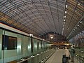 St.Pancras International. - geograph.org.uk - 646672.jpg 640 × 480; 103 KB
-
 Stocks and whipping post - geograph.org.uk - 617226.jpg 640 × 480; 70 KB
-

-
 The Brass Monkey - geograph.org.uk - 616643.jpg 640 × 480; 68 KB
-
 The Castle, 2 Mill Bridge, Skipton - geograph.org.uk - 620526.jpg 640 × 480; 217 KB
-
 The Craven Heifer Inn, Skipton - geograph.org.uk - 620485.jpg 640 × 480; 146 KB
-
 The Fairy Falls - geograph.org.uk - 618180.jpg 640 × 480; 83 KB
-
 The Kyle Line at Inver - geograph.org.uk - 618660.jpg 640 × 480; 128 KB
-
 The Old Vic - Whitecote Hill - geograph.org.uk - 616964.jpg 640 × 480; 28 KB
-
 The Original Factory Shop, Omagh - geograph.org.uk - 616422.jpg 640 × 480; 55 KB
-
 The Post Office, Trefriw - geograph.org.uk - 618179.jpg 640 × 480; 83 KB
-
 The Red Lion - geograph.org.uk - 616829.jpg 640 × 480; 69 KB
-
 The Royal Shepherd, Skipton - geograph.org.uk - 622031.jpg 640 × 480; 175 KB
-
 The Ulster Folk Museum (27) - geograph.org.uk - 616419.jpg 640 × 428; 52 KB
-
 The Ulster Folk Museum (28) - geograph.org.uk - 616426.jpg 640 × 428; 67 KB
-
 The Ulster Folk Museum (29) - geograph.org.uk - 616435.jpg 640 × 463; 70 KB
-
 The Ulster Folk Museum (30) - geograph.org.uk - 616451.jpg 640 × 428; 78 KB
-
 The Ulster Folk Museum (31) - geograph.org.uk - 616468.jpg 640 × 542; 117 KB
-
 The Ulster Folk Museum (32) - geograph.org.uk - 616475.jpg 640 × 428; 61 KB
-
 The Ulster Folk Museum (33) - geograph.org.uk - 616493.jpg 640 × 428; 86 KB
-
 The Ulster Folk Museum (34) - geograph.org.uk - 616500.jpg 640 × 428; 50 KB
-
 The Ulster Folk Museum (35) - geograph.org.uk - 616541.jpg 640 × 391; 82 KB
-
 The Ulster Folk Museum (36) - geograph.org.uk - 616556.jpg 640 × 428; 67 KB
-
 The Ulster Folk Museum (37) - geograph.org.uk - 616581.jpg 640 × 428; 89 KB
-
 The Ulster Folk Museum (38) - geograph.org.uk - 616619.jpg 640 × 428; 67 KB
-
 Three old friends at Bangor - geograph.org.uk - 617145.jpg 640 × 364; 65 KB
-
 Tight squeeze^ - geograph.org.uk - 616527.jpg 640 × 480; 108 KB
-
 Town surgery, Conwy - geograph.org.uk - 616535.jpg 480 × 640; 60 KB
-
 Trefriw War Memorial - geograph.org.uk - 617642.jpg 480 × 640; 89 KB
-


_-_geograph.org.uk_-_616710.jpg)


.jpg)


_-_geograph.org.uk_-_616419.jpg)
_-_geograph.org.uk_-_616426.jpg)
_-_geograph.org.uk_-_616435.jpg)
_-_geograph.org.uk_-_616451.jpg)
_-_geograph.org.uk_-_616468.jpg)
_-_geograph.org.uk_-_616475.jpg)
_-_geograph.org.uk_-_616493.jpg)
_-_geograph.org.uk_-_616500.jpg)
_-_geograph.org.uk_-_616541.jpg)
_-_geograph.org.uk_-_616556.jpg)
_-_geograph.org.uk_-_616581.jpg)
_-_geograph.org.uk_-_616619.jpg)


