Category:United Kingdom photographs taken on 2008-03-16
Countries of Europe: Austria · Belgium · Bosnia and Herzegovina · Croatia · Cyprus‡ · Czech Republic · Finland · France‡ · Germany · Greece · Hungary · Republic of Ireland · Italy · Latvia · Malta · Netherlands‡ · Norway · Poland · Portugal‡ · Russia‡ · San Marino · Slovakia · Spain‡ · Sweden · Switzerland · Turkey‡ · Ukraine · United Kingdom
‡: partly located in Europe
‡: partly located in Europe
| ← | 16 March 2008 | → | ||
| ← | March 2008 | → | ||

United Kingdom photographs taken on 16 March 2008.
Image files should be categorized here automatically using {{taken on}} template. Direct categorisation is also possible, if automatic is impossible.
Subcategories
This category has the following 3 subcategories, out of 3 total.
Media in category "United Kingdom photographs taken on 2008-03-16"
The following 200 files are in this category, out of 882 total.
(previous page) (next page)-
 "Two Trees" - geograph.org.uk - 726714.jpg 640 × 480; 69 KB
-

-
 350243 Watford Junction.JPG 1,646 × 1,439; 726 KB
-
 321415 DTSO Standard Class Interior.JPG 2,040 × 1,519; 939 KB
-
 350250 Watford Junction.JPG 1,698 × 1,408; 734 KB
-
 321415 A Watford Junction.JPG 1,397 × 829; 330 KB
-
 321415 TSO Standard Class Interior.JPG 2,029 × 1,535; 927 KB
-
 321426 Watford Junction.JPG 1,965 × 1,288; 795 KB
-
 350118 Watford Junction.JPG 1,604 × 1,115; 553 KB
-
 671 Leeds Road - geograph.org.uk - 726944.jpg 640 × 493; 99 KB
-
 A 458 into Shrewsbury - geograph.org.uk - 727212.jpg 640 × 480; 90 KB
-
 A 5 bridge over the River Severn - geograph.org.uk - 727278.jpg 640 × 480; 56 KB
-
 A lane out of Upper Longwood - geograph.org.uk - 727337.jpg 640 × 480; 72 KB
-
 A lane to Cound - geograph.org.uk - 727168.jpg 640 × 480; 74 KB
-
 A peaceful valley - geograph.org.uk - 727197.jpg 640 × 427; 248 KB
-
 A Volvo on the drive - geograph.org.uk - 727659.jpg 640 × 476; 108 KB
-
 A458 past 'The Peacock' - geograph.org.uk - 727208.jpg 640 × 480; 67 KB
-
 A458 to Much Wenlock - geograph.org.uk - 727170.jpg 640 × 480; 62 KB
-
 Aberdour Station - geograph.org.uk - 1007476.jpg 640 × 480; 96 KB
-
 Abhainn Beinn nan Eun - geograph.org.uk - 727536.jpg 640 × 480; 85 KB
-
 Abhainn Beinn nan Eun - geograph.org.uk - 727538.jpg 640 × 360; 63 KB
-
 Abhainn Beinn nan Eun - geograph.org.uk - 727603.jpg 640 × 360; 92 KB
-
 Abhainn Beinn nan Eun - geograph.org.uk - 727612.jpg 640 × 360; 47 KB
-
 Abhainn Beinn nan Eun - geograph.org.uk - 727633.jpg 640 × 360; 72 KB
-
 Achadh an Todhair - Upper Auchintore - geograph.org.uk - 914753.jpg 640 × 480; 78 KB
-
 Adel WWII Bunker - geograph.org.uk - 729617.jpg 640 × 424; 142 KB
-
 Aerial ropeway retaining block - geograph.org.uk - 727738.jpg 640 × 480; 346 KB
-
 All done by volunteers - geograph.org.uk - 726312.jpg 640 × 480; 92 KB
-
 Allt Bail' a' Mhuillinn - geograph.org.uk - 727298.jpg 640 × 480; 153 KB
-
 Allt Bail' a' Mhuillinn - geograph.org.uk - 727314.jpg 640 × 480; 150 KB
-
 Angler's tent and pony. - geograph.org.uk - 726522.jpg 640 × 480; 102 KB
-
 Approaching Belfast Central - geograph.org.uk - 726685.jpg 640 × 405; 82 KB
-
 As usual the sign says it all - geograph.org.uk - 727243.jpg 640 × 480; 66 KB
-
 Asda, St Marys Way - geograph.org.uk - 728771.jpg 640 × 375; 44 KB
-
 Au Naturale - Woodhall Retail Park - geograph.org.uk - 726974.jpg 640 × 411; 37 KB
-
 B and Q Store - Woodhall Retail Park - geograph.org.uk - 726945.jpg 640 × 430; 47 KB
-
 Bamburgh - geograph.org.uk - 728176.jpg 640 × 426; 101 KB
-
 Bank Street - geograph.org.uk - 728753.jpg 640 × 480; 82 KB
-
 Bank Street - geograph.org.uk - 728754.jpg 640 × 480; 68 KB
-
 Bank Street Shops - geograph.org.uk - 728758.jpg 640 × 480; 98 KB
-
 Barhaskine - geograph.org.uk - 727259.jpg 640 × 490; 93 KB
-
 Barhaskine - geograph.org.uk - 727266.jpg 640 × 480; 158 KB
-
 Barhaskine - geograph.org.uk - 727267.jpg 640 × 453; 133 KB
-
 Barhaskine - geograph.org.uk - 727270.jpg 480 × 640; 121 KB
-
 Barn, Fullaford - geograph.org.uk - 731333.jpg 640 × 426; 106 KB
-
 Basketball hoop at Bidbury Mead - geograph.org.uk - 726336.jpg 640 × 480; 43 KB
-
-
 Beach beside St Aidan's Dunes - geograph.org.uk - 728151.jpg 640 × 426; 52 KB
-
 Beck near North Cave - geograph.org.uk - 726689.jpg 480 × 640; 197 KB
-
 Bedford House, Belfast - geograph.org.uk - 727051.jpg 640 × 435; 79 KB
-
 Bedlington North Signal Box - geograph.org.uk - 727371.jpg 640 × 480; 97 KB
-
 Spiritualist Church - geograph.org.uk - 727358.jpg 640 × 375; 54 KB
-
 Ben Wyvis over Garbat Forest - geograph.org.uk - 727743.jpg 640 × 360; 28 KB
-
 Benfadyeon - West Slopes - geograph.org.uk - 726548.jpg 640 × 480; 87 KB
-
 Bessbrook Road towards Markethill - geograph.org.uk - 728046.jpg 640 × 480; 68 KB
-
 Bessbrook Road, Markethill - geograph.org.uk - 728080.jpg 640 × 480; 73 KB
-
 Bessbrook Road, Markethill - geograph.org.uk - 728118.jpg 640 × 480; 63 KB
-
 Bidbury Lane - geograph.org.uk - 726346.jpg 640 × 480; 133 KB
-
 Bidhouse ruin - geograph.org.uk - 726861.jpg 640 × 480; 142 KB
-
 Birchwoods beneath Druim na h-Earba - geograph.org.uk - 914738.jpg 640 × 480; 105 KB
-
 Birksland Street - geograph.org.uk - 726904.jpg 640 × 445; 33 KB
-
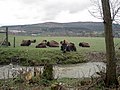
 Bison on the Rhug estate - 1 - geograph.org.uk - 727514.jpg 640 × 480; 74 KB
-
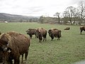
 Bison on the Rhug estate - 2 - geograph.org.uk - 727517.jpg 640 × 480; 94 KB
-
 Bison on the Rhug estate - 3 - geograph.org.uk - 727518.jpg 640 × 480; 111 KB
-
 Bison on the Rhug estate - 4 - geograph.org.uk - 728963.jpg 640 × 480; 123 KB
-
 Bison on the Rhug estate - 5 - geograph.org.uk - 728975.jpg 561 × 412; 123 KB
-
 Bison on the Rhug estate - 6 - geograph.org.uk - 728969.jpg 640 × 480; 83 KB
-
 Blarmacfoldach.jpg 640 × 480; 77 KB
-
 Blast Warnings on the approach to Vivian Quarry - geograph.org.uk - 1769520.jpg 1,024 × 768; 165 KB
-
 Blue Ball Pub at Worrall - geograph.org.uk - 726988.jpg 640 × 427; 64 KB
-
 Boundary Stone at Haigh Gutter - geograph.org.uk - 729712.jpg 427 × 640; 297 KB
-
 Branch Line of the Blyth and Tyne Line - geograph.org.uk - 727379.jpg 640 × 590; 118 KB
-
 Brickmakers Arms Pub, Luton Road - geograph.org.uk - 728702.jpg 640 × 480; 61 KB
-
 Bridge BRB DUH43 - Birksland Street - geograph.org.uk - 726901.jpg 640 × 572; 78 KB
-
 Bridge LBE3-4 - Birksland Street - geograph.org.uk - 726892.jpg 640 × 434; 48 KB
-
 Bridge LBE3-5 - Hammerton Street - geograph.org.uk - 726909.jpg 640 × 471; 55 KB
-

-
 Bridleway, Ramsden Clough - geograph.org.uk - 727607.jpg 481 × 640; 147 KB
-
 Brighton Pier (2339019958).jpg 2,108 × 1,433; 2.04 MB
-
 Brighton Pier 1 (2338178883).jpg 2,936 × 2,105; 3.96 MB
-
 Brighton Pier 2 (2338183393).jpg 3,008 × 1,944; 3.3 MB
-
 Brighton Pier a (3031422865).jpg 2,094 × 1,245; 1.12 MB
-
 Brighton Pier BW (2773698163).jpg 2,094 × 1,337; 1.46 MB
-
 Budle Bay - geograph.org.uk - 728203.jpg 640 × 426; 77 KB
-
 Budle Bay - geograph.org.uk - 728208.jpg 640 × 426; 70 KB
-
 Buildings on Howard Street, Glasgow - geograph.org.uk - 734479.jpg 640 × 480; 87 KB
-
 Burn, Upper Auchintore - geograph.org.uk - 914756.jpg 640 × 480; 108 KB
-

-
 Cairn Farm, Gatehouse - geograph.org.uk - 726609.jpg 640 × 480; 68 KB
-

-
 Car Wash and Sales Centre - geograph.org.uk - 728591.jpg 640 × 480; 76 KB
-
 Carpet Right - Woodhall Retail Park - geograph.org.uk - 726966.jpg 640 × 457; 44 KB
-
 Carse of Gowrie - geograph.org.uk - 727012.jpg 640 × 427; 46 KB
-
 Cashlie hydro electric power station - geograph.org.uk - 727345.jpg 640 × 480; 128 KB
-
 Cashlie power station - geograph.org.uk - 727348.jpg 480 × 640; 119 KB
-
 Chadwick House at dusk - geograph.org.uk - 1389365.jpg 640 × 480; 61 KB
-

-
 Chatham Hill (1) - geograph.org.uk - 727442.jpg 640 × 480; 76 KB
-
 Chatham Hill (2) - geograph.org.uk - 727928.jpg 640 × 480; 77 KB
-

-
 Chelsea Bridge - panoramio - José Claudio Marcott….jpg 768 × 1,024; 232 KB
-
 Chelsea Bridge - panoramio.jpg 1,024 × 768; 227 KB
-
 Chester Cross - geograph.org.uk - 826040.jpg 640 × 457; 379 KB
-
 Church Hall in Belmont Grove - geograph.org.uk - 726314.jpg 640 × 480; 50 KB
-
 Cleared forest, Blarmachfoldach - geograph.org.uk - 914731.jpg 640 × 480; 107 KB
-
 Clyde sunset - geograph.org.uk - 728484.jpg 640 × 480; 87 KB
-
 Conwy railway station in 2008.jpg 4,227 × 2,843; 8.19 MB
-
 Cottages by the green - geograph.org.uk - 726817.jpg 640 × 343; 54 KB
-
 Country school - geograph.org.uk - 726781.jpg 640 × 480; 65 KB
-
 County Hall 02 - geograph.org.uk - 727231.jpg 640 × 480; 93 KB
-
 Craigdallie from the south - geograph.org.uk - 726951.jpg 640 × 427; 80 KB
-
 Craignarget Hill - geograph.org.uk - 727110.jpg 640 × 480; 100 KB
-
 Craignarget Hill - geograph.org.uk - 727114.jpg 640 × 480; 102 KB
-
 Craignarget Hill - geograph.org.uk - 727118.jpg 640 × 480; 98 KB
-
 Cross Fell - geograph.org.uk - 854248.jpg 640 × 479; 43 KB
-
 Crossing the Tweed - geograph.org.uk - 728220.jpg 640 × 426; 47 KB
-
 Curious Sheep and a molehill - geograph.org.uk - 726516.jpg 640 × 480; 128 KB
-
 Cwm Rheidol Mine - geograph.org.uk - 728580.jpg 640 × 480; 265 KB
-
 Cycle crossing - geograph.org.uk - 727200.jpg 640 × 480; 74 KB
-
 Damp Birch Woodland - geograph.org.uk - 726511.jpg 640 × 480; 152 KB
-
 Dead tree - panoramio - SteveMi.jpg 2,560 × 1,920; 2.42 MB
-
 Deer fence and A835 - geograph.org.uk - 727717.jpg 640 × 360; 74 KB
-
 Deltic on the ELR - geograph.org.uk - 729156.jpg 640 × 350; 48 KB
-

-
 Dereham Maltings - geograph.org.uk - 1035659.jpg 640 × 480; 77 KB
-

-
 DFK - Wenlock Street, off Leeds Road - geograph.org.uk - 726926.jpg 640 × 512; 53 KB
-

-
 Disdow Lane, Gatehouse - geograph.org.uk - 726564.jpg 640 × 480; 110 KB
-

-
 Down Plantation - geograph.org.uk - 731319.jpg 640 × 333; 45 KB
-
 Drainage Channel 1 - geograph.org.uk - 728104.jpg 640 × 480; 81 KB
-
 Drewton Manor Farm.jpg 640 × 480; 203 KB
-
 Driveway and cottage - geograph.org.uk - 727344.jpg 640 × 480; 88 KB
-
 Druid's Plantation - geograph.org.uk - 727026.jpg 640 × 480; 134 KB
-
 Druim na h-Earba - geograph.org.uk - 914750.jpg 640 × 480; 80 KB
-
 Drystone Wall on Rape Hill (2) - geograph.org.uk - 729722.jpg 640 × 427; 318 KB
-
 Drystone Wall on Rape Hill - geograph.org.uk - 729720.jpg 640 × 390; 253 KB
-
 Dunrod Hill - geograph.org.uk - 728487.jpg 640 × 427; 74 KB
-
 East face on Aonach Mor - geograph.org.uk - 727621.jpg 640 × 480; 33 KB
-
 Easter Glen Quoich - geograph.org.uk - 939399.jpg 640 × 480; 80 KB
-
 Edderthorpe Street - Hammerton Street - geograph.org.uk - 726915.jpg 640 × 394; 46 KB
-
 Edinburgh Air control tower - geograph.org.uk - 728251.jpg 426 × 640; 54 KB
-
 Eilan Chlamail, Sound of Sleat - geograph.org.uk - 916469.jpg 640 × 480; 42 KB
-

-
 Elite Homes, Ramsden Clough - geograph.org.uk - 727651.jpg 640 × 480; 140 KB
-
 Emsdorf Street - geograph.org.uk - 727432.jpg 640 × 432; 69 KB
-
 Entrance to Hustyn Wood - geograph.org.uk - 727593.jpg 640 × 480; 104 KB
-
 Entrance to Shrewsbury Crematorium - geograph.org.uk - 727254.jpg 640 × 480; 95 KB
-

-
 Saxon Church at Escomb (geograph 727288).jpg 640 × 426; 128 KB
-
 Even a church has rubbish - geograph.org.uk - 728230.jpg 427 × 640; 257 KB
-
 Exit ramp - geograph.org.uk - 731507.jpg 640 × 426; 64 KB
-

-
 Faded sign, Belfast - geograph.org.uk - 726838.jpg 572 × 452; 92 KB
-
 Farmland, Blarmachfoldach - geograph.org.uk - 738040.jpg 640 × 480; 75 KB
-
 A promising path - geograph.org.uk - 726806.jpg 480 × 640; 149 KB
-
 Fearby and Healey village hall - geograph.org.uk - 726790.jpg 640 × 480; 101 KB
-
 Fence, Calfhope Hill - geograph.org.uk - 726822.jpg 640 × 480; 103 KB
-
 Fencepost on rough moorland - geograph.org.uk - 727701.jpg 640 × 480; 121 KB
-
 Flare Bridge - panoramio.jpg 1,685 × 2,528; 3.5 MB
-
 Footbridge over ford at Hustyn Mill - geograph.org.uk - 727597.jpg 640 × 480; 123 KB
-

-

-
 Forest Edge - geograph.org.uk - 783608.jpg 640 × 480; 74 KB
-
 Former chapel in Fearby - geograph.org.uk - 726812.jpg 480 × 640; 81 KB
-
 Former Church House, Belfast (6) - geograph.org.uk - 727128.jpg 625 × 515; 76 KB
-
 Former Church House, Belfast (7) - geograph.org.uk - 727141.jpg 521 × 394; 64 KB
-

-
 Former Ulster Bank, Belfast - geograph.org.uk - 726813.jpg 477 × 511; 46 KB
-
 Forsyth House, Belfast - geograph.org.uk - 726785.jpg 640 × 370; 98 KB
-
 Forth bridges - geograph.org.uk - 728300.jpg 640 × 426; 30 KB
-
 Gaitgil Lane, Back Lodge - geograph.org.uk - 726624.jpg 640 × 480; 125 KB
-
 Gatliff Road - panoramio.jpg 768 × 1,024; 232 KB
-
 General Post Office - geograph.org.uk - 728811.jpg 640 × 405; 62 KB
-
 Glasgow Central Mosque - geograph.org.uk - 734442.jpg 640 × 480; 64 KB
-
 Glenanne Road at Mountnorris - geograph.org.uk - 728029.jpg 640 × 480; 98 KB
-
 Glengour - geograph.org.uk - 914746.jpg 640 × 480; 83 KB
-
 Gleouraich - geograph.org.uk - 932771.jpg 640 × 395; 71 KB
-
 Gorse above the Wyche Quarry. - geograph.org.uk - 728738.jpg 640 × 427; 285 KB
-
 Gorse in flower - geograph.org.uk - 743447.jpg 640 × 427; 322 KB
-

-
 Grazing in progress - geograph.org.uk - 726712.jpg 640 × 480; 71 KB
-
 Great Vintcombe - geograph.org.uk - 731293.jpg 640 × 359; 57 KB
-
 Green Fields - geograph.org.uk - 728020.jpg 640 × 383; 58 KB
-
 Grobdale - geograph.org.uk - 726538.jpg 640 × 480; 61 KB
-
 Grobdale of Balmaghie - geograph.org.uk - 726530.jpg 640 × 480; 57 KB
-
 Hammerton Street Filling Station - geograph.org.uk - 726920.jpg 640 × 489; 51 KB
-
 Hampden Park - geograph.org.uk - 728348.jpg 640 × 482; 68 KB
-
 Healey, North Yorkshire.jpg 640 × 325; 41 KB
-
 Hedon Haven Mudflats - geograph.org.uk - 727421.jpg 640 × 480; 78 KB
-
 Heywood Hill (2345074745).jpg 1,855 × 1,378; 1.25 MB
-
 High Court, Glasgow - geograph.org.uk - 734407.jpg 640 × 480; 67 KB
-
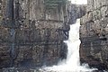 High force, Teesdale - geograph.org.uk - 727281.jpg 640 × 426; 88 KB
-
 High Gillespie chambered cairn - geograph.org.uk - 727131.jpg 640 × 480; 149 KB
-
 High Gillespie chambered cairn - geograph.org.uk - 727137.jpg 640 × 480; 124 KB
-
 High Lee Slack - geograph.org.uk - 727551.jpg 640 × 477; 83 KB
-
 Hillsborough College - geograph.org.uk - 726973.jpg 640 × 427; 45 KB
-
 HMS Albion at Plymouth. - panoramio.jpg 2,816 × 2,120; 1.43 MB
-
 Hollymount House - geograph.org.uk - 728770.jpg 640 × 480; 85 KB

_slippery_path_at_St_Thomas_A%27Becket_-_geograph.org.uk_-_726334.jpg)


.jpg)
.jpg)
.jpg)
.jpg)
.jpg)


_and_Haymarket_station_-_geograph.org.uk_-_1005183.jpg)


_-_geograph.org.uk_-_727442.jpg)
_-_geograph.org.uk_-_727928.jpg)


_-_geograph.org.uk_-_729722.jpg)


.jpg)


_-_geograph.org.uk_-_727128.jpg)
_-_geograph.org.uk_-_727141.jpg)


.jpg)


