Category:Unter Gabelhorn
| Object location | | View all coordinates using: OpenStreetMap |
|---|
mountain in Switzerland  | |||||
| Upload media | |||||
| Instance of | |||||
|---|---|---|---|---|---|
| Location | Valais, Switzerland | ||||
| Mountain range | |||||
| Topographic prominence |
| ||||
| Elevation above sea level |
| ||||
| Parent peak | |||||
 | |||||
Français : L'Unter Gabelhorn est un sommet de 3392 mètres du canton du Valais, en Suisse
English: The Unter Gabelhorn is a montain in the Pennine Alps in Switzerland
Media in category "Unter Gabelhorn"
The following 33 files are in this category, out of 33 total.
-
 13-Schwarzsee-NW.jpg 4,240 × 2,832; 7.34 MB
-
 2008-07-23 Schwarzsee (Zermatt) - 9.jpg 2,700 × 1,800; 877 KB
-
 ETH-BIB-Unter Gabelhorn, Matterhorn, General Milch-Inlandflüge-LBS MH05-61-04.tif 3,508 × 2,343; 23.57 MB
-
 ETH-BIB-Unter Gabelhorn, Matterhorn, General Milch-Inlandflüge-LBS MH05-61-05.tif 3,508 × 2,342; 23.56 MB
-
 ETH-BIB-Unter Gabelhorn, Matterhorn, General Milch-Inlandflüge-LBS MH05-61-06.tif 3,508 × 2,340; 23.54 MB
-
 ETH-BIB-Unter Gabelhorn, Matterhorn, General Milch-Inlandflüge-LBS MH05-61-07.tif 3,508 × 2,339; 23.53 MB
-
 ETH-BIB-Unter Gabelhorn, Matterhorn, General Milch-Inlandflüge-LBS MH05-61-08.tif 3,508 × 2,342; 23.56 MB
-
 ETH-BIB-Unter Gabelhorn, Matterhorn, General Milch-Inlandflüge-LBS MH05-61-09.tif 3,508 × 2,345; 23.59 MB
-
 ETH-BIB-Unter Gabelhorn, Matterhorn, General Milch-Inlandflüge-LBS MH05-61-10.tif 3,508 × 2,344; 23.58 MB
-
 ETH-BIB-Unter Gabelhorn, Matterhorn, General Milch-Inlandflüge-LBS MH05-61-15.tif 3,508 × 2,343; 23.57 MB
-
 ETH-BIB-Unter Gabelhorn, Matterhorn, General Milch-Inlandflüge-LBS MH05-61-16.tif 3,508 × 2,345; 23.59 MB
-
 ETH-BIB-Unter Gabelhorn, Matterhorn, General Milch-Inlandflüge-LBS MH05-61-19.tif 3,508 × 2,344; 23.58 MB
-
 ETH-BIB-Unter Gabelhorn, Matterhorn, General Milch-Inlandflüge-LBS MH05-61-22.tif 3,508 × 2,359; 23.75 MB
-
 ETH-BIB-Unter Gabelhorn, Matterhorn, General Milch-Inlandflüge-LBS MH05-61-25.tif 3,508 × 2,350; 23.68 MB
-
 ETH-BIB-Unter Gabelhorn, Matterhorn, General Milch-Inlandflüge-LBS MH05-61-30.tif 3,508 × 2,285; 23 MB
-
 ETH-BIB-Unter Gabelhorn, Matterhorn, General Milch-Inlandflüge-LBS MH05-61-33.tif 3,508 × 2,317; 23.34 MB
-
 ETH-BIB-Unter Gabelhorn, Matterhorn, General Milch-Inlandflüge-LBS MH05-61-35.tif 3,508 × 2,275; 22.92 MB
-
 ETH-BIB-Unter Gabelhorn, Mettelhorn, Dom, Täschhorn-Inlandflüge-LBS MH05-17-54.tif 3,508 × 2,331; 23.49 MB
-
 Glaciers in Zermatt 3.jpg 4,262 × 2,098; 2.75 MB
-
 Gämsen vor den Dents Blanches und Obergabelhorn.jpg 5,760 × 3,840; 8.26 MB
-
 Ober Gabelhorn & Wellenkuppe, 2010 July 2.JPG 4,441 × 2,836; 2.36 MB
-
 Ober Gabelhorn & Wellenkuppe, 2010 July, bw.JPG 4,441 × 2,836; 2.38 MB
-
 Ober Gabelhorn & Wellenkuppe, 2010 July.JPG 5,184 × 3,456; 3.19 MB
-
 Ober Gabelhorn and Wellenkuppe.JPG 4,000 × 3,000; 4.36 MB
-
 Ober Gabelhorn, 2010 July, bw.JPG 2,447 × 1,717; 863 KB
-
 Ober Gabelhorn, 2010 July.JPG 2,447 × 1,717; 865 KB
-
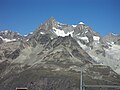
 Obergabelhorn - Unter Gabelhorn.jpg 1,313 × 550; 274 KB
-
 Obergabelhorn Gabelhorngletscher.jpg 4,000 × 3,000; 4.4 MB
-
 Stellisee Dent Blanche Obergabelhorn Wellenkuppe.jpg 4,000 × 3,000; 4.71 MB
-
 Unter Gabelhorn 2019.jpg 2,121 × 1,351; 1.15 MB
-
 Unter Gabelhorn from zermatt summer 2020.jpg 719 × 958; 201 KB
-
 Unter Gabelhorn on summer 2020.jpg 908 × 1,210; 371 KB
-
 Unter Gabelhorn.jpg 2,787 × 1,137; 1.26 MB

_-_9.jpg)


