Category:Unterdürnbach Wirtschaftshof
| Object location | | View all coordinates using: OpenStreetMap |
|---|
 | |||||
| Upload media | |||||
| Instance of | |||||
|---|---|---|---|---|---|
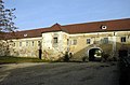
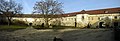
| Location | Maissau, Hollabrunn District, Lower Austria, Austria | ||||
| Street address |
| ||||
| Heritage designation | |||||
 | |||||
Media in category "Unterdürnbach Wirtschaftshof"
The following 8 files are in this category, out of 8 total.
-
 Unterdürnbach Wirtschaftshof 1.jpg 3,008 × 2,000; 4.67 MB
-
 Unterdürnbach Wirtschaftshof 2.jpg 3,008 × 2,000; 4.38 MB
-
 Unterdürnbach Wirtschaftshof 3.jpg 2,917 × 1,928; 3.86 MB
-
 Unterdürnbach Wirtschaftshof 4.jpg 2,860 × 1,907; 4.24 MB
-
 Unterdürnbach Wirtschaftshof 5.jpg 5,656 × 1,943; 9.45 MB
-
 Unterdürnbach Wirtschaftshof 6.jpg 3,008 × 2,000; 4.23 MB
-
 Unterdürnbach Wirtschaftshof 7.jpg 1,989 × 2,964; 4.12 MB
-
 Unterdürnbach Wirtschaftshof 8.jpg 3,008 × 2,000; 4.75 MB


