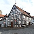
Category:Untere Fulder Gasse 45/47 (Alsfeld)
| Object location | | View all coordinates using: OpenStreetMap |
|---|
This is the category of the Hessian Kulturdenkmal (cultural monument) with the ID 13242 (Wikidata)
|
protected building in Alsfeld, Hesse, Germany  | |||||
| Upload media | |||||
| Instance of | |||||
|---|---|---|---|---|---|
| Location | Alsfeld, Vogelsbergkreis, Giessen Government Region, Hesse, Germany | ||||
| Located on street |
| ||||
 | |||||
Media in category "Untere Fulder Gasse 45/47 (Alsfeld)"
The following 9 files are in this category, out of 9 total.
-
 Alsfeld Untere Fulder Gasse 41 13241.png 2,238 × 2,414; 7.29 MB
-
 Alsfeld Untere Fulder Gasse 45-47.jpg 4,000 × 6,000; 17.98 MB
-
 Alsfeld, Untere Fulder Gasse 45 und 47-20160504-006.jpg 3,983 × 5,967; 12.36 MB
-
 Alsfeld, Untere Fulder Gasse 45 und 47-20160504-007.jpg 5,917 × 3,950; 12.2 MB
-
 Alsfeld, Untere Fulder Gasse 45 und 47-20160504-008.jpg 4,016 × 6,016; 13.02 MB
-
 Alsfeld, Untere Fulder Gasse 45 und 47-20160504-009.jpg 5,917 × 3,950; 11.9 MB
-
 Alsfeld, Untere Fulder Gasse 45 und 47-20160504-010.jpg 3,882 × 5,815; 10.51 MB
-
 Alsfeld, Untere Fulder Gasse 45-47.jpg 4,774 × 4,851; 13.51 MB
-
 Alsfeld, Untere Fulder Gasse 49 und 51, 45 und 47, 41 und 43-20160504-006.jpg 3,919 × 5,871; 9.64 MB


