Category:Uplyme
English: Uplyme is a village which lies in East Devon on the Devon-Dorset border and the River Lym, adjacent to the Dorset coastal town of Lyme Regis. It has a population of approximately 1700.
village in Devon, England, United Kingdom  | |||||
| Upload media | |||||
| Instance of | |||||
|---|---|---|---|---|---|
| Location | East Devon, Devon, South West England, England | ||||
| Population |
| ||||
| Area |
| ||||
| Said to be the same as | Uplyme | ||||
 | |||||
Subcategories
This category has the following 7 subcategories, out of 7 total.
C
- Cannington Viaduct, Devon (16 F)
H
- Holcombe, East Devon (1 F)
- Honeysuckle Cottage, Uplyme (3 F)
T
- Talbot Arms, Uplyme (5 F)
W
- Uplyme War Memorial (1 F)
- Ware, Devon (6 F)
Media in category "Uplyme"
The following 200 files are in this category, out of 294 total.
(previous page) (next page)-
 "Chimney rock" - geograph.org.uk - 278695.jpg 480 × 640; 86 KB
-
 A fallen tree blocking the bridleway - geograph.org.uk - 5914790.jpg 5,343 × 3,005; 5.19 MB
-
 A3052 heading west - geograph.org.uk - 6219258.jpg 1,024 × 684; 275 KB
-
 A3052 road near Ware Cross - geograph.org.uk - 5249857.jpg 640 × 426; 87 KB
-
 A35 Raymonds Hill - geograph.org.uk - 6211029.jpg 640 × 480; 44 KB
-
 A35, Greenway Head - geograph.org.uk - 3038930.jpg 640 × 430; 59 KB
-
 A35, Penn Hill - geograph.org.uk - 3038928.jpg 640 × 430; 40 KB
-
 A35, Raymond's Hill - geograph.org.uk - 6219904.jpg 1,024 × 684; 283 KB
-
-
 Allerford (1).jpg 3,898 × 2,307; 3.15 MB
-
 Alpacas, Rocombe Bottom - geograph.org.uk - 4750430.jpg 1,920 × 1,440; 871 KB
-
 B3165 in Uplyme - geograph.org.uk - 4597087.jpg 1,920 × 1,386; 695 KB
-
 B3165 Lyme Road - geograph.org.uk - 6211030.jpg 640 × 480; 90 KB
-
 B3165 Lyme Road, Yawl - geograph.org.uk - 6211031.jpg 640 × 480; 47 KB
-
 B3165 Lyme Road. Uplyme village sign - geograph.org.uk - 6211032.jpg 640 × 480; 74 KB
-
 B3165 on Yawl Hill - geograph.org.uk - 4597153.jpg 1,920 × 1,440; 961 KB
-
 B3165 on Yawl Hill - geograph.org.uk - 5010308.jpg 1,600 × 1,279; 803 KB
-
 B3165 Uplyme, Dorset border sign - geograph.org.uk - 6211072.jpg 640 × 480; 61 KB
-
 Baled field, Whitty Hill - geograph.org.uk - 4750475.jpg 1,920 × 1,181; 576 KB
-
 Bare trees beside Trinity Hill Road - geograph.org.uk - 6356553.jpg 1,197 × 1,600; 993 KB
-
 Barn Immediately North East Of Court Hall Farm House.jpg 244 × 228; 19 KB
-

-
 Bluebells up coach road - geograph.org.uk - 1279573.jpg 427 × 640; 106 KB
-
 Boating Centre by A35 near Raymond's Hill - geograph.org.uk - 5010309.jpg 1,600 × 1,200; 689 KB
-

-
 Bridge over the River Lym, Uplyme - geograph.org.uk - 3556101.jpg 3,456 × 2,592; 3.36 MB
-
 Bridleway along a field edge - geograph.org.uk - 5582811.jpg 1,024 × 683; 265 KB
-
 Bridleway near Valley View Farm - geograph.org.uk - 4750373.jpg 1,920 × 2,560; 1.35 MB
-
 Bridleway signpost near Old Mill - geograph.org.uk - 4751369.jpg 1,920 × 2,367; 1.24 MB
-
 Bridleway to Rocombe Bottom - geograph.org.uk - 4750410.jpg 1,920 × 2,237; 1.54 MB
-
 Bridleway, Rocombe Bottom - geograph.org.uk - 4750415.jpg 1,920 × 2,560; 1.21 MB
-
 Bridleway, Uplyme - geograph.org.uk - 4598256.jpg 1,920 × 1,357; 830 KB
-
 Campground on St Mary's Lane - geograph.org.uk - 4598113.jpg 2,519 × 1,845; 1,022 KB
-
 Cannington Lane - geograph.org.uk - 5555733.jpg 640 × 427; 115 KB
-
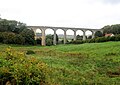 Cannington Viaduct - geograph.org.uk - 5555725.jpg 640 × 453; 77 KB
-
 Carswell - Rocombe Bottom - geograph.org.uk - 4750357.jpg 1,920 × 1,440; 901 KB
-
 Carswell - Rocombe Bottom - geograph.org.uk - 4750386.jpg 1,920 × 1,350; 817 KB
-
 Carswell Bottom - geograph.org.uk - 177251.jpg 640 × 480; 174 KB
-
 Carswell Bottom - geograph.org.uk - 4598730.jpg 1,920 × 1,457; 929 KB
-
 Carswell Bottom - geograph.org.uk - 4750355.jpg 2,695 × 1,635; 1.08 MB
-
 Carswell Bottom - geograph.org.uk - 4750380.jpg 1,920 × 1,265; 908 KB
-
 Cement works steelwork, westward view - geograph.org.uk - 1988890.jpg 1,547 × 2,000; 1.28 MB
-
 Chalk Clff, Undercliff - geograph.org.uk - 1184327.jpg 640 × 480; 104 KB
-
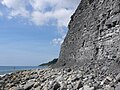 Cliffs at Seven Rock Point - geograph.org.uk - 5516213.jpg 640 × 480; 89 KB
-
 Cliffs east of Seven Rock Point - geograph.org.uk - 5005487.jpg 1,600 × 1,200; 740 KB
-
 Coast at Pinhay Warren - geograph.org.uk - 2906397.jpg 768 × 1,024; 377 KB
-
 Coast path on Ware Cliffs - geograph.org.uk - 3158916.jpg 640 × 480; 134 KB
-
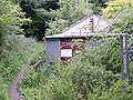
 Come In Number 4 Your Time Is Up - geograph.org.uk - 1317476.jpg 480 × 640; 100 KB
-
 Cottage, Uplyme - geograph.org.uk - 4751473.jpg 1,920 × 2,058; 691 KB
-
 Cottage, Uplyme - geograph.org.uk - 4751522.jpg 1,920 × 2,453; 920 KB
-
 Cottages, Harcombe - geograph.org.uk - 4750499.jpg 1,920 × 1,239; 527 KB
-
 Cottages, Uplyme - geograph.org.uk - 4751511.jpg 1,920 × 1,440; 602 KB
-
 Cottages, Venlake, Uplyme - geograph.org.uk - 3555586.jpg 3,327 × 2,140; 1.52 MB
-
 Court Hall Farm, Uplyme - geograph.org.uk - 4751593.jpg 1,920 × 1,128; 572 KB
-
 Crossroads in Uplyme - geograph.org.uk - 1072421.jpg 640 × 480; 66 KB
-
 Crossroads near Ware - geograph.org.uk - 1072385.jpg 640 × 362; 54 KB
-
 Culvert - geograph.org.uk - 110075.jpg 640 × 480; 61 KB
-

-
 Devon Hotel (1).jpg 4,032 × 2,337; 1.69 MB
-
 Devonshire Head west of Lyme Regis - geograph.org.uk - 5005479.jpg 1,600 × 1,200; 659 KB
-

-
 Dorset County Boundary, A35 - geograph.org.uk - 2428167.jpg 640 × 476; 68 KB
-
 East Devon , The A35 in Fog - geograph.org.uk - 2279076.jpg 2,048 × 1,536; 353 KB
-
 East Devon Way - geograph.org.uk - 1065247.jpg 640 × 480; 91 KB
-
 East Devon Way - geograph.org.uk - 1065296.jpg 640 × 480; 82 KB
-
 East Devon Way - geograph.org.uk - 1065413.jpg 480 × 640; 99 KB
-
 East Devon Way - geograph.org.uk - 1066536.jpg 640 × 480; 146 KB
-
 East Devon Way by the B3165 - geograph.org.uk - 4597098.jpg 1,920 × 1,440; 1,019 KB
-
 East Devon Way in Uplyme - geograph.org.uk - 4597104.jpg 1,920 × 2,560; 1.66 MB
-
 Edward VII Post Box - geograph.org.uk - 5344161.jpg 427 × 640; 93 KB
-
 Elton.jpg 4,032 × 3,024; 2.48 MB
-
 Entering Devon, A3052 - geograph.org.uk - 5249849.jpg 640 × 426; 83 KB
-
 Entrance Ladder's Coppice - geograph.org.uk - 5275511.jpg 3,776 × 2,520; 4.14 MB
-
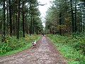
 Entrance to forest - geograph.org.uk - 1804335.jpg 1,600 × 1,200; 979 KB
-
 Entrance to Hill Farm - geograph.org.uk - 5555745.jpg 640 × 427; 76 KB
-
 Entrance to Rhode Hill Estate - geograph.org.uk - 412577.jpg 640 × 480; 62 KB
-
 Entrance to Shapwick Quarry - geograph.org.uk - 5555712.jpg 640 × 438; 58 KB
-

-

-
 Entrance to Underhill Farm - geograph.org.uk - 5544671.jpg 1,024 × 768; 338 KB
-
 Entrance to White Ley - geograph.org.uk - 5344218.jpg 640 × 373; 112 KB
-
 Ethelston's Close, Uplyme - geograph.org.uk - 4598218.jpg 1,920 × 1,089; 585 KB
-
 Fallen Tree across the Bridleway - geograph.org.uk - 5582868.jpg 1,024 × 683; 404 KB
-
 Farm Building Immediately South East Of Court Hall Farm House 2.jpg 2,272 × 1,357; 754 KB
-
 Farm Building Immediately South East Of Court Hall Farm House.jpg 4,032 × 3,024; 6.51 MB
-
 Field above Carswell Bottom - geograph.org.uk - 4750395.jpg 2,699 × 1,794; 1.54 MB
-
 Field by Gore Lane - geograph.org.uk - 1072395.jpg 640 × 480; 67 KB
-
 Fields near Rhode Hill - geograph.org.uk - 412591.jpg 640 × 480; 47 KB
-
 Footbridge on county boundary - geograph.org.uk - 4750637.jpg 2,112 × 2,816; 1.61 MB
-
 Former shop, Uplyme - geograph.org.uk - 5009915.jpg 1,600 × 1,200; 699 KB
-
 From Devon to Dorset near Lyme Regis - geograph.org.uk - 5808853.jpg 656 × 800; 124 KB
-
 Gateway into Woolly Wood - geograph.org.uk - 5556071.jpg 640 × 427; 111 KB
-
 Goldencap from undercliff 06.05.JPG 2,560 × 1,920; 2.43 MB
-
 Gore Lane at Hill Farm - geograph.org.uk - 4596092.jpg 2,778 × 1,690; 944 KB
-
 Gore Lane bridge - geograph.org.uk - 1065195.jpg 640 × 480; 114 KB
-
 Gore Lane, Uplyme - geograph.org.uk - 4110535.jpg 6,016 × 4,000; 4.96 MB
-
 Gore Lane, Uplyme - geograph.org.uk - 4110582.jpg 6,016 × 4,000; 4.2 MB
-
 Grass field below The Crow's Nest - geograph.org.uk - 5707185.jpg 1,024 × 768; 153 KB
-
 Grazing above Carswell Bottom - geograph.org.uk - 4750402.jpg 1,920 × 1,440; 784 KB
-
 Grazing near Rhode Hill - geograph.org.uk - 412573.jpg 640 × 480; 40 KB
-
 Hairpin bend at St Mary's Woods in Yawl - geograph.org.uk - 1804321.jpg 1,600 × 1,200; 922 KB
-
 Harcombe Bottom - geograph.org.uk - 4750482.jpg 1,920 × 1,151; 594 KB
-
 Harcombe Cottage - geograph.org.uk - 4750533.jpg 1,525 × 1,905; 571 KB
-
 Harcombe Farm - geograph.org.uk - 4750543.jpg 1,920 × 1,543; 586 KB
-
 Harcombe Road - geograph.org.uk - 5346637.jpg 640 × 427; 114 KB
-
 Harcombe, postbox No. DT7 47 - geograph.org.uk - 982521.jpg 640 × 480; 123 KB
-
 Hart Grove Farm - geograph.org.uk - 171625.jpg 640 × 481; 93 KB
-
 Holcombe from Woodhouse Lane - geograph.org.uk - 455849.jpg 640 × 480; 95 KB
-
 Hook Farm camping site, Uplyme - geograph.org.uk - 3555620.jpg 3,401 × 2,068; 1.04 MB
-
 Hook Farm campsite - geograph.org.uk - 4103029.jpg 5,480 × 3,500; 3.56 MB
-
 Hook Farm campsite, Uplyme - geograph.org.uk - 4103028.jpg 5,079 × 3,390; 2.64 MB
-
 Hook Farm Campsite, Uplyme - geograph.org.uk - 918641.jpg 640 × 425; 89 KB
-
 Horseshoe Cottage Sunnybanks.jpg 4,032 × 3,024; 5.07 MB
-
 House in Uplyme - geograph.org.uk - 5555862.jpg 640 × 427; 68 KB
-
 House in Yawl - geograph.org.uk - 4489469.jpg 640 × 428; 99 KB
-
 House on Trinity Hill Rd - geograph.org.uk - 5274894.jpg 640 × 427; 86 KB
-
 Houses along a Narrow Hilltop Road - geograph.org.uk - 5582828.jpg 1,024 × 683; 286 KB
-
 Houses in Uplyme - geograph.org.uk - 4491423.jpg 640 × 428; 82 KB
-
 Hunters Lodge Inn - geograph.org.uk - 4473263.jpg 640 × 480; 62 KB
-
 In the Woodland on Trinity Hill - geograph.org.uk - 5582894.jpg 683 × 1,024; 454 KB
-
 Into Uplyme, Devon - geograph.org.uk - 5808888.jpg 773 × 800; 159 KB
-
 Junction by the church, Uplyme - geograph.org.uk - 4598208.jpg 1,920 × 1,075; 479 KB
-
 Junction of Harcombe Rd and Charmouth Rd - geograph.org.uk - 4473266.jpg 640 × 428; 109 KB
-
 Keep Out - geograph.org.uk - 1065326.jpg 640 × 480; 121 KB
-
 King George's Field, Uplyme - geograph.org.uk - 3556095.jpg 3,298 × 1,923; 1.4 MB
-
 Knoll Hill - geograph.org.uk - 2731632.jpg 4,176 × 2,784; 4.83 MB
-
 Lambs near Rhodes Hill - geograph.org.uk - 1317469.jpg 640 × 427; 95 KB
-
 Lane at entrance to Rhode Hill House - geograph.org.uk - 412587.jpg 640 × 480; 40 KB
-
 Lane End Farmhouse (1).jpg 4,032 × 3,024; 4.17 MB
-
 Lane into Uplyme - geograph.org.uk - 1317399.jpg 640 × 480; 111 KB
-
 Lane to Harcombe Bottom - geograph.org.uk - 5346629.jpg 640 × 427; 137 KB
-
 Layby on A3052 - geograph.org.uk - 6219249.jpg 1,024 × 684; 300 KB
-
 Lias Cliff, West of Lyme Regis - geograph.org.uk - 771487.jpg 640 × 480; 115 KB
-
 Limestones, Marls and Shales - geograph.org.uk - 4438932.jpg 640 × 430; 86 KB
-
 Long Hill - geograph.org.uk - 5555490.jpg 640 × 427; 66 KB
-
 Lyme Road (B3165) between Uplyme and Yawl - geograph.org.uk - 5010304.jpg 1,600 × 1,200; 750 KB
-
 Maize, Whitty Down - geograph.org.uk - 4750470.jpg 1,920 × 1,397; 618 KB
-
 Maize, Whitty Hill - geograph.org.uk - 4750480.jpg 1,920 × 1,388; 679 KB
-
 Meadow, Harcombe - geograph.org.uk - 4750602.jpg 1,920 × 1,363; 798 KB
-
 Memorials, Uplyme churchyard - geograph.org.uk - 4598240.jpg 1,920 × 1,720; 1.33 MB
-

-
 Mill Lane - geograph.org.uk - 4751386.jpg 1,920 × 2,560; 1.62 MB
-
 Mill Lane - geograph.org.uk - 5582748.jpg 1,024 × 683; 306 KB
-
 Mona House.jpg 3,977 × 2,223; 2.58 MB
-
 Monmouth Beach, Lyme - geograph.org.uk - 1988808.jpg 2,000 × 1,495; 1.14 MB
-
 Mrs Ethelston's C of E Primary School, Uplyme - geograph.org.uk - 3556078.jpg 3,088 × 2,176; 1.55 MB
-
 Mrs Ethelston's CofE Primary Academy.jpg 4,032 × 2,184; 3.23 MB
-
 Murco filling station, Uplyme - geograph.org.uk - 5010303.jpg 1,600 × 1,200; 629 KB
-
 Oats by Gore Lane - geograph.org.uk - 4596127.jpg 1,920 × 1,372; 951 KB
-
 Old Mill (1).jpg 4,032 × 3,024; 8.34 MB
-
 Old Mill, Lyme Regis - geograph.org.uk - 5273456.jpg 3,776 × 2,520; 4.21 MB
-
 Old Mill, Uplyme - geograph.org.uk - 4598874.jpg 1,920 × 1,650; 797 KB
-
 Old Mill, Uplyme - geograph.org.uk - 4598884.jpg 1,920 × 1,289; 1,023 KB
-
 Old Mill, Uplyme - geograph.org.uk - 4598902.jpg 1,920 × 1,440; 824 KB
-

-
 On Ware Cliffs, a junction of footpaths - geograph.org.uk - 3077143.jpg 1,000 × 750; 796 KB
-
 Orchard Woods - geograph.org.uk - 5555480.jpg 640 × 427; 125 KB
-
 Ordnance Survey Cut Mark with Bolt - geograph.org.uk - 3937330.jpg 4,000 × 3,000; 4.44 MB
-
 Ordnance Survey Flush Bracket 2146 - geograph.org.uk - 3937304.jpg 4,000 × 3,000; 2.42 MB
-
 Path Through Sleech Wood - geograph.org.uk - 1317440.jpg 640 × 480; 170 KB
-
 Path to Harcombe Stream - geograph.org.uk - 4750618.jpg 1,920 × 2,146; 1.3 MB
-
 Path to Rhode Hill - geograph.org.uk - 1317423.jpg 640 × 480; 101 KB
-
 Path to Ware Cliffs - geograph.org.uk - 5535705.jpg 640 × 480; 140 KB
-
 Path, Whitty Hill - geograph.org.uk - 4750484.jpg 1,920 × 2,560; 1.36 MB
-
 Path, Whitty Hill - geograph.org.uk - 4750494.jpg 1,920 × 2,560; 1.68 MB
-
 Path, Whitty Hill - geograph.org.uk - 4750495.jpg 1,920 × 2,560; 1.81 MB
-
 Pine Forest at Hoyton Hill - geograph.org.uk - 1067299.jpg 640 × 480; 129 KB
-
 Pinhay , Cannington Viaduct - geograph.org.uk - 5851205.jpg 1,600 × 1,067; 416 KB
-
 Pinhay Bay - geograph.org.uk - 5517285.jpg 640 × 480; 70 KB
-
 Pinhay Bay Cliffs - geograph.org.uk - 5517313.jpg 640 × 480; 111 KB
-
 Pinhay Cliff - geograph.org.uk - 216474.jpg 480 × 640; 312 KB
-
 Pinhay Pumping Station - geograph.org.uk - 47306.jpg 640 × 480; 163 KB
-
 Postbox, Uplyme - geograph.org.uk - 4751495.jpg 2,615 × 1,894; 1.05 MB
-
 Postmedieval coin, 1678 Half Guinea of Charles II (FindID 584034).jpg 720 × 377; 104 KB
-
 Public bridleway to Cathole Lane - geograph.org.uk - 1065424.jpg 640 × 480; 164 KB
-
 Public Bridleway, Trinity Hill - geograph.org.uk - 1068631.jpg 640 × 480; 129 KB
-
 Public footpath to Holcombe - geograph.org.uk - 1065430.jpg 640 × 480; 88 KB
-
 Ravine Pond - geograph.org.uk - 47309.jpg 640 × 480; 157 KB
-

-
 Raymonds Hill, The Hunter's Lodge Inn - geograph.org.uk - 3823714.jpg 1,536 × 1,153; 870 KB
-
 Resting cattle - geograph.org.uk - 1065267.jpg 640 × 480; 98 KB
-
 Rhode Hill - geograph.org.uk - 412574.jpg 640 × 480; 49 KB
-
 Rhode Hill Lodge - geograph.org.uk - 5344224.jpg 640 × 427; 102 KB
-
 Rhode Lane - geograph.org.uk - 5344166.jpg 640 × 427; 101 KB
-
 Road Junction Above Uplyme - geograph.org.uk - 5270557.jpg 640 × 480; 148 KB
-
 Road Junction on Whitty Down - geograph.org.uk - 5341973.jpg 640 × 427; 73 KB
-
 Road Through Yawl Bottom - geograph.org.uk - 5555870.jpg 640 × 427; 136 KB
-
 Road to Hill Farm - geograph.org.uk - 4596120.jpg 1,920 × 2,271; 1.49 MB
-
 Rocombe Bottom - geograph.org.uk - 4593383.jpg 1,920 × 2,528; 1.85 MB
-
 Rocombe Bottom - geograph.org.uk - 5341968.jpg 640 × 421; 101 KB
-
 Rocombe, looking south - geograph.org.uk - 982543.jpg 640 × 480; 125 KB
-
 Rocombe, postbox No. DT7 39 - geograph.org.uk - 982536.jpg 640 × 480; 109 KB
-
 Rosecombe Bottom - geograph.org.uk - 3397674.jpg 1,600 × 1,200; 700 KB
-
 Route of dismantled railway - geograph.org.uk - 1065155.jpg 640 × 480; 141 KB
-
 Route of dismantled railway - geograph.org.uk - 1065176.jpg 640 × 480; 137 KB
-
 Seaview Road - geograph.org.uk - 1066539.jpg 640 × 480; 131 KB
-
 Seven Rock Point - geograph.org.uk - 1355923.jpg 640 × 480; 85 KB
-
 Shapwick Grange - geograph.org.uk - 5555688.jpg 640 × 427; 69 KB
-
 Shapwick Grange farm - geograph.org.uk - 3180995.jpg 3,888 × 2,592; 3.2 MB
-
 Shapwick Grange Farm - geograph.org.uk - 4595720.jpg 1,920 × 1,235; 634 KB


.jpg)


.jpg)


_-_geograph.org.uk_-_5556064.jpg)


.jpg)


_between_Uplyme_and_Yawl_-_geograph.org.uk_-_5010304.jpg)


.jpg)


.jpg)


