Category:Upper semicircular relieving wall of Kyiv Fortress
| Object location | | View all coordinates using: OpenStreetMap |
|---|
 | |||||
| Upload media | |||||
| Instance of | |||||
|---|---|---|---|---|---|
| Location | Kyiv, Ukraine | ||||
 | |||||
Media in category "Upper semicircular relieving wall of Kyiv Fortress"
The following 22 files are in this category, out of 22 total.
-
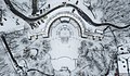
 Kyiv - Askold park upper wall in winter.jpg 2,048 × 1,536; 1.42 MB
-
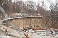
 Kyiv - Askold park upper wall.jpg 2,048 × 1,536; 1.45 MB
-

-
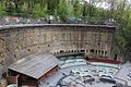
 Верхня напівкругла підпірна стіна з сучасною прибудовою та майданчиком.jpg 4,608 × 3,456; 3.5 MB
-
 Верхня напівкругла підпірна стіна, Київ.jpg 4,928 × 3,264; 7.57 MB
-
 Верхняя подпорная стена. Детали.jpg 3,024 × 2,074; 6.83 MB
-
 Верхняя подпорная стена.jpg 5,184 × 2,490; 15.94 MB
-
 Верхняя стена Зелёного театра (2).jpg 1,000 × 786; 1,015 KB
-
 Верхняя стена Зелёного театра (3).jpg 1,000 × 596; 603 KB
-
 Верхняя стена Зелёного театра (4).jpg 1,000 × 596; 805 KB
-
 Верхняя стена Зелёного театра.jpg 1,000 × 564; 686 KB
-
 Зелёный театр (4).jpg 1,000 × 592; 771 KB
-
 Зелёный театр (5).jpg 1,000 × 567; 771 KB
-
 Зелёный театр (6).jpg 1,000 × 586; 655 KB
-
 Київ, Паркова дорога, 2 01.jpg 5,184 × 3,456; 9.44 MB
-
 Київ, Паркова дорога, 2 02.jpg 5,184 × 3,456; 10.76 MB
-
 Нижняя подпорная стена. Детали.jpg 4,500 × 3,000; 11.81 MB
-
 Нижняя подпорная стена.jpg 4,000 × 2,667; 13.1 MB
-
 Парк Аскольдова могила 4007.JPG 4,272 × 2,848; 5.45 MB
-
 Паркова дорога 2.jpg 5,184 × 3,456; 11.52 MB
-
 Подільська брама колір 1892.jpg 1,378 × 819; 367 KB
-
 Стіна верхня напівкругла підпірна.JPG 1,024 × 768; 399 KB


_%D0%B7_%D0%B1%D1%96%D0%B9%D0%BD%D0%B8%D1%86%D1%8F%D0%BC%D0%B8,_%D0%B2%D1%96%D0%B4%D0%B4%D1%83%D1%88%D0%B8%D0%BD%D0%B0%D0%BC%D0%B8_%D1%82%D0%B0_%D0%B2%D1%85%D0%BE%D0%B4%D0%BE%D0%BC_%D0%B4%D0%BE_%D1%81%D1%82%D1%80%D1%96%D0%BB%D0%B5%D1%86%D1%8C%D0%BA%D0%BE%D1%97_%D0%B3%D0%B0%D0%BB%D0%B5%D1%80%D0%B5%D1%97.jpg)


.jpg)
.jpg)
.jpg)

.jpg)
.jpg)
.jpg)


