Category:Upplands runinskrifter 280
| Object location | | View all coordinates using: OpenStreetMap |
|---|
 | |||||
| Upload media | |||||
| Instance of |
| ||||
|---|---|---|---|---|---|
| Location | Hammarby socken, Uppland, Vallentuna hundred, Stockholm County, Sweden | ||||
| Heritage designation |
| ||||
 | |||||
|
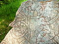
This is a category about an archaeological site or a monument in Sweden, number Hammarby 11:1 in the RAÄ Fornsök database. |
Media in category "Upplands runinskrifter 280"
The following 5 files are in this category, out of 5 total.
-
 Bautil 111 - U 280.png 1,844 × 2,702; 10.39 MB
-
 U280.jpg 1,024 × 719; 399 KB
-
 Upplands runinskrifter 280, 2015a.jpg 4,320 × 3,240; 5.82 MB
-
 Upplands runinskrifter 280, 2015b.jpg 4,320 × 3,240; 5.32 MB
-
 Upplands runinskrifter 280, 2015c.jpg 4,320 × 3,240; 5.61 MB


