Category:Utupua Island
island in Solomon Islands  | |||||
| Upload media | |||||
| Instance of | |||||
|---|---|---|---|---|---|
| Part of | |||||
| Location | Temotu Province, Solomon Islands | ||||
| Located in or next to body of water | |||||
| Width |
| ||||
| Length |
| ||||
| Population |
| ||||
| Area |
| ||||
 | |||||
Media in category "Utupua Island"
The following 9 files are in this category, out of 9 total.
-
 51F-37-008 - STS-51F - 51F earth observations - DPLA - 6068f34fec01f107d72f6cbdd53efe9a.jpg 5,700 × 5,900; 2.07 MB
-
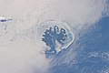 ISS036-E-5639 - View of the Solomon Islands.jpg 4,256 × 2,832; 899 KB
-
 ISS036-E-5640 - View of Earth.jpg 4,256 × 2,832; 917 KB
-
 ISS056-E-177559 - View of Earth.jpg 5,568 × 3,712; 2.58 MB
-
 ISS056-E-177560 - View of Earth.jpg 5,568 × 3,712; 2.07 MB
-
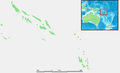 Solomon Islands - Utupua.PNG 932 × 565; 62 KB
-
 Tapoua Utupua 1876 map.jpg 1,343 × 1,266; 173 KB
-
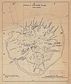 Utupua or Edgecumbe Island 1968 62.5K map.jpg 4,049 × 4,803; 4.84 MB
-
 Utupua STS51F.png 2,000 × 1,500; 2.07 MB


