Category:Venestraat 16, Nijkerk
| Object location | | View all coordinates using: OpenStreetMap |
|---|
 | |||||
| Upload media | |||||
| Instance of |
| ||||
|---|---|---|---|---|---|
| Location | Nijkerk, Gelderland, Netherlands | ||||
| Street address |
| ||||
| Located on street |
| ||||
| Heritage designation |
| ||||
 | |||||
|
This is a category about rijksmonument number 31016
|
| Address |
|
Media in category "Venestraat 16, Nijkerk"
The following 10 files are in this category, out of 10 total.
-
 Aanzicht, tekening - Nijkerk - 20166682 - RCE.jpg 888 × 1,200; 227 KB
-
 Achtergevel - Nijkerk - 20166680 - RCE.jpg 959 × 1,200; 332 KB
-
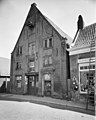
 Nijkerk-Venestraat 16.jpg 2,110 × 3,142; 875 KB
-
 Overzicht, gezien naar het noorden - Nijkerk - 20166674 - RCE.jpg 1,200 × 959; 221 KB
-
 Overzicht, reproductie van prentbriefkaart - Nijkerk - 20166677 - RCE.jpg 1,200 × 988; 253 KB
-
 Straatwand - Nijkerk - 20166676 - RCE.jpg 959 × 1,200; 214 KB
-
 Voorgevel - Nijkerk - 20166678 - RCE.jpg 962 × 1,200; 291 KB
-
 Voorgevel - Nijkerk - 20166681 - RCE.jpg 810 × 1,200; 235 KB
-
 Voorgevels - Nijkerk - 20166683 - RCE.jpg 1,200 × 809; 222 KB
-
 Zijgevel - Nijkerk - 20166679 - RCE.jpg 1,200 × 958; 333 KB


