Category:Vicarage of St John the Baptist, Tuebrook
| Object location | | View all coordinates using: OpenStreetMap |
|---|
This is a category about listed building number 1063779. |
building in Liverpool, Merseyside, England, UK  | |||||
| Upload media | |||||
| Instance of | |||||
|---|---|---|---|---|---|
| Location | Tuebrook, Liverpool, Merseyside, North West England, England | ||||
| Architect | |||||
| Heritage designation |
| ||||
| Inception |
| ||||
 | |||||
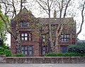
Grade II listed vicarage of St John the Baptist, Tuebrook, at the corner of Green Lane & Santon Avenue. c1870. by G.F. Bodley.
Media in category "Vicarage of St John the Baptist, Tuebrook"
The following 4 files are in this category, out of 4 total.
-
 Vicarage of St John the Baptist, Tuebrook 1.jpg 4,469 × 3,477; 8.69 MB
-
 Vicarage of St John the Baptist, Tuebrook 2.jpg 3,630 × 3,349; 4.68 MB
-
 Vicarage of St John the Baptist, Tuebrook 3.jpg 4,721 × 3,684; 9.44 MB
-
 Vicarage of St John the Baptist, Tuebrook 4.jpg 5,152 × 3,864; 8.4 MB


