Category:Visserstraat 55-57 (Groningen)
| Object location | | View all coordinates using: OpenStreetMap |
|---|
building in Groningen, Netherlands  | |||||
| Upload media | |||||
| Instance of | |||||
|---|---|---|---|---|---|
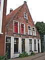
| Location | Groningen, Netherlands | ||||
| Street address |
| ||||
| Heritage designation |
| ||||
 | |||||
|
This is a category about rijksmonument number 18729
|
| Address |
|
Media in category "Visserstraat 55-57 (Groningen)"
The following 4 files are in this category, out of 4 total.
-
 Groningen Visserstraat 55-57 RM.jpg 2,102 × 3,520; 2.67 MB
-
 Groningen Visserstraat 55-57.JPG 2,448 × 3,264; 4.03 MB
-
 Overzicht - Groningen - 20094402 - RCE.jpg 1,197 × 1,200; 302 KB
-
 Voorgevel - Groningen - 20094403 - RCE.jpg 1,190 × 1,200; 311 KB


