Category:Voorstraat 20, Utrecht
| Object location | | View all coordinates using: OpenStreetMap |
|---|
 | |||||
| Upload media | |||||
| Instance of |
| ||||
|---|---|---|---|---|---|
| Location | Utrecht, Netherlands | ||||
| Heritage designation |
| ||||
 | |||||
|
This is a category about rijksmonument number 18382
|
| Address |
|
Media in category "Voorstraat 20, Utrecht"
The following 5 files are in this category, out of 5 total.
-
 Foto van tekening en detail uitvergroting - Utrecht - 20237144 - RCE.jpg 1,200 × 882; 156 KB
-
 Overzicht - Utrecht - 20237148 - RCE.jpg 1,200 × 956; 220 KB
-
 Voorgevel + overzicht - Utrecht - 20237147 - RCE.jpg 1,200 × 961; 217 KB
-
 Voorgevel - Utrecht - 20237146 - RCE.jpg 960 × 1,200; 238 KB
-
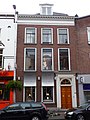 Voorstraat 20.JPG 2,592 × 3,456; 4.23 MB


