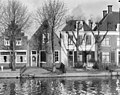
Category:Voorstraat 8, Vreeland
| Object location | | View all coordinates using: OpenStreetMap |
|---|
building in Stichtse Vecht, Netherlands  | |||||
| Upload media | |||||
| Instance of | |||||
|---|---|---|---|---|---|
| Location | Vreeland, Utrecht, Netherlands | ||||
| Street address |
| ||||
| Located on street |
| ||||
| Heritage designation |
| ||||
 | |||||
|
This is a category about rijksmonument number 26163
|
| Address |
|
Media in category "Voorstraat 8, Vreeland"
The following 7 files are in this category, out of 7 total.
-

-
 Voorgevel - Vreeland - 20247266 - RCE.jpg 802 × 1,200; 298 KB
-
 Voorgevel - Vreeland - 20247268 - RCE.jpg 951 × 1,200; 309 KB
-
 Voorgevel - Vreeland - 20247269 - RCE.jpg 1,200 × 953; 355 KB
-
 Voorgevel - Vreeland - 20247270 - RCE.jpg 947 × 1,200; 388 KB
-
 Voorgevel overzicht - Vreeland - 20247267 - RCE.jpg 1,200 × 953; 353 KB
-
 Vreeland - Voorstraat 8 RM26163.JPG 2,060 × 4,415; 1.15 MB


