Category:Voorstraat 84, Utrecht
| Object location | | View all coordinates using: OpenStreetMap |
|---|
building in Utrecht, Netherlands  | |||||
| Upload media | |||||
| Instance of | |||||
|---|---|---|---|---|---|
| Location | Utrecht, Netherlands | ||||
| Heritage designation |
| ||||
 | |||||
|
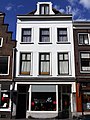
This is a category about rijksmonument number 450536
|
| Address |
|
Media in category "Voorstraat 84, Utrecht"
The following 4 files are in this category, out of 4 total.
-
 Exterieur VOORGEVEL - Utrecht - 20303522 - RCE.jpg 796 × 1,200; 186 KB
-
 Exterieur VOORGEVEL - Utrecht - 20303523 - RCE.jpg 788 × 1,200; 169 KB
-
 Voorstraat 84.JPG 2,592 × 3,456; 3.48 MB
-
 Voorstraat.84.Utrecht.jpg 2,921 × 3,894; 4.54 MB


