Category:Wörthsee
municipality of Germany    | |||||
| Upload media | |||||
| Pronunciation audio | |||||
|---|---|---|---|---|---|
| Instance of |
| ||||
| Part of |
| ||||
| Named after | |||||
| Location | Starnberg, Upper Bavaria, Bavaria, Germany | ||||
| Head of government |
| ||||
| Population |
| ||||
| Area |
| ||||
| Elevation above sea level |
| ||||
| Different from | |||||
| official website | |||||
 | |||||
Subcategories
This category has the following 7 subcategories, out of 7 total.
Pages in category "Wörthsee"
This category contains only the following page.
Media in category "Wörthsee"
The following 4 files are in this category, out of 4 total.
-
 Wappen Woerthsee.svg 315 × 323; 32 KB
-
 Wappenwoerthsee.jpg 200 × 183; 18 KB
-
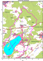 Woerthsee map.png 1,788 × 2,499; 1.72 MB
-
 Wörthsee in STA.svg 368 × 410; 289 KB

