Category:Wagenstraat 119, The Hague
| Object location | | View all coordinates using: OpenStreetMap |
|---|
building in The Hague, Netherlands  | |||||
| Upload media | |||||
| Instance of | |||||
|---|---|---|---|---|---|
| Location | The Hague, South Holland, Netherlands | ||||
| Street address |
| ||||
| Heritage designation |
| ||||
 | |||||
|
This is a category about rijksmonument number 18079
|
| Address |
|
Media in category "Wagenstraat 119, The Hague"
The following 7 files are in this category, out of 7 total.
-
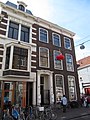 RM18079 Den Haag - Wagenstraat 119.jpg 2,448 × 3,264; 1.91 MB
-
 Wagenstr. 119 - 's-Gravenhage - 20091303 - RCE.jpg 802 × 1,200; 170 KB
-
 Wagenstr. 119, plafonds - 's-Gravenhage - 20091300 - RCE.jpg 868 × 1,200; 177 KB
-
 Wagenstr. 119, plafonds - 's-Gravenhage - 20091301 - RCE.jpg 1,200 × 863; 164 KB
-
 Wagenstr. 119, plafonds - 's-Gravenhage - 20091302 - RCE.jpg 1,200 × 870; 171 KB
-
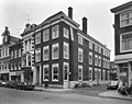 Wagenstr. 119-123, voorgevel - 's-Gravenhage - 20091305 - RCE.jpg 1,200 × 950; 219 KB
-
 Wagenstr. 119-123, zijgevel - 's-Gravenhage - 20091304 - RCE.jpg 1,200 × 951; 260 KB


