Category:Wallfahrtskirche Herrgottsruh (Friedberg)
| Object location | | View all coordinates using: OpenStreetMap |
|---|
This is the category of the Bavarian Baudenkmal (cultural heritage monument) with the ID D-7-71-130-28 (Wikidata)
|
church  | |||||
| Upload media | |||||
| Instance of | |||||
|---|---|---|---|---|---|
| Location | Friedberg, Aichach-Friedberg, Swabia, Bavaria, Germany | ||||
| Street address |
| ||||
| Architectural style | |||||
| Has part(s) |
| ||||
| Heritage designation | |||||
 | |||||
Subcategories
This category has the following 4 subcategories, out of 4 total.
Media in category "Wallfahrtskirche Herrgottsruh (Friedberg)"
The following 22 files are in this category, out of 22 total.
-
 Wallfahrtskirche Herrgottsruh - Friedberg (1).jpg 3,008 × 2,000; 2.93 MB
-
 Wallfahrtskirche Herrgottsruh - Friedberg (2).jpg 3,213 × 5,677; 7.02 MB
-
 Wallfahrtskirche Herrgottsruh - Friedberg (3).JPG 2,000 × 3,008; 3.32 MB
-
 Wallfahrtskirche Herrgottsruh - Friedberg (4).jpg 9,424 × 4,441; 16.07 MB
-
 Wallfahrtskirche Herrgottsruh - Friedberg (5).jpg 2,000 × 3,008; 2.89 MB
-
 Wallfahrtskirche Herrgottsruh - Friedberg (6).jpg 3,008 × 2,000; 4 MB
-
 Wallfahrtskirche Herrgottsruh - Friedberg (7).jpg 8,843 × 3,591; 13.08 MB
-
 Friedberg - Herrgottsruh.jpg 800 × 600; 95 KB
-
 Friedberg Herrgottsruh 11.jpg 800 × 566; 157 KB
-
 Friedberg Herrgottsruh 5.jpg 800 × 573; 131 KB
-
 Friedberg Herrgottsruh 6.jpg 800 × 600; 96 KB
-
 Friedberg Wallfahrtskirche Herrgottsruh 1260277.JPG 2,520 × 3,776; 5.81 MB
-
 Friedberg Wallfahrtskirche Herrgottsruh 2134.JPG 3,873 × 3,097; 6.63 MB
-
 Friedberg Wallfahrtskirche Herrgottsruh 2149.JPG 3,264 × 4,896; 8.11 MB
-
 Friedberg Wallfahrtskirche Herrgottsruh 2150.JPG 3,264 × 4,896; 6.69 MB
-
 Friedberg Wallfahrtskirche Herrgottsruh 2152.JPG 4,896 × 3,264; 7.13 MB
-
 Friedberg Wallfahrtskirche Herrgottsruh 2157.JPG 3,128 × 4,651; 7.06 MB
-
 Friedberg Wallfahrtskirche Herrgottsruh 2159.JPG 4,533 × 3,231; 7.96 MB
-
 Friedberg Wallfahrtskirche Herrgottsruh 2164.JPG 4,896 × 3,264; 7.48 MB
-
 Friedberg Wallfahrtskirche Herrgottsruh 2165.JPG 4,896 × 3,264; 8.83 MB
-
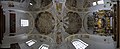
 Friedberg-Wallfahrtskirche unseres Herrn Ruhe, Chordeckenfreske.jpg 2,048 × 1,536; 523 KB
-
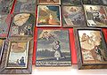
 Friedberg-Wallfahrtskirche unseres Herrn Ruhe, Votivtafeln und Beichtstuhl.jpg 2,048 × 1,536; 382 KB
.jpg)
.jpg)
.JPG)
.jpg)
.jpg)
.jpg)


.jpg)