Category:Wangford, East Suffolk
English: Wangford is a village in the civil parish of Wangford with Henham, in the Waveney district, in the county of Suffolk, England, just off the A12 trunk road on the edge of the Henham Park estate just outside Southwold.
village and former civil parish in East Suffolk, UK   | |||||
| Upload media | |||||
| Instance of |
| ||||
|---|---|---|---|---|---|
| Location | Wangford with Henham, East Suffolk, Suffolk, East of England, England | ||||
 | |||||
Subcategories
This category has the following 6 subcategories, out of 6 total.
Media in category "Wangford, East Suffolk"
The following 37 files are in this category, out of 37 total.
-
 'Green' landfill south of Wangford - geograph.org.uk - 252820.jpg 640 × 480; 79 KB
-
 B1126 Norfolk Road, Wangford - geograph.org.uk - 1138855.jpg 3,072 × 2,304; 1.37 MB
-
 B1126 Norfolk Road, Wangford - geograph.org.uk - 1138858.jpg 3,072 × 2,304; 1.42 MB
-
 Bluebells in Reydon Wood - geograph.org.uk - 251862.jpg 640 × 482; 179 KB
-
 Church Street, Wangford - geograph.org.uk - 3486416.jpg 3,072 × 2,304; 1.32 MB
-
 Church Street, Wangford - geograph.org.uk - 3487446.jpg 3,072 × 2,304; 1.33 MB
-
 Cottages in Church Street, Wangford - geograph.org.uk - 2078040.jpg 640 × 513; 96 KB
-
 Former coach house, Wangford Churchyard (listed building) - geograph.org.uk - 3509809.jpg 2,781 × 2,086; 1.64 MB
-
 High Street, Wangford - geograph.org.uk - 2078035.jpg 640 × 485; 92 KB
-
 High Street, Wangford - geograph.org.uk - 3486481.jpg 2,757 × 2,068; 902 KB
-
 High Street, Wangford - geograph.org.uk - 3486484.jpg 3,072 × 2,304; 1.61 MB
-
 High Street, Wangford - geograph.org.uk - 3486521.jpg 3,072 × 2,304; 1.4 MB
-
 High Street, Wangford - geograph.org.uk - 3486843.jpg 3,072 × 2,304; 1.43 MB
-
 High Street, Wangford - geograph.org.uk - 3486872.jpg 3,072 × 2,304; 1.25 MB
-
 High Street, Wangford - geograph.org.uk - 3487459.jpg 3,072 × 2,190; 1.3 MB
-
 High Street, Wangford - geograph.org.uk - 3489628.jpg 3,072 × 2,304; 1.26 MB
-
 Swan House in High Street, Wangford - geograph.org.uk - 2078037.jpg 640 × 480; 118 KB
-
 Telephone Box on the High Street - geograph.org.uk - 3486836.jpg 2,304 × 3,072; 1.46 MB
-
 Telephone Box ^ Wangford Telephone Exchange - geograph.org.uk - 3486537.jpg 3,072 × 2,304; 1.46 MB
-
 The (former) Post Office in Wangford - geograph.org.uk - 2078047.jpg 640 × 496; 89 KB
-
 The A12 at Wangford - geograph.org.uk - 1906834.jpg 640 × 480; 255 KB
-
 The A12 at Wangford - geograph.org.uk - 1906837.jpg 640 × 480; 251 KB
-

-
 Wangford Community Centre - geograph.org.uk - 1138796.jpg 3,072 × 2,304; 1.35 MB
-
 Wangford cottages - geograph.org.uk - 439632.jpg 640 × 480; 111 KB
-
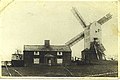 Wangford post mill 1859.jpg 458 × 304; 116 KB
-
 Wangford Surgery - geograph.org.uk - 3486409.jpg 3,072 × 2,304; 1.4 MB
-
 Wangford Surgery sign - geograph.org.uk - 3486410.jpg 2,304 × 3,072; 1.49 MB
-
 Wangford Telephone Exchange - geograph.org.uk - 3486545.jpg 2,196 × 2,928; 1.44 MB
-
 Wangford Veterinary Clinic - geograph.org.uk - 3487466.jpg 2,304 × 2,814; 1.28 MB
-
 Wangford windmill.jpg 1,052 × 1,653; 359 KB
-
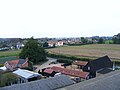 Wangford.jpg 3,072 × 2,304; 1.23 MB
-
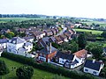
 Wangford1.jpg 3,072 × 2,304; 1.43 MB
-
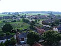
 Wangford2.jpg 3,072 × 2,304; 1.38 MB
-
 Wangford3.jpg 3,072 × 2,304; 1.3 MB
-
 Wangford4.jpg 3,072 × 2,304; 1.13 MB
-
 Well at Well Cottage, Wangford - geograph.org.uk - 3509839.jpg 2,315 × 2,315; 2.29 MB


_-_geograph.org.uk_-_3509809.jpg)


_Post_Office_in_Wangford_-_geograph.org.uk_-_2078047.jpg)


