Category:Watermill in Antoniv (upstream)
| Object location | | View all coordinates using: OpenStreetMap |
|---|
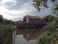
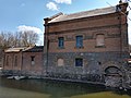
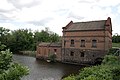
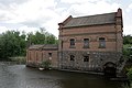
Українська: Водяний млин 19 століття в селі Антонів Сквирського району Київської області, на річці Березянка. Крім цього млина (більшого й розташованого вище за течією [західніше]), в селі є ще один (менший і розташований нижче за течією).
English: Watermill of 19 century in Antoniv village of Kiev Oblast (Ukraine), on Berezianka river. There are 2 watermills in the village: this one (bigger and located upstream [to the west]) and other one (smaller and located downstream).
 | |||||
| Upload media | |||||
| Instance of | |||||
|---|---|---|---|---|---|
| Location | Antoniv, Bila Tserkva Raion, Kyiv Oblast, Ukraine | ||||
 | |||||
Media in category "Watermill in Antoniv (upstream)"
The following 28 files are in this category, out of 28 total.
-
 Antoniv 1.jpg 1,152 × 864; 247 KB
-
 Antoniv 2.jpg 1,152 × 864; 246 KB
-
 Антонів діючий.jpg 2,776 × 2,304; 2.34 MB
-
 Антонів, верхній млин 1 (1).jpg 3,072 × 2,304; 3.24 MB
-
 Антонів, верхній млин 1 (2).jpg 3,072 × 2,304; 2.84 MB
-
 Антонів, верхній млин 1 (3).jpg 3,072 × 2,304; 3.25 MB
-
 Антонів, колишній млин, тепер олійниця 01.jpg 2,400 × 3,200; 2.69 MB
-
 Антонів, колишній млин, тепер олійниця 02.jpg 3,200 × 2,400; 3.04 MB
-
 Антонів, колишній млин, тепер олійниця 03.jpg 3,200 × 2,400; 3.17 MB
-
 Антонів, колишній млин, тепер олійниця 04.jpg 3,200 × 2,400; 3.29 MB
-
 Антонів, колишній млин, тепер олійниця 05.jpg 3,200 × 2,400; 3.14 MB
-
 Водяний млин (мур.) (верхній).jpg 3,246 × 2,199; 3.52 MB
-
 Водяний млин (мур.).jpg 3,382 × 2,254; 3.04 MB
-
 Водяний млин с.Антонів.jpg 3,888 × 2,592; 5.33 MB
-
 Водяний млин с.Антонів1.jpg 3,888 × 2,592; 4.73 MB
-
 Водяний млин с.Антонів11.jpg 3,888 × 2,592; 4.67 MB
-
 Водяний млин у с. Антонів Сквирського району.jpg 3,984 × 2,656; 7.17 MB
-
 Водяний млин121.jpg 3,888 × 2,592; 4.61 MB
-
 Водяний млин133.jpg 3,072 × 2,304; 1.51 MB
-
 Водяний млин212.jpg 3,072 × 2,304; 1.44 MB
-
 Млин в Антонів 1.jpg 6,000 × 4,000; 17.99 MB
-
 Млин в Антонів 2.jpg 6,000 × 4,000; 19.83 MB
-
 Млин в Антонів 3.jpg 6,000 × 4,000; 17.57 MB
-
 Млин в Антонів 4.jpg 10,420 × 7,706; 56.16 MB
-
 Млин в Антонів 5.jpg 6,000 × 4,000; 22.73 MB
-
 Млин в Антонів 6.jpg 6,000 × 4,000; 28.49 MB
-
 Млин в Антонів 7.jpg 6,000 × 4,000; 20.23 MB
-
 Млин в Антонів 8.jpg 4,254 × 3,156; 11.8 MB


.jpg)
.jpg)
.jpg)


_(%D0%B2%D0%B5%D1%80%D1%85%D0%BD%D1%96%D0%B9).jpg)
.jpg)


