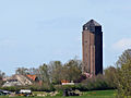
Category:Watertoren (Tuk)
| Object location | | View all coordinates using: OpenStreetMap |
|---|
 | |||||
| Upload media | |||||
| Instance of | |||||
|---|---|---|---|---|---|
| Location | Tuk, Steenwijkerland, Overijssel, Netherlands | ||||
| Street address |
| ||||
| Located on street |
| ||||
| Heritage designation |
| ||||
 | |||||
|
This is a category about rijksmonument number 508646
|
| Address |
|
Media in category "Watertoren (Tuk)"
The following 5 files are in this category, out of 5 total.
-
 20140416 Zicht op watertoren van Tuk.jpg 4,858 × 3,644; 2.47 MB
-
 20140416 Zicht op watertoren van Tuk2.jpg 4,307 × 3,230; 1.46 MB
-
 Overzicht watertoren - Tuk - 20350297 - RCE.jpg 1,172 × 1,200; 307 KB
-
 Overzicht watertoren - Tuk - 20350476 - RCE.jpg 1,176 × 1,200; 407 KB
-
 Watertoren Steenwijkerwold 07.JPG 576 × 768; 65 KB


