Category:Weerderhuys (Valkenswaard)
| Object location | | View all coordinates using: OpenStreetMap |
|---|
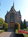
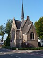
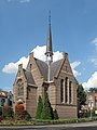
Nederlands: Ned. Herv. Kerk of Weerderhuys, Valkenswaard - anno 1890 - In gebruik als trouwzaal
church in Valkenswaard, Netherlands  | |||||
| Upload media | |||||
| Instance of | |||||
|---|---|---|---|---|---|
| Location | Valkenswaard, North Brabant, Netherlands | ||||
| Street address |
| ||||
 | |||||
|
This is a category about rijksmonument number 518661
|
| Address |
|
Media in category "Weerderhuys (Valkenswaard)"
The following 5 files are in this category, out of 5 total.
-
 Ned Hervormde Kerk Markt 2 Valkenswaard.jpg 3,240 × 4,320; 5 MB
-
 Ned Hervormde Kerk Valkenswaard.jpg 3,240 × 4,320; 4.86 MB
-
 Overzicht - Valkenswaard - 20238450 - RCE.jpg 788 × 1,200; 201 KB
-

-
 Valkenswaard, Nederlands Hervormde Kerk- het Weerderhuis foto10 2011-09-03 15.42.JPG 3,296 × 4,395; 9.12 MB


