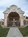
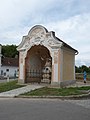
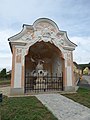
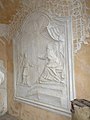
Category:Wegkapelle Johannes Nepomuk Straß im Straßertale
| Object location | | View all coordinates using: OpenStreetMap |
|---|
building in Straß im Straßertale, Austria  | |||||
| Upload media | |||||
| Instance of | |||||
|---|---|---|---|---|---|
| Location | Straß im Straßertale, Krems District, Lower Austria, Austria | ||||
| Street address |
| ||||
| Heritage designation | |||||
 | |||||
Wegkapelle hl. Johannes Nepomuk, Retzer Straße (B35), Straß im Straßertale, Niederösterreich
Media in category "Wegkapelle Johannes Nepomuk Straß im Straßertale"
The following 20 files are in this category, out of 20 total.
-
 GuentherZ 2011-06-04 0037 Strass im Strassertal JN-Kapelle.jpg 1,800 × 974; 1.38 MB
-
 GuentherZ 2011-06-04 0038 Strass im Strassertal JN-Kapelle.jpg 1,707 × 1,800; 1.68 MB
-
 GuentherZ 2011-06-04 0039 Strass im Strassertal JN-Kapelle.jpg 1,220 × 1,800; 1.26 MB
-
 Straß im Straßertale Wegkapelle Johannes Nepomuk01.jpg 3,000 × 4,000; 3.88 MB
-
 Straß im Straßertale Wegkapelle Johannes Nepomuk02.jpg 3,000 × 4,000; 4.04 MB
-
 Straß im Straßertale Wegkapelle Johannes Nepomuk03.jpg 3,000 × 4,000; 4.06 MB
-
 Straß im Straßertale Wegkapelle Johannes Nepomuk04.jpg 3,000 × 4,000; 3.96 MB
-
 Straß im Straßertale Wegkapelle Johannes Nepomuk05.jpg 3,000 × 4,000; 4 MB
-
 Straß im Straßertale Wegkapelle Johannes Nepomuk06.jpg 3,000 × 4,000; 4.05 MB
-
 Straß im Straßertale Wegkapelle Johannes Nepomuk07.jpg 3,000 × 4,000; 4.07 MB
-
 Straß im Straßertale Wegkapelle Johannes Nepomuk08.jpg 3,000 × 4,000; 3.83 MB
-
 Straß im Straßertale Wegkapelle Johannes Nepomuk09.jpg 4,000 × 3,000; 4.48 MB
-
 Straß im Straßertale Wegkapelle Johannes Nepomuk10.jpg 4,000 × 3,000; 4.21 MB
-
 Straß im Straßertale Wegkapelle Johannes Nepomuk11.jpg 3,000 × 4,000; 4.03 MB
-
 Straß im Straßertale Wegkapelle Johannes Nepomuk12.jpg 3,000 × 4,000; 4.1 MB
-
 Straß im Straßertale Wegkapelle Johannes Nepomuk13.jpg 3,000 × 4,000; 4.05 MB
-
 Straß im Straßertale Wegkapelle Johannes Nepomuk14.jpg 3,000 × 4,000; 3.88 MB
-
 Straß im Straßertale Wegkapelle Johannes Nepomuk15.jpg 3,000 × 4,000; 3.98 MB
-
 Straß im Straßertale Wegkapelle Johannes Nepomuk16.jpg 4,000 × 3,000; 4.33 MB
-
 Straß im Straßertale Wegkapelle Johannes Nepomuk17.jpg 3,000 × 4,000; 3.78 MB


