Category:Wellgerguat, Altenmarkt bei Sankt Gallen
| Object location | | View all coordinates using: OpenStreetMap |
|---|
 | |||||
| Upload media | |||||
| Instance of | |||||
|---|---|---|---|---|---|
| Location | Altenmarkt bei Sankt Gallen, Liezen District, Styria, Austria | ||||
| Street address |
| ||||
| Heritage designation | |||||
 | |||||
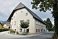
Deutsch: Ehem. Pfarrhof, Wellergut
Media in category "Wellgerguat, Altenmarkt bei Sankt Gallen"
The following 4 files are in this category, out of 4 total.
-
 Altenmarkt St Gallen Wellergut.JPG 4,288 × 2,848; 3.55 MB
-
 Wellgerguat 01, Altenmarkt bei Sankt Gallen.jpg 4,477 × 3,157; 6.92 MB
-
 Wellgerguat 02, Altenmarkt bei Sankt Gallen.jpg 2,984 × 4,808; 9.55 MB
-
 Wellgerguat 03, Altenmarkt bei Sankt Gallen.jpg 3,664 × 3,208; 6.07 MB


