Category:Welton, Lincolnshire
English: Welton (or Welton by Lincoln) is a village and civil parish seven miles north of the city of Lincoln in the county of Lincolnshire, England, and the district of West Lindsey. The longer name Welton by Lincoln serves to distinguish it from two other Weltons in Lincolnshire, Welton le Wold and Welton le Marsh, and other Weltons elsewhere in England.
village and civil parish in Lincolnshire, UK  | |||||
| Upload media | |||||
| Instance of | |||||
|---|---|---|---|---|---|
| Location | West Lindsey, Lincolnshire, East Midlands, England | ||||
 | |||||
Subcategories
This category has the following 5 subcategories, out of 5 total.
Media in category "Welton, Lincolnshire"
The following 198 files are in this category, out of 198 total.
-
 A wide Junction on A46 - geograph.org.uk - 3342606.jpg 2,256 × 1,504; 1.52 MB
-
 A15 - geograph.org.uk - 5350376.jpg 640 × 426; 84 KB
-
 A46 heading south, Snarford Bridge - geograph.org.uk - 3654770.jpg 640 × 480; 48 KB
-
 Alone in the snow - geograph.org.uk - 2797796.jpg 1,024 × 768; 177 KB
-
 Another drain, Snarford Bridge - geograph.org.uk - 3654765.jpg 640 × 480; 59 KB
-
 Baden Hall, Welton by Lincoln - geograph.org.uk - 4072986.jpg 1,600 × 1,064; 589 KB
-
 Beck in Welton.jpg 3,120 × 4,160; 2.94 MB
-
 Bends in Horncastle Lane - geograph.org.uk - 4154035.jpg 640 × 480; 46 KB
-
 Butcher's Cottage - geograph.org.uk - 4402593.jpg 1,024 × 683; 250 KB
-
 Church Lane, Welton - geograph.org.uk - 5810880.jpg 1,024 × 768; 150 KB
-
 Clancydocwra on Hackthorn Road, Welton - geograph.org.uk - 4073026.jpg 1,600 × 1,064; 722 KB
-
 Cottage on Lincoln Road - geograph.org.uk - 2056462.jpg 640 × 426; 86 KB
-
 Crop field off Heath Lane - geograph.org.uk - 4153982.jpg 640 × 480; 63 KB
-
 Crop field off Mill Lane - geograph.org.uk - 3654838.jpg 640 × 480; 87 KB
-
 Cut Mark, Welton, Near South Farm - geograph.org.uk - 4212518.jpg 960 × 1,280; 544 KB
-
 Cut Mark, Welton, Near South Farm - geograph.org.uk - 4212521.jpg 960 × 1,280; 326 KB
-
 Cut Mark, Welton, Old School - geograph.org.uk - 4212511.jpg 960 × 1,280; 418 KB
-
 Cut Mark, Welton, Ryland Road - geograph.org.uk - 4280732.jpg 960 × 1,280; 424 KB
-

-

-
 Drain, Snarford Bridge - geograph.org.uk - 3654761.jpg 640 × 480; 93 KB
-
 Dunholme Road from Ryland Road, Dunholme - geograph.org.uk - 5793631.jpg 1,600 × 1,065; 591 KB
-
 East end of Cliff Road, Welton - geograph.org.uk - 5810875.jpg 1,024 × 768; 150 KB
-
 Eastfield Close - geograph.org.uk - 2797824.jpg 1,024 × 768; 142 KB
-
 Eastfield lane - geograph.org.uk - 3271951.jpg 1,280 × 960; 345 KB
-
 Eastfield Lane - geograph.org.uk - 3654812.jpg 640 × 480; 60 KB
-
 Eastfield Lane heading west - geograph.org.uk - 3654788.jpg 640 × 480; 90 KB
-
 Eastfield Lane heading west - geograph.org.uk - 3654799.jpg 640 × 480; 57 KB
-
 Eastfield Lane looking towards A46 - geograph.org.uk - 2455730.jpg 640 × 480; 83 KB
-

-
 Eastfield Lane, Welton - geograph.org.uk - 5810894.jpg 1,024 × 768; 154 KB
-
 Entering Welton - geograph.org.uk - 2524684.jpg 1,280 × 960; 495 KB
-
 Entering Welton by Lincoln - geograph.org.uk - 4072898.jpg 1,600 × 1,064; 754 KB
-
 Entrance to West Hall Farm off Heath Lane - geograph.org.uk - 4072896.jpg 1,600 × 1,064; 789 KB
-
 Farm gate off Eastfield Lane near Welton Hill - geograph.org.uk - 3383731.jpg 1,024 × 768; 121 KB
-
 Farm track off Eastfield Lane - geograph.org.uk - 3654795.jpg 640 × 480; 77 KB
-
 Farmland near Welton - geograph.org.uk - 3654809.jpg 640 × 480; 99 KB
-
 Farmland off Eastfield Lane - geograph.org.uk - 3654784.jpg 640 × 480; 86 KB
-
 Farmland off Eastfield Lane - geograph.org.uk - 3654798.jpg 640 × 480; 63 KB
-
 Farmland, Glebe Farm - geograph.org.uk - 4153996.jpg 640 × 480; 69 KB
-
 Field and hedgerow - geograph.org.uk - 4154044.jpg 640 × 480; 84 KB
-
 Field entrance off Horncastle Lane - geograph.org.uk - 4154037.jpg 640 × 480; 97 KB
-
 Field of oilseed rape at Welton - geograph.org.uk - 5579445.jpg 1,024 × 768; 159 KB
-
 Fields off Horncastle Lane - geograph.org.uk - 3253604.jpg 2,256 × 1,504; 777 KB
-
 Footbridge over Stream - geograph.org.uk - 2375249.jpg 800 × 600; 119 KB
-
 Footpath off Horncastle Lane - geograph.org.uk - 4154048.jpg 640 × 446; 87 KB
-
 Free Church, Snarford Bridge - geograph.org.uk - 3654771.jpg 640 × 480; 74 KB
-
 Gated Track off Mill Lane - geograph.org.uk - 2859102.jpg 682 × 1,024; 175 KB
-
 Grange de Lings farmland - geograph.org.uk - 1266584.jpg 640 × 426; 66 KB
-
 Grange de Lings footpath - geograph.org.uk - 1266577.jpg 640 × 426; 97 KB
-
 Grazing off Hackthorn Road - geograph.org.uk - 3654828.jpg 640 × 480; 87 KB
-
 Green at Welton from the church tower.jpg 1,078 × 669; 400 KB
-
 Hackthorn Road - geograph.org.uk - 3654822.jpg 640 × 480; 74 KB
-
 Hackthorn Road - geograph.org.uk - 3654832.jpg 640 × 480; 64 KB
-
 Hackthorn Road from Mill Lane - geograph.org.uk - 5771187.jpg 1,600 × 1,065; 711 KB
-
 Hackthorn Road, Welton by Lincoln - geograph.org.uk - 4073000.jpg 1,600 × 1,023; 591 KB
-
 Hackthorn Road, Welton, 1 - geograph.org.uk - 6025546.jpg 1,600 × 901; 749 KB
-
 Hackthorn Road, Welton, 2 - geograph.org.uk - 6025547.jpg 1,600 × 901; 653 KB
-
 Hackthorne Road approaching Welton - geograph.org.uk - 2859223.jpg 1,209 × 786; 906 KB
-
 Hackthorne Road, near Welton - geograph.org.uk - 2859105.jpg 1,280 × 853; 426 KB
-
 Heath Lane - geograph.org.uk - 2797812.jpg 1,024 × 768; 162 KB
-
 Heath Lane - geograph.org.uk - 3253599.jpg 2,256 × 1,504; 1,019 KB
-
 Heath Lane - geograph.org.uk - 3915882.jpg 1,024 × 504; 94 KB
-
 Heath Lane - geograph.org.uk - 4153969.jpg 640 × 480; 66 KB
-
 Heath Lane - geograph.org.uk - 4153979.jpg 640 × 480; 59 KB
-
 Heath Lane - geograph.org.uk - 4153984.jpg 640 × 480; 67 KB
-
 Heath Lane near Old Man's Head Spring - geograph.org.uk - 3915886.jpg 1,024 × 768; 156 KB
-
 Heath Lane near Welton - geograph.org.uk - 3915889.jpg 1,024 × 768; 159 KB
-
 Heath Lane towards Welton - geograph.org.uk - 4072891.jpg 1,600 × 1,064; 534 KB
-
 Heath Lane towards Welton - geograph.org.uk - 4072894.jpg 1,600 × 1,064; 864 KB
-
 Heath Lane, Welton - geograph.org.uk - 3654872.jpg 640 × 480; 61 KB
-

-
 Horncastle Lane - geograph.org.uk - 2167056.jpg 1,024 × 768; 190 KB
-
 Horncastle Lane - geograph.org.uk - 3253607.jpg 2,256 × 1,504; 1.6 MB
-
 Horncastle Lane - geograph.org.uk - 4153994.jpg 640 × 480; 83 KB
-
 Horncastle Lane - geograph.org.uk - 4154032.jpg 640 × 480; 68 KB
-
 Horncastle Lane - geograph.org.uk - 4154049.jpg 640 × 480; 66 KB
-
 Horncastle Lane looking east - geograph.org.uk - 2167066.jpg 1,024 × 768; 170 KB
-
 House - geograph.org.uk - 783891.jpg 640 × 480; 45 KB
-
 House in Sudbeck lane - geograph.org.uk - 2455697.jpg 640 × 427; 84 KB
-
 Houses on Rivehall Avenue, Welton - geograph.org.uk - 3654854.jpg 640 × 480; 75 KB
-
 Island Gas Ltd. oil well - geograph.org.uk - 4155246.jpg 640 × 427; 75 KB
-
-
 Kedgeree Fish and chip shop - geograph.org.uk - 742121.jpg 640 × 480; 72 KB
-
 Lincoln Road from Sudbeck Lane - geograph.org.uk - 2455694.jpg 640 × 427; 69 KB
-
 Lincoln Road, Welton by Lincoln - geograph.org.uk - 4072935.jpg 1,600 × 1,064; 551 KB
-
 Lincolnshire farmland near RAF Scampton - geograph.org.uk - 3915879.jpg 1,024 × 513; 94 KB
-
 Maize crop - geograph.org.uk - 4153963.jpg 640 × 480; 82 KB
-
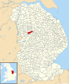 Map of Welton Civil Parish in Lincolnshire.svg 813 × 980; 3.69 MB
-
 Map of Welton Rural electoral division (2017).svg 815 × 980; 1.75 MB
-
 Methodist Chapel on Cliff Road, Welton by Lincoln - geograph.org.uk - 4072905.jpg 1,600 × 1,064; 436 KB
-
 Methodist Church, Welton - geograph.org.uk - 3654875.jpg 640 × 480; 69 KB
-
 Methodist church, Welton - geograph.org.uk - 5810867.jpg 1,024 × 768; 148 KB
-
 Mill House - geograph.org.uk - 2956706.jpg 640 × 480; 129 KB
-
 Mill Lane - geograph.org.uk - 2956689.jpg 640 × 480; 137 KB
-
 Mill Lane - geograph.org.uk - 3654843.jpg 640 × 480; 75 KB
-
 Mill Lane towards Hackthorn Road - geograph.org.uk - 5771176.jpg 1,600 × 1,065; 480 KB
-
 My new house - geograph.org.uk - 775639.jpg 640 × 480; 75 KB
-
 New hedge on Welton Heath - geograph.org.uk - 2797816.jpg 1,024 × 768; 174 KB
-
 New housing on Hackthorn Road - geograph.org.uk - 3654818.jpg 640 × 480; 62 KB
-
 Nodding Donkey at Scampton C Oilwell - geograph.org.uk - 2375223.jpg 800 × 600; 102 KB
-
 Nodding donkeys - geograph.org.uk - 2147921.jpg 1,024 × 768; 159 KB
-
 Norbeck Lane, Welton - geograph.org.uk - 3654861.jpg 640 × 480; 48 KB
-
 Old Mans Spring, Welton - geograph.org.uk - 2375200.jpg 640 × 480; 129 KB
-
 Ordnance Survey Cut Mark - geograph.org.uk - 5480273.jpg 640 × 412; 127 KB
-
 Outskirts of Welton - geograph.org.uk - 215223.jpg 640 × 480; 111 KB
-
 Path through the cemetery at Saint Mary's church in Welton.jpg 3,264 × 2,448; 3.54 MB
-
 Prebend Lane - geograph.org.uk - 5578511.jpg 1,024 × 768; 181 KB
-
 Prebend Lane, Welton - geograph.org.uk - 2375208.jpg 450 × 600; 99 KB
-
 Prebend Lane, Welton - geograph.org.uk - 3654856.jpg 640 × 480; 48 KB
-
 Prebend Lane, Welton - geograph.org.uk - 5810850.jpg 1,024 × 768; 192 KB
-
 Public footpath off Eastfield Lane, Welton - geograph.org.uk - 5810888.jpg 1,024 × 768; 234 KB
-
 Public Footpath off Horncastle Lane - geograph.org.uk - 2448750.jpg 1,024 × 768; 670 KB
-
 Pump On The Green.jpg 3,120 × 4,160; 5.05 MB
-
 RAF memorial window in St Mary's Church, Welton - geograph.org.uk - 5901565.jpg 1,158 × 1,600; 670 KB
-
 Rivehall Avenue, Welton (1) - geograph.org.uk - 5810842.jpg 1,024 × 768; 133 KB
-
 Rivehall Avenue, Welton (2) - geograph.org.uk - 5810844.jpg 1,024 × 768; 133 KB
-
 Rivehall Avenue, Welton - geograph.org.uk - 3654845.jpg 640 × 480; 59 KB
-
 Rivehall Avenue, Welton - geograph.org.uk - 3654850.jpg 640 × 480; 63 KB
-

-
 Road to Brink Hall Farm - geograph.org.uk - 2860571.jpg 682 × 1,024; 148 KB
-
 Ryland House - geograph.org.uk - 2797832.jpg 1,024 × 768; 179 KB
-

-
 South end of Prebend Lane, Welton - geograph.org.uk - 5810856.jpg 1,024 × 768; 183 KB
-
 St Martin's church in Welton.jpeg 400 × 267; 50 KB
-
 St Mary's Church, Welton - geograph.org.uk - 5785471.jpg 1,065 × 1,600; 502 KB
-
 St Mary's Church, Welton - geograph.org.uk - 5901551.jpg 1,065 × 1,600; 329 KB
-
 St Mary's Church, Welton - geograph.org.uk - 5901573.jpg 1,061 × 1,600; 670 KB
-
 St Mary's Church, Welton - geograph.org.uk - 5901578.jpg 1,600 × 1,065; 447 KB
-
 St Mary's Church, Welton - geograph.org.uk - 5901587.jpg 1,065 × 1,600; 440 KB
-
 St Mary's Church, Welton - geograph.org.uk - 5902073.jpg 1,600 × 1,065; 492 KB
-
 St Mary's Church, Welton - geograph.org.uk - 5902077.jpg 732 × 1,600; 586 KB
-
 St Mary's Church, Welton - geograph.org.uk - 5902083.jpg 934 × 1,600; 684 KB
-
 St Mary's Church, Welton - geograph.org.uk - 5902087.jpg 781 × 1,600; 653 KB
-
 Stonecliffe House.jpg 4,160 × 3,120; 3.39 MB
-
 Stubble field off Horncastle Lane - geograph.org.uk - 4154046.jpg 640 × 480; 61 KB
-
 Stubble field, Cliffe Farm - geograph.org.uk - 4153973.jpg 640 × 480; 58 KB
-
 Suburban housing on the edge of Welton - geograph.org.uk - 5579420.jpg 1,024 × 768; 175 KB
-
 Sudbeck Lane - geograph.org.uk - 4402597.jpg 1,024 × 683; 303 KB
-
 Sun shadows and a puddle - geograph.org.uk - 1432362.jpg 640 × 427; 68 KB
-
 Tank traps - geograph.org.uk - 739269.jpg 640 × 427; 68 KB
-

-
 The A15 at the junction of Heath Lane - geograph.org.uk - 5654196.jpg 2,048 × 1,536; 1.47 MB
-
 The end of the road - geograph.org.uk - 2147890.jpg 1,024 × 768; 167 KB
-
 The Falconer - geograph.org.uk - 3654825.jpg 640 × 480; 68 KB
-
 The Falconer at Welton Manor Golf Centre - geograph.org.uk - 5793622.jpg 1,600 × 1,065; 802 KB
-
 The Farmers Arms, Welton Hill - geograph.org.uk - 3654775.jpg 640 × 480; 65 KB
-
 The Green, Welton - geograph.org.uk - 2797726.jpg 1,024 × 768; 168 KB
-
 The Hardings, Welton - geograph.org.uk - 744254.jpg 640 × 480; 99 KB
-
 The lane to Brink Hall - geograph.org.uk - 2797792.jpg 1,024 × 768; 128 KB
-
 The Lane to Brink Hall - geograph.org.uk - 2797803.jpg 1,024 × 768; 257 KB
-
 The Welton Village Hall - geograph.org.uk - 4072981.jpg 1,600 × 1,064; 546 KB
-
 The Welton Village Hall - geograph.org.uk - 4072990.jpg 1,600 × 1,064; 536 KB
-
 To Glebe Farm - geograph.org.uk - 1266547.jpg 640 × 426; 67 KB
-
 Track from Mill Lane - geograph.org.uk - 2956715.jpg 640 × 480; 104 KB
-
 Track to Cliffe Farm - geograph.org.uk - 4153976.jpg 640 × 480; 38 KB
-
 Track to Cliffe Farm off Heath Lane - geograph.org.uk - 2860611.jpg 682 × 864; 455 KB
-
 Track to Diamond Farm from Eastfield Lane - geograph.org.uk - 2524591.jpg 1,280 × 960; 380 KB
-
 Track to Glebe Farm - geograph.org.uk - 4153998.jpg 640 × 480; 65 KB
-
 Track towards Diamond Farm - geograph.org.uk - 3654785.jpg 640 × 480; 68 KB
-
 Tree on Horncastle Lane - geograph.org.uk - 2167104.jpg 1,024 × 768; 206 KB
-
 View towards Diamond Farm - geograph.org.uk - 2147934.jpg 1,024 × 768; 124 KB
-
 Village pump at Welton By Lincoln - geograph.org.uk - 2455689.jpg 427 × 640; 95 KB
-
 Welton and Dunholme Methodist chapel - geograph.org.uk - 2797722.jpg 1,024 × 768; 154 KB
-
 Welton Cliff - geograph.org.uk - 1089098.jpg 640 × 427; 67 KB
-
 Welton Cliff - geograph.org.uk - 1089099.jpg 640 × 427; 86 KB
-
 Welton Cliff - geograph.org.uk - 739275.jpg 640 × 427; 56 KB
-
 Welton Heath - geograph.org.uk - 1631021.jpg 640 × 426; 67 KB
-
 Welton Heath sunset - geograph.org.uk - 3244975.jpg 640 × 427; 32 KB
-
 Welton Heath sunset - geograph.org.uk - 5615879.jpg 1,024 × 683; 80 KB
-
 Welton Library.jpg 4,032 × 3,024; 2.84 MB
-
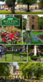 Welton Montage.png 796 × 1,500; 2.96 MB
-
 Welton Pumping Station - geograph.org.uk - 5578505.jpg 1,024 × 768; 192 KB
-
 Welton St. Marys Primary School - geograph.org.uk - 742176.jpg 640 × 480; 70 KB
-
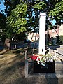
 Welton War Memorial - geograph.org.uk - 5786593.jpg 1,065 × 1,600; 824 KB
-
 West end of Cliff Road, Welton - geograph.org.uk - 5810860.jpg 1,024 × 768; 178 KB
-
 West end of Eagle Drive, Welton - geograph.org.uk - 5810841.jpg 1,024 × 768; 170 KB
-
 West end of Hazel Grove, Welton - geograph.org.uk - 5810853.jpg 1,024 × 768; 154 KB
-
 Wetmoor Lane - geograph.org.uk - 2147949.jpg 1,024 × 768; 154 KB
-
 Wheat field in Lincolnshire.jpg 4,160 × 3,120; 3.74 MB
-
 Wheatmore Farm - geograph.org.uk - 2147963.jpg 1,024 × 768; 139 KB
-

-
 Will farr download (1).jpg 187 × 270; 5 KB
-
 Winter on Welton Heath - geograph.org.uk - 2797789.jpg 1,024 × 768; 254 KB
-
 WWII airfield information sign - geograph.org.uk - 3714411.jpg 3,648 × 2,736; 2.7 MB
-
 Cliff Road - geograph.org.uk - 482766.jpg 640 × 427; 67 KB
-

-
 Give Way ahead - geograph.org.uk - 1432355.jpg 640 × 403; 53 KB
-
 Heath Road Bend - geograph.org.uk - 425761.jpg 640 × 480; 95 KB
-
 Heath Road near Dunholme, Lincolnshire - geograph.org.uk - 186717.jpg 640 × 427; 106 KB
-
 Lincoln Road - geograph.org.uk - 482776.jpg 640 × 427; 64 KB
-

-
 Manor Lane - geograph.org.uk - 482774.jpg 640 × 427; 72 KB
-
 Manor Park Sports Club, Welton - geograph.org.uk - 215433.jpg 640 × 480; 68 KB
-
 Norbeck Lane - geograph.org.uk - 416572.jpg 640 × 427; 63 KB
-
 Norbeck Lane - geograph.org.uk - 482769.jpg 640 × 427; 57 KB
-
 Prebend Lane - geograph.org.uk - 416569.jpg 640 × 427; 70 KB
-
 ^1 Church Cottages, Cliff Road, Welton by Lincoln - geograph.org.uk - 4072925.jpg 1,600 × 1,064; 654 KB


.svg)


_-_geograph.org.uk_-_5810842.jpg)
_-_geograph.org.uk_-_5810844.jpg)


.jpg)


