Category:West Wyalong
town in New South Wales, Australia  | |||||
| Upload media | |||||
| Instance of | |||||
|---|---|---|---|---|---|
| Location |
| ||||
| Population |
| ||||
| Elevation above sea level |
| ||||
 | |||||
English: West Wyalong is a town in New South Wales, Australia which is the main town of the Bland Shire, located in the Central West region of New South Wales. It is located 467 km west of Sydney. It is located on the crossroads of the Newell Highway between Melbourne and Brisbane, and the Mid-Western Highway between Sydney and Adelaide. It is situated above sea level. (→West Wyalong, New South Wales)
Subcategories
This category has the following 4 subcategories, out of 4 total.
Media in category "West Wyalong"
The following 9 files are in this category, out of 9 total.
-
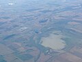 Lake Cowal 2015.JPG 2,592 × 1,936; 956 KB
-

-
 Telephone Pole - NSW Australia.jpg 2,448 × 3,264; 2.38 MB
-
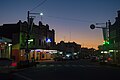 West wyalong at night.jpg 5,819 × 3,869; 12.57 MB
-
 West Wyalong Banner.jpg 3,720 × 532; 987 KB
-
 West Wyalong Commercial Banking Company of Sydney.JPG 3,540 × 2,492; 3.21 MB
-
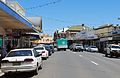 West Wyalong Main Street 001.JPG 3,768 × 2,452; 3.41 MB
-
 West Wyalong Main Street 002.JPG 3,628 × 2,512; 3.38 MB
-
 West Wyalong Main Street 003.JPG 3,720 × 2,540; 3.16 MB

_-_West_Wyalong,_NSW,_C._1900_(5861839155).jpg)


