Category:Westhavenkade 58, Vlaardingen
| Object location | | View all coordinates using: OpenStreetMap |
|---|
.jpg) | |||||
| Upload media | |||||
| Instance of |
| ||||
|---|---|---|---|---|---|
| Location | Vlaardingen, South Holland, Netherlands | ||||
| Street address |
| ||||
| Located on street | |||||
| Heritage designation |
| ||||
 | |||||
|
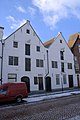
This is a category about rijksmonument number 37432
|
| Address |
|
Media in category "Westhavenkade 58, Vlaardingen"
The following 8 files are in this category, out of 8 total.
-
 Overzicht - Vlaardingen - 20242799 - RCE.jpg 1,200 × 802; 120 KB
-
 Overzicht - Vlaardingen - 20242860 - RCE.jpg 1,200 × 949; 214 KB
-
 Overzicht - Vlaardingen - 20242861 - RCE.jpg 1,200 × 950; 206 KB
-
 Rijksmonument 37431 (Vlaardingen).jpg 1,200 × 1,802; 1.34 MB
-
 RM37432 Vlaardingen - Westhavenkade 58.jpg 2,592 × 1,944; 1.06 MB
-
 Voorgevels - Vlaardingen - 20242859 - RCE.jpg 803 × 1,200; 184 KB
-
 Voorgevels - Vlaardingen - 20242862 - RCE.jpg 1,200 × 948; 222 KB
-
 Voorgevels - Vlaardingen - 20242863 - RCE.jpg 1,200 × 951; 232 KB


