Category:Westminster Road Fire & Police Station
| Object location | | View all coordinates using: OpenStreetMap |
|---|
This is a category about listed building number 1392283. |
police station in Liverpool, Merseyside, England, UK  | |||||
| Upload media | |||||
| Instance of | |||||
|---|---|---|---|---|---|
| Location | Liverpool, Merseyside, North West England, England | ||||
| Heritage designation |
| ||||
 | |||||
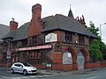
A complex of buildings, 1885, by City Architect Thomas Shelmerdine, shared by the police and fire services. Comprising an engine shed, parade ground, bridewell and police offices, it was vacated in 1985 and converted into a pub, "The Old Bill". That closed in 2000, the building becamse derelict and was Grade II listed in 2007 to preserve it. It is now used partly as an industrial unit, and partly as apartments.
Media in category "Westminster Road Fire & Police Station"
The following 8 files are in this category, out of 8 total.
-
 Benchmark at Westminster Road Police Station, Kirkdale.jpg 2,934 × 4,217; 7.01 MB
-
 Former Fire and Police Station Westminster Road Liverpool Merseyside England UK.jpg 3,466 × 2,600; 1.37 MB
-
 Liver bird, Westminster Road police station.jpg 4,466 × 3,349; 11.92 MB
-
 The Old Bill, Kirkdale.jpg 1,280 × 960; 589 KB
-
 Westminster Road fire station.jpg 9,393 × 3,242; 14.42 MB
-
 Westminster Road police station 1.jpg 4,124 × 2,954; 7.83 MB
-
 Westminster Road police station 2.jpg 4,818 × 3,222; 14.99 MB
-
 Westminster Road police station 3.jpg 4,821 × 2,943; 10.47 MB


