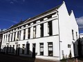
Category:Wijde Begijnestraat 15, Utrecht
| Object location | | View all coordinates using: OpenStreetMap |
|---|
 | |||||
| Upload media | |||||
| Instance of | |||||
|---|---|---|---|---|---|
| Location | Utrecht, Netherlands | ||||
| Located on street | |||||
| Heritage designation |
| ||||
 | |||||
|
This is a category about rijksmonument number 450393
|
| Address |
|
Media in category "Wijde Begijnestraat 15, Utrecht"
The following 6 files are in this category, out of 6 total.
-
 Exterieur VOORGEVEL - Utrecht - 20303532 - RCE.jpg 788 × 1,200; 145 KB
-
 Exterieur VOORGEVEL - Utrecht - 20303533 - RCE.jpg 788 × 1,200; 181 KB
-
 Voor- en zijgevel - Utrecht - 20237210 - RCE.jpg 1,200 × 960; 156 KB
-
 Voorgevel - Utrecht - 20235476 - RCE.jpg 802 × 1,200; 148 KB
-
 Voorgevel - Utrecht - 20237211 - RCE.jpg 1,200 × 953; 202 KB
-
 WijdeBegijnestraat.15-17-19-21.Utrecht.jpg 3,785 × 2,838; 3.9 MB


