Category:Wijdstraat 17, Oudewater
| Object location | | View all coordinates using: OpenStreetMap |
|---|
 | |||||
| Upload media | |||||
| Instance of |
| ||||
|---|---|---|---|---|---|
| Location | Oudewater, South Holland, Netherlands | ||||
| Street address |
| ||||
| Located on street |
| ||||
| Heritage designation |
| ||||
 | |||||
|
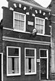
This is a category about rijksmonument number 32088
|
| Address |
|
Media in category "Wijdstraat 17, Oudewater"
The following 4 files are in this category, out of 4 total.
-
 3421 Oudewater, Netherlands - panoramio (26).jpg 2,048 × 1,148; 417 KB
-
 Aanzicht - Oudewater - 20180093 - RCE.jpg 1,193 × 1,200; 275 KB
-
 RM32088 Oudewater - Wijdstraat 17.jpg 1,944 × 2,592; 1.32 MB
-
 Voorgevel - Oudewater - 20180084 - RCE.jpg 805 × 1,200; 231 KB
.jpg)

