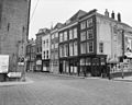
Category:Wijnstraat 182, Dordrecht
| Object location | | View all coordinates using: OpenStreetMap |
|---|
building in Dordrecht, Netherlands  | |||||
| Upload media | |||||
| Instance of | |||||
|---|---|---|---|---|---|
| Location | Dordrecht, South Holland, Netherlands | ||||
| Street address |
| ||||
| Heritage designation |
| ||||
 | |||||
|
This is a category about rijksmonument number 14036
|
| Address |
|
Media in category "Wijnstraat 182, Dordrecht"
The following 7 files are in this category, out of 7 total.
-
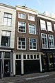 Dordrecht - Wijnstraat 182.JPG 3,056 × 4,592; 4.38 MB
-
 Overzicht - Dordrecht - 20063213 - RCE.jpg 1,200 × 960; 275 KB
-
 Overzicht van de voorgevels en een rechter zijgevel - Dordrecht - 20379366 - RCE.jpg 1,200 × 1,175; 256 KB
-
 Overzicht voorgevels - Dordrecht - 20063229 - RCE.jpg 1,200 × 958; 271 KB
-
 Overzicht voorgevels - Dordrecht - 20063230 - RCE.jpg 966 × 1,200; 256 KB
-
 Overzicht voorgevels - Dordrecht - 20063231 - RCE.jpg 1,200 × 959; 267 KB
-
 Uitmonding op Scheffersplein ( oost wand) - Dordrecht - 20063074 - RCE.jpg 951 × 1,200; 263 KB


_-_Dordrecht_-_20063074_-_RCE.jpg)