Category:Wilhelm-Erbstollen
English: Slate mine Wilhelm-Erbstollen, Kaub, Rhineland-Palatinate, Germany
| Object location | | View all coordinates using: OpenStreetMap |
|---|
Merger of slate mines in Kaub, Germany  | |||||
| Upload media | |||||
| Instance of |
| ||||
|---|---|---|---|---|---|
| Location | Kaub, Verbandsgemeinde Loreley, Rhein-Lahn-Kreis, Rhineland-Palatinate, Germany | ||||
| Heritage designation | |||||
 | |||||
Subcategories
This category has the following 2 subcategories, out of 2 total.
D
- Dicker Turm (Kaub) (8 F)
R
Media in category "Wilhelm-Erbstollen"
The following 15 files are in this category, out of 15 total.
-
 20111210 KaubSpalthausGrubeWilhelmErbstollen.JPG 3,648 × 2,564; 5.42 MB
-
 20111210 KaubStollenhausZechenhausWilhelmErbstollen.JPG 3,648 × 2,736; 3.13 MB
-
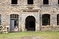
 20120108 KaubPortalWilhelmErbstollen.JPG 2,781 × 1,800; 1.37 MB
-
 Kaub Grube Ernestine Schacht-01.JPG 4,145 × 2,901; 4.48 MB
-
 Kaub Grube Ernestine Schacht-02.JPG 5,184 × 3,456; 5.74 MB
-
 Kaub Grube Ernestine Schacht.jpg 1,333 × 2,000; 2.68 MB
-
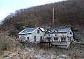
 Kaub Wilhelm Erbstollen Gesamtanlage (01).jpg 4,947 × 3,298; 2.78 MB
-
 Kaub Wilhelm Erbstollen Spalthaus (01).jpg 5,184 × 3,456; 6.63 MB
-
 Kaub Wilhelm Erbstollen Zechenhaus (01).jpg 5,184 × 3,456; 7.91 MB
-
 Kaub Wilhelm Erbstollen Zechenhaus Portal 2014.JPG 5,058 × 3,355; 3.09 MB
-
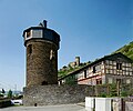 Kaub, Dicker Turm.jpg 3,982 × 3,331; 5.39 MB
-
 Kaub-Erbstollen-01.jpg 2,559 × 2,058; 1,009 KB
-
 Kaub-Erbstollen-02e.jpg 1,924 × 2,592; 861 KB
-
 KaubWilhelmErbstollenDiemaDGL20.JPG 2,816 × 1,880; 967 KB
-
 KaubWilhelmErbstollenGesamtanlage.JPG 3,888 × 2,592; 10.21 MB


.jpg)
.jpg)
.jpg)


