Category:Windmühle Osterbruch
| Object location | | View all coordinates using: OpenStreetMap |
|---|
 | |||||
| Upload media | |||||
| Instance of | |||||
|---|---|---|---|---|---|
| Location | Osterbruch, Land Hadeln, Cuxhaven, Lower Saxony, Germany | ||||
| Heritage designation | |||||
 | |||||
Media in category "Windmühle Osterbruch"
The following 24 files are in this category, out of 24 total.
-
 Osterbruch -Windmühle Osterbruch Mühlstein- 2005 by-RaBoe 001.JPG 1,200 × 1,600; 428 KB
-
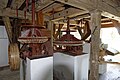
 Osterbruch 2003 -Galerie Holländermühle Schweinskopf- by-RaBoe 01.jpg 1,584 × 866; 786 KB
-
 Osterbruch 2005 -Galerie Holländermühle Schweinskopf- by-RaBoe 01.jpg 1,600 × 1,200; 400 KB
-
 Osterbruch 2005 -Galerie Holländermühle Schweinskopf- by-RaBoe 04.jpg 1,156 × 1,567; 1.36 MB
-
 Osterbruch 2005 -Galerie Holländermühle Schweinskopf- by-RaBoe 05.jpg 1,200 × 1,600; 445 KB
-
 Osterbruch 2005 -Galerie Holländermühle Schweinskopf- by-RaBoe 06.jpg 1,200 × 1,600; 435 KB
-
 Osterbruch 2011-by-RaBoe-01.jpg 797 × 1,200; 1.14 MB
-
 Osterbruch 2011-by-RaBoe-02.jpg 797 × 1,200; 1.03 MB
-
 Osterbruch 2018 - Offene Tür im Mühlenmuseum - by-RaBoe 03.jpg 2,216 × 3,666; 847 KB
-
 Osterbruch 2018 - Offene Tür im Mühlenmuseum - by-RaBoe 05.jpg 3,666 × 2,435; 963 KB
-
 Osterbruch 2018 - Offene Tür im Mühlenmuseum - by-RaBoe 06.jpg 3,666 × 2,435; 939 KB
-
 Osterbruch 2018 - Offene Tür im Mühlenmuseum - by-RaBoe 07.jpg 2,435 × 3,666; 976 KB
-
 Osterbruch 2018 - Offene Tür im Mühlenmuseum - by-RaBoe 08.jpg 2,435 × 3,666; 999 KB
-
 Osterbruch 2018 - Offene Tür im Mühlenmuseum - by-RaBoe 09.jpg 2,435 × 3,666; 855 KB
-
 Osterbruch 2018 - Offene Tür im Mühlenmuseum - by-RaBoe 10.jpg 2,435 × 3,666; 1.01 MB
-
 Osterbruch 2018 - Offene Tür im Mühlenmuseum - by-RaBoe 12.jpg 3,666 × 2,435; 963 KB
-
 Osterbruch 2018 - Offene Tür im Mühlenmuseum - by-RaBoe 13.jpg 3,666 × 2,435; 1,006 KB
-
 Osterbruch 2018 - Offene Tür im Mühlenmuseum - by-RaBoe 14.jpg 3,666 × 2,435; 996 KB
-
 Osterbruch 2018 - Offene Tür im Mühlenmuseum - by-RaBoe 15.jpg 3,666 × 2,435; 1.08 MB
-
 Osterbruch 2018 - Offene Tür im Mühlenmuseum - by-RaBoe 16.jpg 3,666 × 2,435; 1.07 MB
-
 Osterbruch 2018 - Offene Tür im Mühlenmuseum - by-RaBoe 17.jpg 3,666 × 2,435; 962 KB
-
 Osterbruch 2018 - Offene Tür im Mühlenmuseum - by-RaBoe 18.jpg 2,435 × 3,666; 1,015 KB
-
 Osterbruch 2018 - Offene Tür im Mühlenmuseum - by-RaBoe 19.jpg 2,435 × 3,666; 715 KB
-
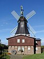
 Osterbrucher Muehle.jpg 2,736 × 3,648; 3.13 MB


