Category:Wingrave with Rowsham
English: Wingrave with Rowsham is a civil parish in the Aylesbury Vale district, in the county of Buckinghamshire, England.
civil parish in Buckinghamshire, England | |||||
| Upload media | |||||
| Instance of | |||||
|---|---|---|---|---|---|
| Location |
| ||||
 | |||||
Media in category "Wingrave with Rowsham"
The following 92 files are in this category, out of 92 total.
-

-
 Approaching Hale Farm Rowsham - geograph.org.uk - 717439.jpg 640 × 425; 67 KB
-
 Bend in Leighton Road - geograph.org.uk - 2594308.jpg 640 × 480; 109 KB
-
 Bend on the A418, Rowsham - geograph.org.uk - 5677296.jpg 2,304 × 1,728; 1.47 MB
-
 Church of Saint Peter and Saint Paul, Wingrave - geograph.org.uk - 4135694.jpg 4,320 × 3,240; 4.38 MB
-

-
 Field of cows north of Rowsham - geograph.org.uk - 4991877.jpg 800 × 582; 107 KB
-
 Fields and Hay Bales - geograph.org.uk - 197535.jpg 640 × 480; 70 KB
-
 Footpath across the recreation ground - geograph.org.uk - 3501638.jpg 1,600 × 1,067; 546 KB
-
 Footpath to Aston Abbotts - geograph.org.uk - 1734819.jpg 2,592 × 1,944; 2.39 MB
-
 Footpath to Church Street - geograph.org.uk - 3501639.jpg 1,200 × 1,600; 722 KB
-
 Footpath to Lower End - geograph.org.uk - 3501630.jpg 1,600 × 1,067; 718 KB
-
 Former Infant School, Rowsham - geograph.org.uk - 197716.jpg 640 × 619; 89 KB
-
 Garage on Dark Lane, Wingrave - geograph.org.uk - 5677291.jpg 2,238 × 1,636; 1.25 MB
-
 Green on Winslow Road, Wingrave - geograph.org.uk - 5677292.jpg 2,304 × 1,728; 803 KB
-
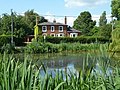
 House along the A418 in Rowsham - geograph.org.uk - 4991836.jpg 800 × 577; 183 KB
-
 Houses and ducks on Dark Lane - geograph.org.uk - 3501726.jpg 1,600 × 1,068; 420 KB
-
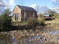 Independent Chapel - geograph.org.uk - 1734805.jpg 2,592 × 1,944; 2.57 MB
-
 Leafy lane to the recreation ground - geograph.org.uk - 3501731.jpg 1,600 × 1,067; 562 KB
-
 Leighton Road, Wingrave - geograph.org.uk - 4013911.jpg 640 × 480; 167 KB
-

-

-
 Manor Road - geograph.org.uk - 1734815.jpg 2,592 × 1,944; 2.63 MB
-
 New homes in Leighton Road - geograph.org.uk - 2594298.jpg 640 × 480; 66 KB
-
 Old Hale Farmhouse - geograph.org.uk - 197342.jpg 640 × 480; 97 KB
-
 Ornate gates to East Lodge - geograph.org.uk - 3501748.jpg 1,600 × 1,067; 522 KB
-
 Outhouse on Leighton Road - geograph.org.uk - 3501743.jpg 1,600 × 1,072; 502 KB
-

-
 Pavilion on the recreation ground - geograph.org.uk - 3501627.jpg 1,600 × 1,067; 420 KB
-
 Former Independent Chapel, Rowsham - geograph.org.uk - 197530.jpg 480 × 640; 136 KB
-
 Slow approach to Wingrave - geograph.org.uk - 3501736.jpg 1,200 × 1,600; 507 KB
-
-

-

-

-
 SS Peter ^ Paul, Wingrave, lectern - geograph.org.uk - 2605424.jpg 480 × 640; 78 KB
-
 SS Peter ^ Paul, Wingrave, lych gate - geograph.org.uk - 2604178.jpg 480 × 640; 92 KB
-

-

-

-

-

-

-

-

-
 SS Peter ^ Paul, Wingrave, pulpit - geograph.org.uk - 2605419.jpg 480 × 640; 71 KB
-

-

-

-

-

-
 SS Peter ^ Paul, Wingrave, tomb - geograph.org.uk - 2604217.jpg 640 × 480; 87 KB
-
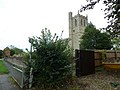
 SS Peter ^ Paul, Wingrave, tower - geograph.org.uk - 2604192.jpg 480 × 640; 70 KB
-
 St Peter and Paul Wingrave - geograph.org.uk - 3501648.jpg 1,600 × 1,068; 357 KB
-
 St Peter ^ St Paul, Wingrave - Chancel - geograph.org.uk - 2610845.jpg 1,000 × 676; 144 KB
-
 St Peter ^ St Paul, Wingrave - Chancel - geograph.org.uk - 2610848.jpg 1,000 × 703; 151 KB
-
 St Peter ^ St Paul, Wingrave - Churchyard - geograph.org.uk - 2610842.jpg 1,000 × 650; 179 KB
-
 St Peter ^ St Paul, Wingrave - Churchyard cross - geograph.org.uk - 2610876.jpg 653 × 1,000; 252 KB
-
 St Peter ^ St Paul, Wingrave - East end - geograph.org.uk - 2610877.jpg 1,000 × 681; 156 KB
-
 St Peter ^ St Paul, Wingrave - Font - geograph.org.uk - 2610861.jpg 580 × 1,000; 126 KB
-
 St Peter ^ St Paul, Wingrave - geograph.org.uk - 2610835.jpg 1,000 × 603; 140 KB
-
 St Peter ^ St Paul, Wingrave - geograph.org.uk - 2610869.jpg 1,000 × 661; 169 KB
-
 St Peter ^ St Paul, Wingrave - geograph.org.uk - 2610872.jpg 649 × 1,000; 192 KB
-
 St Peter ^ St Paul, Wingrave - Piscina ^ sedilia - geograph.org.uk - 2610850.jpg 1,000 × 737; 153 KB
-

-

-
 St Peter ^ St Paul, Wingrave - Wall monument - geograph.org.uk - 2610863.jpg 863 × 1,000; 151 KB
-
 St Peter ^ St Paul, Wingrave - Windows - geograph.org.uk - 2610866.jpg 1,000 × 678; 223 KB
-
 The A418 towards Leighton Buzzard - geograph.org.uk - 4991895.jpg 800 × 647; 191 KB
-
 The A418, Wingrave - geograph.org.uk - 5677263.jpg 2,304 × 1,728; 819 KB
-
 The entrance to Hollie Farm, Wingrave - geograph.org.uk - 5680270.jpg 2,304 × 1,728; 810 KB
-
 The Rose and Crown pub, Wingrave - geograph.org.uk - 4135520.jpg 4,320 × 3,240; 3.31 MB
-
 The Tower of St Peter and St Paul - geograph.org.uk - 3501650.jpg 1,200 × 1,600; 589 KB
-
 The track to Seabrook Farm - geograph.org.uk - 197710.jpg 640 × 480; 113 KB
-
 Track off the A418, Rowsham - geograph.org.uk - 5677295.jpg 2,200 × 1,582; 1.12 MB
-
 Tring Grove, Wingrave - geograph.org.uk - 5677290.jpg 2,200 × 1,580; 1.08 MB
-
 Tring Road enters Wingrave - geograph.org.uk - 3501738.jpg 1,600 × 1,070; 546 KB
-
 Tring Road, Wingrave - geograph.org.uk - 5680269.jpg 2,304 × 1,728; 854 KB
-
 Village pond, Wingrave - geograph.org.uk - 4013899.jpg 640 × 480; 145 KB
-
 War memorial, Wingrave - geograph.org.uk - 4135525.jpg 4,320 × 3,240; 4.94 MB
-
 Wingrave - SS Peter ^ Paul - Carved stone corbel - geograph.org.uk - 4311264.jpg 1,111 × 1,000; 772 KB
-
 Wingrave - SS Peter ^ Paul - Chancel - geograph.org.uk - 4310735.jpg 1,000 × 1,395; 1,016 KB
-
 Wingrave - SS Peter ^ Paul - Nave - geograph.org.uk - 4310731.jpg 1,000 × 1,333; 970 KB
-
 Wingrave - SS Peter ^ Paul - Norman font - geograph.org.uk - 4311272.jpg 1,000 × 1,170; 903 KB
-
 Wingrave - SS Peter ^ Paul - St George and St Alban - geograph.org.uk - 4311261.jpg 1,000 × 1,423; 1.12 MB
-
 Wingrave - SS Peter ^ Paul from churchyard - geograph.org.uk - 4310715.jpg 1,333 × 1,000; 1.09 MB
-
 Wingrave Methodist Church, Bucks - geograph.org.uk - 4512682.jpg 3,072 × 2,304; 1.78 MB
-
 Wingrave pond - geograph.org.uk - 4135538.jpg 4,320 × 3,240; 4.77 MB
-
 Wingrave village pond - geograph.org.uk - 3501653.jpg 1,600 × 1,067; 614 KB
-
 Winslow Road, Nup End - geograph.org.uk - 5677293.jpg 2,304 × 1,728; 815 KB
-
 Winslow Road, Nup End - geograph.org.uk - 5677294.jpg 2,304 × 1,728; 849 KB
-


_-_geograph.org.uk_-_2605416.jpg)
_-_geograph.org.uk_-_2605431.jpg)
_-_geograph.org.uk_-_2605433.jpg)
_-_geograph.org.uk_-_2605449.jpg)
_-_geograph.org.uk_-_2605456.jpg)
_-_geograph.org.uk_-_2605461.jpg)


_-_geograph.org.uk_-_2605414.jpg)
_-_geograph.org.uk_-_2605427.jpg)
_-_geograph.org.uk_-_2605440.jpg)
_-_geograph.org.uk_-_2605458.jpg)


