Category:Winter in Lancashire
Ceremonial counties of England: Bedfordshire · Berkshire · Buckinghamshire · Cambridgeshire · Cheshire · Cornwall · Cumbria · Derbyshire · Devon · Dorset · Durham · East Riding of Yorkshire · East Sussex · Essex · Gloucestershire · Greater London · Greater Manchester · Hampshire · Herefordshire · Hertfordshire · Isle of Wight · Kent · Lancashire · Leicestershire · Lincolnshire · Merseyside · Norfolk · North Yorkshire · Northamptonshire · Northumberland · Nottinghamshire · Oxfordshire · Rutland · Shropshire · Somerset · South Yorkshire · Staffordshire · Suffolk · Surrey · Tyne and Wear · Warwickshire · West Sussex · West Yorkshire · Wiltshire · Worcestershire
City-counties: Bristol ·
Former historic counties:
Other former counties:
City-counties: Bristol ·
Former historic counties:
Other former counties:
Media in category "Winter in Lancashire"
The following 37 files are in this category, out of 37 total.
-
 Band Stand, Victoria Park, Nelson.jpg 3,000 × 2,000; 5.88 MB
-
 Haslingden in Snow - 8392479651.jpg 1,024 × 768; 183 KB
-
 Haslingden in Snow - 8393565174.jpg 1,024 × 450; 98 KB
-
 Haslingden in Snow - 8393565334.jpg 1,024 × 437; 127 KB
-
 Musbury Tor in the snow.jpg 1,263 × 943; 225 KB
-
 Ogden Reservoirs 030.jpg 2,640 × 1,980; 651 KB
-
 Ogden Reservoirs 031.jpg 2,640 × 1,980; 821 KB
-
 Ogden Reservoirs 037.jpg 2,640 × 1,980; 1.29 MB
-
 Ogden Reservoirs 044.jpg 2,640 × 1,980; 930 KB
-
 Ogden Reservoirs 045.jpg 2,640 × 1,980; 994 KB
-
 Ogden Reservoirs 046.jpg 2,640 × 1,980; 1.07 MB
-
 Ogden Reservoirs 047.jpg 2,640 × 1,980; 1.11 MB
-
 Ogden Reservoirs 048.jpg 2,640 × 1,980; 923 KB
-
 Ogden Reservoirs 050.jpg 2,640 × 1,980; 823 KB
-
 Ogden Reservoirs 055.jpg 2,640 × 1,980; 941 KB
-
 Ogden Reservoirs 056.jpg 1,980 × 2,640; 1.02 MB
-
 Ogden Reservoirs 057.jpg 2,640 × 1,980; 929 KB
-
 Ogden Reservoirs 058.jpg 1,980 × 2,640; 904 KB
-
 Ogden Reservoirs 059.jpg 2,640 × 1,980; 973 KB
-
 Parish Church of St Leonard, Downham - geograph.org.uk - 1580572.jpg 640 × 453; 109 KB
-
 Pendle Hill - geograph.org.uk - 1171904.jpg 640 × 479; 42 KB
-
 Pendle Hill from Burnley - geograph.org.uk - 1092515.jpg 640 × 480; 84 KB
-
 Pendle House - geograph.org.uk - 1141676.jpg 640 × 480; 125 KB
-
 Ramsbottom in Snow - 8392479779.jpg 1,024 × 659; 261 KB
-
 Reservoir Outflow - geograph.org.uk - 1127432.jpg 640 × 480; 116 KB
-
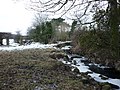
 River Wenning from Hornby Bridge - geograph.org.uk - 640191.jpg 640 × 480; 88 KB
-

-
 River Wenning, Hornby - geograph.org.uk - 640208.jpg 480 × 640; 126 KB
-

-

-
 Swinden Reservoirs - geograph.org.uk - 675004.jpg 640 × 427; 78 KB
-
 The bridges of Burrow Beck - geograph.org.uk - 1657406.jpg 640 × 480; 135 KB
-

-
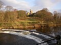 The weir on the River Wenning, Hornby - geograph.org.uk - 643196.jpg 640 × 469; 85 KB
-
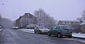 Todmorden Road, Bacup - geograph.org.uk - 1692173.jpg 1,600 × 830; 222 KB
-
 Fallen rime - geograph.org.uk - 652883.jpg 640 × 426; 233 KB
-
 Folly Lane - geograph.org.uk - 154533.jpg 640 × 418; 61 KB


,_Tarleton_-_geograph.org.uk_-_1102761.jpg)


