Category:Wisconsin Highway 22
 | number: | (twenty-two) |
|---|---|---|
| State highways in Wisconsin: | 11 · 12 · 13 · 14 · 15 · 16 · 17 · 19 · 20 · 21 · 22 · 23 · 24 · 25 · 26 · 27 · 28 · 29 · 30 · 31 · 32 · 33 · 34 · 35 · 36 · 37 · 38 · 39 · 40 · 42 |
state highway in Wisconsin, United States  | |||||
| Upload media | |||||
| Instance of | |||||
|---|---|---|---|---|---|
| Location | |||||
| Transport network | |||||
| Owned by | |||||
| Maintained by | |||||
| Length |
| ||||
| |||||
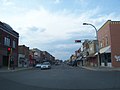
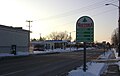
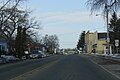
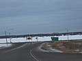
English: Media related to Wisconsin Highway 22, a 171.60-mile (276.16 km) state highway in eastern Wisconsin, United States.
Subcategories
This category has only the following subcategory.
Media in category "Wisconsin Highway 22"
The following 37 files are in this category, out of 37 total.
-
 CecilWisconsin.jpg 2,304 × 1,728; 734 KB
-
 ClintonvilleWisconsinPostOffice.jpg 1,673 × 771; 968 KB
-
 ClintonvilleWisconsinSign.jpg 2,304 × 1,728; 646 KB
-
 ClintonvilleWisconsinUS45WIS22.jpg 2,304 × 1,728; 722 KB
-
 FoxRiverWisconsinMontelloWestWIS22.jpg 2,304 × 1,728; 864 KB
-
 GillettAreaHistoricalMuseumWIS22.jpg 1,936 × 1,288; 1.17 MB
-
 GillettWisconsinSchoolWIS22.jpg 2,976 × 1,984; 2.47 MB
-
 ManawaWisconsinDowntown1.jpg 2,304 × 1,433; 1.83 MB
-
 ManawaWisconsinSign.jpg 2,000 × 1,460; 1.37 MB
-
 MontelloWisconsinDowntownWIS23WIS22.jpg 2,267 × 925; 390 KB
-
 North Leeds Wisconsin Looking north WIS22.jpg 2,592 × 1,728; 1.79 MB
-
 Oconto Falls WI 1.jpg 4,085 × 2,607; 1.67 MB
-
 Oconto Falls WI 2.jpg 4,378 × 3,102; 2.69 MB
-
 Oconto Falls WI 3.jpg 4,490 × 3,196; 2.74 MB
-
 OcontoFallsWisconsinDowntownWIS22.jpg 1,936 × 1,288; 905 KB
-
 OcontoFallsWisconsinSignWIS22.jpg 1,936 × 1,288; 1,005 KB
-
 OcontoRiverWIS22OcontoFalls.jpg 1,936 × 1,288; 1.08 MB
-
 OcontoWisconsinUS41WIS22EastTerminus.jpg 2,304 × 1,728; 779 KB
-
 Shawano WI 1.jpg 4,752 × 3,289; 2.17 MB
-
 Shawano WI 2.jpg 4,739 × 3,229; 1.98 MB
-
 ShawanoCountyFairgroundsSignWIS47WIS55WIS22.jpg 1,728 × 2,304; 810 KB
-
 ShawanoWisconsinMainStreetHistoricDistrict1WIS22.jpg 2,304 × 1,728; 782 KB
-
 ShawanoWisconsinMainStreetHistoricDistrict2WIS22.jpg 2,304 × 1,728; 820 KB
-
 Wautoma sign.jpg 3,072 × 1,945; 1.09 MB
-
 Wild Rose sign.jpg 3,072 × 1,697; 1 MB
-
 WildRoseMercantile.jpg 3,701 × 2,001; 1.46 MB
-
 WildRoseWisconsinDowntownWIS22.jpg 1,936 × 1,288; 1.11 MB
-
 WildRoseWisconsinVillageHallWIS22.jpg 1,812 × 1,140; 727 KB
-
 WIS 22.svg 384 × 384; 3 KB
-
 Wis-22-map.png 960 × 569; 278 KB
-
 WIS117NorthTerminusWIS22.jpg 2,304 × 1,728; 751 KB
-
 WIS22WIS117.jpg 2,268 × 1,493; 612 KB
-
 Wis32Wis22.jpg 2,304 × 1,728; 815 KB
-
 Wisconsin Highway 22 in Columbia County at County EE.jpg 1,920 × 1,280; 800 KB
-
 WisconsinHighway161EastTerminusWIS110.jpg 1,871 × 1,366; 1.2 MB
-
 WisconsinHighway76NorthwestTerminus.jpg 2,304 × 1,728; 758 KB
-
 Wyocena WI Sign WIS22.jpg 1,920 × 1,280; 1.1 MB


