Category:Wohn- und Geschäftshaus (Aareweg 6, Aarberg)
| Object location | | View all coordinates using: OpenStreetMap |
|---|
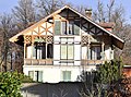
residential and commercial building in Aarberg in the canton of Bern, Switzerland  | |||||
| Upload media | |||||
| Instance of | |||||
|---|---|---|---|---|---|
| Part of | |||||
| Location | Aarberg, Seeland administrative district, Seeland administrative region, Bern, Switzerland | ||||
| Street address |
| ||||
| Heritage designation |
| ||||
| Inception |
| ||||
| Elevation above sea level |
| ||||
 | |||||
Media in category "Wohn- und Geschäftshaus (Aareweg 6, Aarberg)"
This category contains only the following file.
-
 Aarberg-Aareweg-6-1910.jpg 1,316 × 976; 406 KB