Category:Wooddale Bridge
| Object location | | View all coordinates using: OpenStreetMap |
|---|
|
This is a category about a place or building that is listed on the National Register of Historic Places in the United States of America. Its reference number is 73000552. |
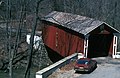
covered bridge over Red Clay Creek at Wooddale in New Castle County, Delaware, United States  | |||||
| Upload media | |||||
| Instance of | |||||
|---|---|---|---|---|---|
| Location | Delaware | ||||
| Crosses |
| ||||
| Heritage designation |
| ||||
| Inception |
| ||||
| Significant event |
| ||||
 | |||||
Media in category "Wooddale Bridge"
The following 3 files are in this category, out of 3 total.
-
 Wooddale Bridge Delaware 2015.JPG 4,608 × 3,072; 5.65 MB
-
 WOODDALE BRIDGE.jpg 5,253 × 3,435; 1.38 MB
-
 Wooddale Covered Bridge Plaque.jpg 1,080 × 810; 185 KB

