Category:Wootton, East Staffordshire
English: Wootton is a settlement and civil parish in the East Staffordshire district, in the county of Staffordshire, England.
village and civil parish in Staffordshire, UK  | |||||
| Upload media | |||||
| Instance of | |||||
|---|---|---|---|---|---|
| Location | East Staffordshire, Staffordshire, West Midlands, England | ||||
 | |||||
Media in category "Wootton, East Staffordshire"
The following 38 files are in this category, out of 38 total.
-
 Bench mark, Tollgate Cottage, Wootton - geograph.org.uk - 5307380.jpg 1,280 × 960; 552 KB
-
 Cattle grid next to a plantation - geograph.org.uk - 2315622.jpg 640 × 480; 87 KB
-
 Common Lane - geograph.org.uk - 5008065.jpg 5,184 × 3,456; 1.7 MB
-
 Crossroads at Dale Cottage - geograph.org.uk - 5849021.jpg 1,436 × 1,076; 584 KB
-
 Dale Cottage - geograph.org.uk - 5008064.jpg 4,659 × 2,547; 1.42 MB
-
 Dale Lane by Stanton Dale Farm - geograph.org.uk - 5849025.jpg 1,306 × 979; 594 KB
-
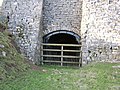
 Disused limekilns at the Weaver Hills - geograph.org.uk - 315266.jpg 640 × 480; 108 KB
-
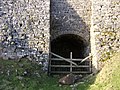
 Disused limekilns at the Weaver Hills - geograph.org.uk - 315267.jpg 640 × 480; 115 KB
-
 Disused limekilns at the Weaver Hills - geograph.org.uk - 315268.jpg 640 × 480; 126 KB
-
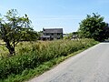
 Fields near New House Farm, Wootton - geograph.org.uk - 5307382.jpg 1,280 × 960; 402 KB
-
 Footpath to Waterhouses - geograph.org.uk - 2315628.jpg 640 × 480; 104 KB
-
 Gateway, Gidacre Lane - geograph.org.uk - 1071787.jpg 640 × 480; 139 KB
-
 Grazing calves - geograph.org.uk - 4458757.jpg 4,320 × 3,240; 3.98 MB
-
 Greens Hill, Delbert - geograph.org.uk - 2481099.jpg 1,496 × 1,122; 1.02 MB
-
 Hall Lane, Wootton - geograph.org.uk - 5307385.jpg 1,280 × 958; 652 KB
-
 Landscape near Dale Abbey Farm - geograph.org.uk - 5307390.jpg 1,280 × 863; 251 KB
-
 Lane on Weaver Hill - geograph.org.uk - 2315617.jpg 640 × 480; 78 KB
-
 Milepost at SK1010947618.jpg 492 × 701; 71 KB
-

-
 Parting of the ways, Weaver Farm - geograph.org.uk - 5307387.jpg 1,280 × 960; 487 KB
-
 Sandy Lane - geograph.org.uk - 5098831.jpg 1,280 × 960; 740 KB
-
 Stanton Dale Farm - geograph.org.uk - 5008068.jpg 5,076 × 2,788; 1.78 MB
-
 Stile without a purpose - geograph.org.uk - 2315595.jpg 640 × 480; 97 KB
-
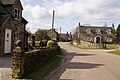 Stone houses in Wootton village - geograph.org.uk - 366158.jpg 640 × 428; 111 KB
-
 Sunday strollers - geograph.org.uk - 2315580.jpg 640 × 480; 80 KB
-
 The A52 - quiet for a change - geograph.org.uk - 2315598.jpg 640 × 480; 96 KB
-
 The lane to Walk Farm - geograph.org.uk - 5307386.jpg 1,280 × 960; 446 KB
-
 The road to the Weaver Hills - geograph.org.uk - 366160.jpg 640 × 418; 147 KB
-
 Thorswood Grange - geograph.org.uk - 5008062.jpg 4,406 × 3,224; 1.77 MB
-
 Thorswood Grange - geograph.org.uk - 5848616.jpg 1,373 × 1,030; 581 KB
-
 Thorswood House - geograph.org.uk - 5008060.jpg 4,583 × 2,628; 1.62 MB
-
 Tollgate Cottage - geograph.org.uk - 438731.jpg 640 × 480; 73 KB
-
 Tollgate Cottage, Wootton - geograph.org.uk - 5307377.jpg 1,280 × 1,026; 282 KB
-
 View along Dale Lane - geograph.org.uk - 5848611.jpg 1,469 × 1,102; 421 KB
-
 View towards Caldon Low - geograph.org.uk - 5307391.jpg 1,280 × 960; 309 KB
-
 Weaver Hills - geograph.org.uk - 1537228.jpg 640 × 427; 65 KB
-

-
 Wootton Cricket Club - geograph.org.uk - 2484285.jpg 1,496 × 1,122; 506 KB


.jpg)


